The Waipā River is in the Waikato region of the North Island of New Zealand. The headwaters are in the Rangitoto Range east of Te Kūiti. It flows north for 115 kilometres (71 mi), passing through Ōtorohanga and Pirongia, before flowing into the Waikato River at Ngāruawāhia. It is the Waikato's largest tributary. The Waipā's main tributary is the Puniu River.

The Buller River is a river in the South Island of New Zealand. The Buller has the highest flow of any river in the country during floods, though it is only the 13th longest river; it runs for 177 km (110 mi) from Lake Rotoiti through the Buller Gorge and into the Tasman Sea near the town of Westport. A saddle at 710 m (2,330 ft) separates the Buller from the Motupiko River and that is divided from the Wairau River by a 695 m (2,280 ft) saddle, both aligned along the Alpine Fault, as is the top of the Buller valley.

Westport is a town in the West Coast region of the South Island of New Zealand. Established in 1861, it is the oldest European settlement on the West Coast. Originally named Buller, it is on the right bank and at the mouth of the Buller River, close by the prominent headland of Cape Foulwind. It is connected via State Highway 6 with Greymouth, 100 kilometres (62 mi) to the south, and with Nelson 222 kilometres (138 mi) in the northeast, via the Buller Gorge. The population of the Westport urban area was 4,250 as of June 2023. The Buller District had a population of 9,670.

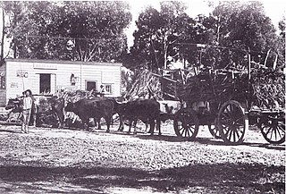
The Stillwater Ngākawau Line (SNL), formerly the Stillwater–Westport Line (SWL) and the Ngakawau Branch, is a secondary main line, part of New Zealand's national rail network. It runs between Stillwater and Ngakawau via Westport on the West Coast of the South Island. It was one of the longest construction projects in New Zealand's history, with its first section, at the south end, opened in 1889, and the beginnings of the Ngākawau Branch, at its Westport end, in 1875. The full line was completed in 1942. The only slower railway projects were Palmerston North to Gisborne, 1872 to 1942, and the Main North Line to Picton, 1872 to 1945.
Tokanui is a community in the eastern portion of Southland District Council, located on the Southern Scenic Route about 56 km (35 mi) east of Invercargill and 107 km (66 mi) southwest of Balclutha, New Zealand. The Tokanui River runs just to the north of the village and occasionally floods the lower parts, as it did when the railway yard flooded in 1935.

The Seddonville Branch, later truncated as the Ngākawau Branch, is a branch line railway in the West Coast region of New Zealand's South Island. Construction began in 1874 and it reached its terminus at the Mokihinui Mine just beyond Seddonville in 1895. In 1981 it was closed past Ngākawau and effectively became an extension of the Stillwater–Westport Line, since formalised as the Stillwater–Ngākawau Line.

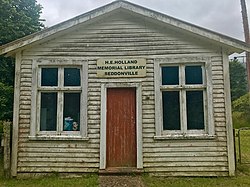
Seddonville is a lightly populated locality on the West Coast of New Zealand's South Island. It is most famous for the historical role it played in New Zealand's coal mining industry.
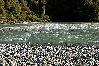
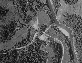
The Mōkihinui River is a river located on the West Coast of New Zealand's South Island, about 40 kilometres north of Westport. Meridian Energy had proposed the Mokihinui Hydro project on the river in 2007 but it was cancelled in May 2012. In 2019, it was announced that 64,400 ha of land in the Mōkihinui River catchment, including 15 km (9.3 mi) of river bed, would be added to Kahurangi National Park.
Hamilton City Libraries are a group of seven libraries in Hamilton, New Zealand, owned by the local city council. They lend fiction and non-fiction, magazines, audiobooks, and DVDs. From November 2016 to 9 July 2018, a substitute library compensated for the temporarily closed Central branch, and the libraries closed for over 2 months for COVID-19 in 2020. Waikato District residents living close to Hamilton City can freely use the Hamilton libraries.

Lyell is the site of a historic gold mining town in the Buller Gorge in the South Island of New Zealand. It lies on State Highway 6, 18 km (11 mi) northeast of Inangahua.

The Hāpuku River begins in the Seaward Kaikōura Range of New Zealand and flows south-east to enter the South Pacific at Hapuka, between Clarence and Kaikōura. The name comes from the Māori word hāpuku or hāpuka, a deep-water marine fish. Its main tributary is the Puhi Puhi River.

Hamilton City Council is the territorial authority for the New Zealand city of Hamilton.

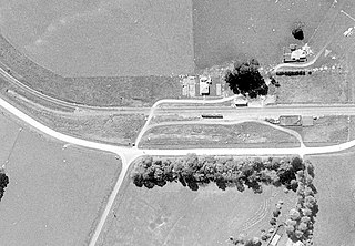
Ngāruawāhia railway station was at the junction of the North Island Main Trunk line and its Glen Massey branch, serving Ngāruawāhia in the Waikato District of New Zealand, 74 mi (119 km) south of Auckland and 10 mi (16 km) north of Hamilton. It was opened with a special train from Auckland on Monday 13 August 1877. The next stations were Taupiri 6.5 km (4.0 mi) to the north and Horotiu 5.5 km (3.4 mi) to the south.
Kimihia Railway Station was on the North Island Main Trunk line, north of Huntly in the Waikato District of New Zealand. The station was in 1886 measured as 19 mi 33 ch (31.2 km) south of Mercer, which is where an unnamed block is shown on the 1929 map, near the junction of Fisher Road with SH1, about 1.4 km (0.87 mi) north of the junction with the Kimihia branch. That junction was 101.06 km (62.80 mi) south of Auckland and 576.54 km (358.25 mi) from Wellington.
Āria is a rural community in the Waitomo District and Waikato region of New Zealand's North Island.
Te Kauwhata was a flag station on the North Island Main Trunk line, in the Waikato District of New Zealand, 54 mi (87 km) south of Auckland. It was 591.52 km (367.55 mi) north of Wellington, 3.32 km (2.06 mi) north of Rangiriri, 6.72 km (4.18 mi) south of Whangamarino and 12 m (39 ft) above sea level.

The Sue Thomson Casey Memorial Library, also known as the Westport Library and the Buller District Library, is a district library located in Westport in the West Coast region of the South Island of New Zealand.
Kopua in New Zealand is now a sparsely populated area, immediately south of the border of the Manawatū-Whanganui and Hawke's Bay regions, with 150 people scattered over a 40 km2 (15 sq mi) meshblock. For two years it briefly flourished as a village, centred on a railway station on the Palmerston North–Gisborne line, opened on 25 January 1878, when it became the southern terminus of the line from Napier and Spit. Building to the south was delayed by the need to erect 3 large viaducts over the Manawatū River and its tributaries, so the extension to Makotuku didn't open until 9 August 1880. Kopua then declined until the station closed on 8 May 1977. Only a single line now passes through the station site and there are remnants of cattle yards.

Rissington is a farming settlement 15 km (9.3 mi) north west of Napier, New Zealand. It lies in Hawke's Bay Region, between Sherenden and Napier, in the Mangaone River valley, on the road to Patoka and Puketitiri. A fire station, cemetery and a war memorial are the only remaining public structures, but it once had several more and was home to the country's first Women's Institute, co-founded by Amy Hutchinson and Bessie Spencer.
Newton River in the Tasman District ), flows west and then south for about 20 km (12 mi) from Mount Newton to the Buller River, 17 km (11 mi) west of Murchison. Near its mouth it is crossed by SH6 on a steel truss bridge with a 120 ft (37 m) main span and two 30 ft (9.1 m) side spans.