New Zealand State Highway 20

Last updated

State Highway 20 NZ.svg

State Highway 20
Southwestern Motorway
Route information
Maintained by NZ Transport Agency
Length25 km (16 mi)
Existed1977–present
Major junctions
South end State Highway 1 NZ.svg SH 1 Southern Motorway at Manukau City Centre
 SH 20B at Puhinui
SH 20A at Mangere
North end State Highway 16 NZ.svg SH 16 Northwestern Motorway at Point Chevalier
Highway system
State Highway 18 NZ.svg SH 18 SH 21 State Highway 21 NZ.svg
Aerial view of the interchange between SH 20 (diagonal from bottom left to upper right) and SH 20A towards the airport (towards bottom right). SH20-SH20A Interchange In Mangere.jpg
Aerial view of the interchange between SH 20 (diagonal from bottom left to upper right) and SH 20A towards the airport (towards bottom right).

State Highway 20, also known as the Southwestern Motorway, is a New Zealand state highway linking State Highway 1 at Manukau City Centre with State Highway 16 in Point Chevalier, via Mangere and Onehunga. Along with its spurs, State Highway 20A and 20B, the state highway serves Auckland Airport, the country's largest, therefore making State Highway 20 a key arterial route connecting the airport to the wider Auckland region and most of the upper North Island. The route also forms the southern part of the Western Ring Route, a 48 kilometres (30 mi) motorway route bypassing central Auckland. It is the only New Zealand State Highway that is entirely motorway.[ citation needed ]

The New Zealand state highway network is the major national highway network in New Zealand. Nearly 100 roads in the North and South Islands are state highways. All state highways are administered by the NZ Transport Agency.

New Zealand State Highway 1 road in New Zealand

State Highway 1 is the longest and most significant road in the New Zealand road network, running the length of both main islands. It appears on road maps as SH 1 and on road signs as a white number 1 on a red shield, but it has the official designations SH 1N in the North Island, SH 1S in the South Island.

Manukau Suburb in Auckland Council, New Zealand

Manukau, or Manukau Central, is a suburb of South Auckland, New Zealand, centred on the Manukau City Centre business district. It is located 23 kilometres south of the Auckland Central Business District, west of the Southern Motorway, south of Papatoetoe, and north of Manurewa. The industrial and commercial suburb of Wiri lies to the east and south.

Contents

Route

SH 20 stretches from the Auckland Southern Motorway (SH 1) at Manukau to SH 16 at Point Chevalier. From south to north the motorway passes through, or adjacent to, the suburbs of Wiri, Mangere, Onehunga, Hillsborough, Mount Roskill, Mount Albert, Waterview and Point Chevalier.

Auckland Southern Motorway road in New Zealand

The Auckland Southern Motorway is the major route south out of the Auckland Region of New Zealand. It is part of State Highway 1.

Point Chevalier Suburb in Auckland Council, New Zealand

Point Chevalier is a suburb and peninsula in the city of Auckland in the north of New Zealand. It is located five kilometres to the west of the city centre on the southern shore of the Waitematā Harbour.

Wiri Suburb in Auckland Council, New Zealand

Wiri is a mostly industrial-commercial focused suburb in Auckland, New Zealand. It was formerly part of Manukau City until the merger of all of Auckland's councils into the 'super city' in 2010.

The final terminus is Northwest Motorway (SH 16) via the Waterview Connection which opened in July 2017. [1]

Waterview Connection road in New Zealand

The Waterview Connection is a motorway section through west/central Auckland, New Zealand. It connects State Highway 20 in the south at Mt Roskill to State Highway 16 in the west at Point Chevalier, and is a part of the Western Ring Route.

Airport connection

SH 20, SH 20A, and SH 20B form an almost triangular shape between the Puhinui Interchange of the Southwestern Motorway, Auckland International Airport, and the SH 20/SH 20A motorway junction. The Southwestern Motorway bypasses Auckland International Airport, with spurs SH 20A from the north and SH 20B from the east both providing airport access.

SH 20A leaves the Southwestern Motorway in Mangere and travels south along an additional stretch of motorway, commonly referred to as the "Airport Motorway". The motorway passes underneath Kirkbride Road at a grade separated intersection which until 2017 was the former terminus for the motorway (and a known black spot). [2] The motorway continues south and terminates at the intersection with Verissimo and Landing Drives [3] where SH 20A also terminates. From there the road continues south, along George Bolt Memorial Drive, to the airport.

SH 20B leaves SH 20 at the Cavendish Dr/Puhinui Rd/Roscommon Rd Interchange of the Southwestern Motorway and travels west along Puhinui Road to the airport, officially terminating at the intersection with Orrs Road.

History

The first section of what would become the Southwestern Motorway was the Onehunga Bypass from Queenstown Road in Hillsborough to Neilson Street in Onehunga, but the start of the motorway proper was not completed until 1983 when the bypass was connected through the new Mangere Bridge to Coronation Road in Mangere.

Mangere Bridge (bridges) bridge in New Zealand

Mangere Bridge, officially also called the Manukau Harbour Crossing, is a dual motorway bridge over the Manukau Harbour in south-western Auckland, New Zealand, crossing between the suburb also known as Mangere Bridge and the suburb of Onehunga.

The northern section was extended first to Hillsborough Road, then to Hayr Road, then to Maioro Street, the last section opening on 15 May 2009. [4]

The southern section was extended to Puhinui Road in 1997, along with the extensions SH 20A and SH 20B connecting to Auckland International Airport. The final southern section connecting Puhinui Road to State Highway 1 at Manukau was completed in 2010. [5] A duplication of Mangere Bridge, with future provision for rail, was also opened in 2010. [6] [7]

The final section of the Southwestern Motorway, the Waterview Connection, connecting Maioro Street with State Highway 16 at the Great North Road Interchange commenced construction in 2012 and opened to traffic in July 2017. [1] [8]

Exit list

Territorial authority Locationkm Exit DestinationsNotes
AucklandOtara-Papatoetoe/Manurewa BoardsManukau CBD0.01State Highway 1 NZ.svg SH 1 south (Southern Motorway) — Hamilton, Tauranga SH 20 and Southwest Motorway begins
State Highway 1 NZ.svg SH 1 north (Southern Motorway) — Auckland
2Lambie Drive — Manukau, Wiri
Puhinui3Route 30 Cavendish Drive/Roscommon Road – Manukau, Wiri No southbound exit (use Puhinui Road)
Northbound entrance and connection to SH 20B and BSicon FLUG.svg
AucklandOtara-Papatoetoe BoardState Highway 20b NZ.svgAirport Sign.svg SH 20B (Puhinui Road) — Airport, Papatoetoe No northbound exit (use Cavendish Drive)
Southbound entrance and connection to SH 20B and BSicon FLUG.svg
AucklandMangere-Otahuhu Board Mangere 7Route 14 Massey Road – Mangere
9State Highway 20a NZ.svgAirport Sign.svg SH 20A — AirportRight-hand southbound exit and northbound entrance.
No southbound entrance (use SH20B or Massey Road)
10Walmsley RoadSouthbound
Coronation RoadNorthbound
Mangere Bridge 12Mahunga Drive — Mangere Bridge Southbound exit and northbound entrance
Mangere Bridge over Manukau Harbour
AucklandMaungakiekie-Tāmaki Board Onehunga
13Neilson Street — Onehunga Wharf, Onehunga, Penrose, Mt Wellington
Hillsborough15Route 12 Queenstown Road — Epsom, Royal Oak, Auckland CBDNorthbound exit and southbound entrance
AucklandPuketāpapa Board
16Route 15 Hillsborough Road – Hillsborough, Blockhouse Bay
Mount Roskill18Route 4 Dominion Road – Mount Roskill
19.719Maioro Street – New Lynn, Sandringham Waterview Connection begins
Auckland — Albert-Eden BoardWaterview23.824AState Highway 16 NZ.svg SH 16 west (Northwestern Motorway) — Helensville, Wellsford SH 20 and Southwest Motorway ends
Waterview Connection ends
24BState Highway 16 NZ.svg SH 16 east (Northwestern Motorway) — Auckland
1.000 mi = 1.609 km; 1.000 km = 0.621 mi

See also

Related Research Articles

Onehunga Branch

The Onehunga Branch railway line is a section of the Onehunga Line in Auckland, New Zealand. It was constructed by the Auckland Provincial Government and opened from Penrose to Onehunga on 24 December 1873, and extended to Onehunga Wharf on 28 November 1878. It is 3.6 kilometres (2.2 mi) in length and is single-track only.

Transport in Auckland, New Zealand's largest city, is defined by factors that include the shape of the Auckland isthmus, the suburban character of much of the urban area, a history of focusing investment on roading projects rather than public transport, and high car-ownership rates.

Auckland Northern Motorway road in New Zealand

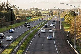
The Auckland Northern Motorway in the Auckland Region of New Zealand links central Auckland City and Puhoi in the former Rodney District via the Hibiscus Coast and North Shore. It is part of State Highway 1.

Northwestern Motorway road in New Zealand

The Northwestern Motorway, part of State Highway 16 (SH16), is the major western route and secondary northern route out of Auckland in New Zealand. Twenty-one kilometres in length, the motorway runs from Stanley St in Parnell through the Central Motorway Junction, and west through urban Auckland and Waitakere before continuing northwest and terminating outside of Kumeu. Its western terminus is at Brigham Creek Road in Whenuapai. A large part of it forms the middle section of the Western Ring Route.

Avondale–Southdown Line

The Avondale–Southdown Line is a proposed railway line between Avondale and Southdown in Auckland, New Zealand. One of its main functions would be to remove north–south freight trains from the section of the Auckland rail system that has the most passenger traffic.

New Zealand State Highway 2 road in New Zealand

State Highway 2 runs north–south through eastern parts of the North Island of New Zealand from the outskirts of Auckland to Wellington. It runs via Tauranga in the Bay of Plenty, Gisborne, and Napier and Hastings in Hawke's Bay. It is the second-longest highway in the North Island, after State Highway 1, which runs the length of both of the country's main islands.

New Zealand State Highway 18 road in New Zealand

State Highway 18 is a state highway that runs between the Auckland Northern Motorway on the North Shore and the Northwestern Motorway in Waitakere in Auckland, New Zealand. The Upper Harbour Motorway forms most of its length as of 2016. SH 18 forms the northern part of the Western Ring Route, which continues from Waitakere south-east to Manukau.

Northwestern Cycleway

The Northwestern Cycleway is a 12 km mostly off-road cycle route in New Zealand that connects the Auckland CBD in Auckland City with the suburb Henderson. For most of its length, it runs alongside the Northwestern Motorway.

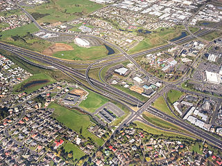
The Western Ring Route is a motorway system being constructed in Auckland, New Zealand. It currently runs along the entire Southwestern Motorway, most of the Northwestern Motorway, the entire Upper Harbour Motorway, and the entire Upper Harbour Highway. When the Upper Harbour Highway is upgraded to motorway status, the route will surpass the Southern Motorway to become the longest motorway in New Zealand at 48 kilometres in length. It runs through Manukau, Waitakere, and the North Shore, bypassing the Auckland city centre and thus providing a second motorway route through the Auckland isthmus.

Waikaraka Cycleway

The Waikaraka Cycleway is an off-road cycleway in the south of Auckland City, New Zealand, running from the Wesley suburb in southern Auckland City along New Zealand State Highway 20 to Onehunga and then continuing along the shoreline of the Manukau Harbour beside mostly industrialised areas until it ends at Hugo Johnston Drive, in Southdown.

Onehunga Harbour Road Bridge

The Onehunga Harbour Road Bridge is a walking and cycling bridge over Onehunga Harbour Road, a heavily trafficked road at the southwestern edge of Onehunga, New Zealand. The bridge provides easy and safe access from Onehunga to both the Waikaraka Cycleway running west-east, and Old Mangere Bridge to the south, which in turn links over the Mangere Inlet mouth of the Manukau Harbour. The bridge is 3.5m wide, and distinguished by its sweeping, curved structure.

The Western Corridor is a road in Christchurch, New Zealand which connects the suburb of Belfast, New Zealand in the north to Hornby in the south and connects the Canterbury region to Christchurch Airport. Most of the traffic on the corridor heads to the city, the airport, Belfast or Hornby, while 15% of traffic travels further north or south.

Auckland Airport Line

The Auckland Airport Line is a proposed railway line in Auckland, New Zealand, that would link Auckland Airport with the Auckland central business district via central isthmus suburbs.

Waterview Tunnel Road tunnel in Auckland, New Zealand

The Waterview Tunnel is a twin road tunnel in west Auckland, New Zealand. At 2,400 metres (7,900 ft) long, it is New Zealand's longest road tunnel. The tunnel, with three lanes of road vehicle traffic in each direction, connects State Highway 20 in the south at Mount Roskill to State Highway 16 in the west at Point Chevalier as part of the Waterview Connection. Its opening completed the Western Ring Route motorway system.

References

  1. 1 2 "Waterview Connection". NZTA.
  2. "SH20A improvements to airport journeys now open to traffic". NZ Transport Agency. 29 August 2017. Retrieved 3 September 2017.
  3. "Friday night transformation of intersection on SH20A to Auckland airport". NZ Transport Agency. 17 May 2018. Retrieved 20 May 2018.
  4. Dearnaley, Mathew (18 May 2009). "Another piece slots into city's commuter jigsaw". The New Zealand Herald. Retrieved 5 March 2010.
  5. "SH20-1 Manukau Extension". NZTA.
  6. "Western ring route progressing". The New Zealand Herald . 7 June 2010. Retrieved 9 July 2010.
  7. "Mangere Bridge Opened Today". The New Zealand Herald. 25 July 2010. Retrieved 1 August 2010.
  8. "Auckland's Waterview Tunnel open to traffic at last". Stuff.co.nz. 2 July 2017. Retrieved 2 July 2017.