
Great Western Highway is a 202-kilometre-long (126 mi) state highway in New South Wales, Australia. From east to west, the highway links Sydney with Bathurst, on the state's Central Tablelands.
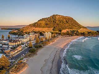
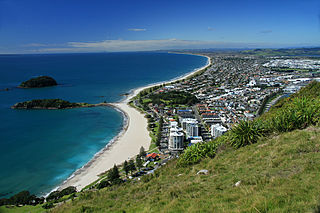
Mount Maunganui is a major residential, commercial and industrial suburb of Tauranga located on a peninsula to the north-east of Tauranga's city centre. It was an independent town from Tauranga until the completion of the Tauranga Harbour Bridge in 1988, which connects Mount Maunganui to Tauranga's central business district.

The Bolte Bridge is a large twin cantilever road bridge in Melbourne, Victoria, Australia. The Bolte Bridge carries a total of eight lanes of traffic – four lanes northbound and four lanes southbound. While officially only 490 metres in length, the actual structure appears much longer as it forms part of a 5 kilometre elevated roadway between Flemington Road and the West Gate Freeway. It spans the Yarra River and Victoria Harbour in the Docklands precinct to the west of the Melbourne CBD. It forms part of the CityLink system of toll roads that connects the Tullamarine Freeway from the northern suburbs with the West Gate Freeway and the Domain and Burnley tunnels to the Monash Freeway and the south eastern suburbs. It is named after Victoria's 38th and longest-serving Premier, Sir Henry Bolte.
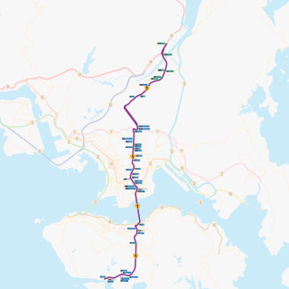
Route 1 is a major artery in Hong Kong that runs in a generally north-south direction, connecting Aberdeen with Sha Tin.
The M1 De Villiers Graaff motorway is a metropolitan route and major freeway in the City of Johannesburg, South Africa. The highway connects the southern areas with the city centre and extends further north through Sandton into the Ben Schoeman Highway towards Pretoria. Construction began in 1962 and resulted in the demolition of many properties and houses including numerous historical Parktown Mansions.
The M2 is a major highway and metropolitan route in Greater Johannesburg, South Africa. It is named the Francois Oberholzer Freeway. It runs just to the south of the Johannesburg Central Business District eastwards where it connects with the N3 and enters Germiston, ending near its CBD. The north–south M1 intersects with the M2 just to the south-west of the Johannesburg CBD.
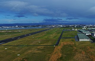
Tauranga Airport is an airport serving the city of Tauranga, New Zealand. It is located adjacent to Tauranga Harbour in the suburb of Mount Maunganui, approximately 3 km northeast of Tauranga CBD. The terminal is located to the north of the runway, on Jean Batten Drive, and consists of a two-storey building with four tarmac gates. Air New Zealand serves the airport through its subsidiaries Mount Cook Airline and Air Nelson, with flights to Auckland, Wellington and Christchurch. A further two regional airlines also operate to the airport, as well as scenic and charter flights, skydiving operations and general aviation.
Transport in Auckland, New Zealand's largest city, is defined by factors that include the shape of the Auckland isthmus, the suburban character of much of the urban area, a history of focusing investment on roading projects rather than public transport, and high car-ownership rates.

Western Distributor is a 4.3-kilometre-long (2.7 mi) grade-separated motorway that is primarily elevated for the majority of its route on the western fringe of the Sydney central business district in New South Wales, Australia. It links the southern end of Bradfield Highway at the Sydney Harbour Bridge to Victoria Road in Rozelle, at its western terminus near White Bay. It is a constituent part of the A4 route.
Sydney Bypass refers to a number of roads, existing and proposed, that motorists can use to avoid the congested approaches to the Sydney central business district (CBD). The main bypasses are:

The Auckland Northern Motorway in the Auckland Region of New Zealand links Central Auckland and Warkworth in the former Rodney District via the Hibiscus Coast and North Shore. It is part of State Highway 1.

The Hillsborough River Bridge is a bridge crossing the Hillsborough River estuary between Charlottetown and Stratford in Queens County, Prince Edward Island. The current road bridge, built in 1962, replaced a 1905 rail bridge crossing the same span which was known by the same name.

State Highway 2 runs north–south through eastern parts of the North Island of New Zealand from the outskirts of Auckland to Wellington. It runs through Tauranga, Gisborne, Napier, Hastings and Masterton. It is the second-longest highway in the North Island, after State Highway 1, which runs the length of both of the country's main islands.

The Second Harbour Crossing is the name given to the proposed second transport link across the Waitematā Harbour in Auckland, New Zealand. Planners have also referred to new links across the harbour as the Additional Waitematā Harbour Crossing (AWHC) or the Waitematā Harbour Connections.

Tauranga Harbour is the natural tidal harbour that surrounds Tauranga CBD and the Mount Maunganui area of Tauranga, New Zealand, and which flows into the Pacific Ocean at Mount Maunganui. The harbour is effectively two flooded river systems separated from the Pacific Ocean by Matakana Island.
The Mount Maunganui branch is a short industrial branch line in Tauranga, New Zealand, servicing the eastern side of the Port of Tauranga. It branches from the East Coast Main Trunk at a triangle junction outside Baypark Stadium before running north-west through Mount Maunganui to the port complex.
Tauranga is a coastal city in the Bay of Plenty Region and the fifth-most populous city of New Zealand, with an urban population of 161,800, or roughly 3% of the national population. It was settled by Māori late in the 13th century, colonised by Europeans in the early 19th century, and was constituted as a city in 1963.
The Maungatapu Bridge is a beam bridge which crosses the Tauranga Harbour and connects the Matapihi and Maungatapu peninsulas in New Zealand. The bridge opened in 1959 and is 316 metres long and 10 metres wide. The bridge carries two lanes of traffic and a footpath. Prior to 2009 State Highway 2 and State Highway 29 ran concurrently over the bridge. Following the completion of the Harbour Link project, State Highway 2 was diverted over the Tauranga Harbour Bridge, so at the present time only State Highway 29A runs over the bridge.

State Highway 29 (SH 29) is a New Zealand state highway that travels over the Kaimai Ranges linking the Bay of Plenty and Waikato regions. For most of its length, SH 29 is a two-lane single carriageway with occasional passing lanes and slow vehicle bays. 5 km of it near its eastern terminus is part of the Takitimu Drive Toll Road.

