
Napier is a New Zealand city with a seaport, located in Hawke's Bay on the eastern coast of the North Island. The population of Napier is about 63,900 as of the June 2018. About 18 kilometres (11 mi) south of Napier is the inland city of Hastings. These two neighbouring cities are often called "The Bay Cities" or "The Twin Cities" of New Zealand. The total population of the Napier-Hastings Urban Area is 134,500 people, which makes it the sixth-largest urban area in New Zealand, closely followed by Dunedin (122,000), and trailing Tauranga (141,600).

Hastings is a New Zealand city and is one of the two major urban areas in Hawke's Bay, on the east coast of the North Island of New Zealand. The population of Hastings is 70,600, with 45,000 living in the contiguous city and Flaxmere, 13,950 in Havelock North, 2,210 in Clive, and the remainder in the peri-urban area around the city. Hastings is about 18 kilometres inland of the coastal city of Napier. These two neighbouring cities are often called "The Bay Cities" or "The Twin Cities".
The New Zealand state highway network is the major national highway network in New Zealand. Nearly 100 roads in the North and South Islands are state highways. All state highways are administered by the NZ Transport Agency.

Taradale is a suburb of the City of Napier, in the Hawke's Bay Region of the North Island of New Zealand. It is a predominantly middle-upper class residential suburb, located 10 kilometres southwest of the centre of Napier. Its population was 10,659 in the 2013 Census, an increase of 270 from 2006.. The Taradale ward including the areas of Greenmeadows, Meeanee, and Poraiti, is an estimated population of 20,910.

The Napier-Hastings Urban Area lies mostly on the Heretaunga Plains of the Hawke's Bay Region in New Zealand and is a conurbation surrounding the twin cities of Napier and Hastings. It is the sixth most populous urban area in the country, with 134,500 residents, just slightly fewer than Tauranga (141,600) and more than Dunedin (122,000).

State Highway 1 is the longest and most significant road in the New Zealand road network, running the length of both main islands. It appears on road maps as SH 1 and on road signs as a white number 1 on a red shield, but it has the official designations SH 1N in the North Island, SH 1S in the South Island.
State Highway 20, also known as the Southwestern Motorway, is a New Zealand state highway linking State Highway 1 at Manukau City Centre with State Highway 16 in Point Chevalier, via Mangere and Onehunga. Along with its spurs, State Highway 20A and 20B, the state highway serves Auckland Airport, the country's largest, therefore making State Highway 20 a key arterial route connecting the airport to the wider Auckland region and most of the upper North Island. The route also forms the southern part of the Western Ring Route, a 48 kilometres (30 mi) motorway route bypassing central Auckland. It is the only New Zealand State Highway that is entirely motorway.

State Highway 5 is the second shortest of New Zealand's eight national highways. It extends from SH 1 at Tirau, on the plains of the Waikato River, to SH 2, close to the Hawke Bay coast at Bay View, 10 km north of Napier. Distances are measured from north to south.

State Highway 2 runs north–south through eastern parts of the North Island of New Zealand from the outskirts of Auckland to Wellington. It runs via Tauranga in the Bay of Plenty, Gisborne, and Napier and Hastings in Hawke's Bay. It is the second-longest highway in the North Island, after State Highway 1, which runs the length of both of the country's main islands.
The Waikato Expressway is a dual carriageway section of State Highway 1 in the Waikato region of the North Island of New Zealand that is being constructed in stages. It forms part of the link between Auckland and Hamilton. When completed it will stretch 116 km (72 mi) and be 6 km (3.7 mi) shorter than the roads it replaced.
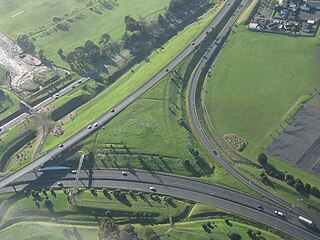
The Hawke's Bay Expressway, known also as the Napier-Hastings Expressway, runs from Hawke's Bay Airport passing through Napier and Taradale, west of Hastings, and ends at Pakipaki just south of Hastings, a total length of 24km.
The Tauranga Eastern Link (TEL) is a four lane motorway in the Bay of Plenty region in New Zealand, covering 23 km from Te Maunga junction in Tauranga to Paengaroa. It was officially opened on 30 July 2015. It replaced a section of State Highway 2, improving access to Tauranga from the east and south. It became the main route for trucks heading to the Port of Tauranga from Rotorua and the eastern Bay of Plenty, and connected the Central Plateau forestry industry with the port to facilitate lumber export.
State Highway 74 is a state highway in New Zealand servicing the eastern suburbs of Christchurch. Mostly two-lane, it is composed of limited-access expressways, with part of the highway as the Christchurch-Lyttelton Motorway, and connects the city to its port town of Lyttelton.

State Highway 57 is a New Zealand state highway, linking State Highway 1 north of Ohau to State Highway 3 east of Ashhurst, via Levin, Shannon, Massey University and the southern suburbs of Palmerston North. The highway connects State Highway 1 traffic coming north from Wellington to the city of Palmerston North, and further to the Manawatu Gorge, allowing passage to the eastern side of the North Island and to the twin cities of Napier and Hastings. The highway is classified by the NZTA as a national strategic road.
State Highway 50 (SH 50) is a New Zealand state highway that runs through the Hawke's Bay Region.
State Highway 39 (SH 39) is a New Zealand state highway that forms a western bypass of the city of Hamilton. Gazetted in 1999, it is a generally quicker route to get between Auckland and New Plymouth as well as connecting to the Waitomo Caves, just south of the SH 39 southern terminus. The southernmost 14 km section has a concurrency with SH 31, as this highway has existed for much longer.
State Highway 15 (SH 15) is a New Zealand state highway in the Northland region of the North Island. It is 126.5 km long and provides an alternative route to SH 1 between the Kaikohe and Whangarei areas; a spur also links SH 1 with the Marsden Point Oil Refinery and Northport.
State Highway 36 (SH 36) is a New Zealand state highway in the Bay of Plenty region in the North Island. It is one of two state highways that form a north-south connection between the cities of Tauranga and Rotorua, SH 36 being the most westerly of the two. It was identified as a quicker route to access the two cities and extensive work was done to upgrade the rural route to state highway quality.
