Blenheim is the most populous town in the region of Marlborough, in the north east of the South Island of New Zealand. It has an urban population of 31,600. The surrounding area is well known as the centre of New Zealand's wine industry. It enjoys one of New Zealand's sunniest climates, with warm, relatively dry summers and cool, crisp winters.

Saint Arnaud is a small alpine village located in the north of New Zealand's South Island, west of the mountains of the Saint Arnaud Range and 90 kilometres southwest of Nelson near the historic Tophouse Settlement. It is situated at the northern end of Lake Rotoiti.

State Highway 1 is the longest and most significant road in the New Zealand road network, running the length of both main islands. It appears on road maps as SH 1 and on road signs as a white number 1 on a red shield, but it has the official designations SH 1N in the North Island, SH 1S in the South Island.
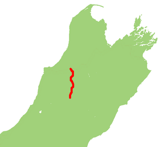
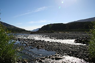
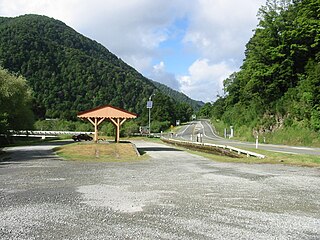
State Highway 65 is a New Zealand state highway in the South Island. It is 71 km long and runs south to north down the Maruia river valley from SH 7 at Springs Junction, 15 km west of the main divide at the Lewis Pass, to SH 6 in the Buller Gorge, 11 km west of Murchison. It forms part of the most direct route between Christchurch and Nelson. It takes its name from a small settlement toward its northern end.
Tophouse, also known as Tophouse Settlement, is a rural locality in the Tasman District of New Zealand's South Island, some 8 km northeast of Saint Arnaud. It is named after a hotel established in the 19th century to service drovers transporting their sheep between Canterbury and Marlborough. The hotel is still in operation today and has an eventful history, including a double murder suicide in October 1894. For many years, "Tophouse" referred specifically to the hotel, but it has also been used to refer to the general vicinity, and on 20 February 2001, the New Zealand Geographic Board assigned the name "Tophouse Settlement" to the area.
There have been various proposals to link the city of Nelson to New Zealand’s South Island rail network, but none have come to fruition.

State Highway 7 is a major New Zealand state highway. One of the eight national highways, it crosses the Southern Alps to link the West Coast Region with Canterbury and to form a link between the South Island's two longest highways, State Highway 1 and State Highway 6. Distances are measured from east to west with the major junction list going from east to west.

State Highway 4 is the shortest of New Zealand's eight national highways. It runs north-south across rugged hill country, forming a short cut between two points on State Highway 3 thereby avoiding Taranaki and the coasts of the North and South Taranaki Bights. Distances are measured from north to south.
Kawatiri railway station was a rural railway station that served the small settlement of Kawatiri in the Tasman District of New Zealand’s South Island. Kawatiri is located on State Highway 6 at the junction with State Highway 63. It was one of 25 stations on the Nelson Section, and marked the furthest extent of Railways Department operations on the line. Kawatiri was one of the shortest-lived stations operated by the Railways Department: 5 years, 21 days between 1926 and 1931.
State Highway 80 is a South Island state highway in New Zealand. Known as Mount Cook Road, it is a tourist road between the settlements of Twizel and Mount Cook Village. About 55 kilometres in length, it is mostly two lane, with a few single-lane bridges. Tourists travelling between Christchurch and Queenstown often deviate here and travel to New Zealand's highest mountain Aoraki/Mount Cook.

State Highway 87 is a state highway in New Zealand servicing the Taieri Plains and the Strath-Taieri Valley in Otago, connecting Mosgiel to Kyeburn on the eastern flank of the Maniototo Plains.

State Highway 60 is a state highway servicing the far northwest of the South Island of New Zealand. Running between the settlements of Richmond and Collingwood, it is 116 kilometres (72 mi) long and lies entirely within the Tasman District. It is the northernmost highway in the South Island and is a popular tourist route, servicing Motueka, Abel Tasman National Park, Golden Bay, and Farewell Spit.
State Highway 62 is a state highway servicing the northeastern parts of the South Island of New Zealand. Located entirely within the wine-producing Marlborough region of New Zealand, SH 62 provides a northern bypass of Blenheim, connecting the towns of Spring Creek with Renwick via the locality of Rapaura.
State Highway 25 is a North Island state highway in New Zealand that loops around the Coromandel Peninsula. It is a major route for holidaymakers and tourists which has access to some of New Zealand's most idyllic beach holiday spots. The summer period around Christmas and New Year's Eve is a particularly busy period for the highway. The road is very scenic, but also windy in many parts as well as single carriage on the entire route, and is prone to accidents. It is New Zealand's third longest two-digit state highway, after SH 35 and SH 94. It is part of the Pacific Coast Highway.
State Highway 61 (SH 61) is a former New Zealand state highway in the Tasman Region of the South Island. It links the coastal town of Motueka with SH 6, the main route to the South Island's West Coast. Along with several other state highways, its status was revoked at the beginning of the 1990s. The route is now usually referred to as the Motueka Valley Highway.
Ngāti Apa ki te Rā Tō is a Māori iwi (tribe) in the upper South Island of New Zealand. Its rohe include the areas around Golden Bay, Takaka, Tasman Bay, Motueka, Nelson and Saint Arnaud, including Taitapu and Kawatiri river catchments and Lakes Rotoiti, Rotoroa and the Tophouse.