New Zealand State Highway 65

Last updated

State Highway 65 NZ.svg

State Highway 65
NZ-SH 65 map.png
Route information
Maintained by NZ Transport Agency
Length 71.7 km (44.6 mi)
Major junctions
North end SH 6 near Murchison
South end SH 7 at Springs Junction
Location
Primary
destinations
Shenandoah, Maruia
Highway system
State Highway 63 NZ.svg SH 63 SH 67 State Highway 67 NZ.svg

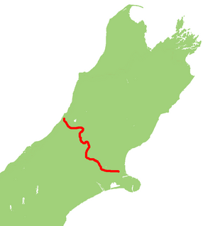
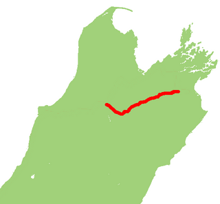
State Highway 65 (also known as the Shenandoah Highway) is a New Zealand state highway in the South Island. It is 71 km long and runs south to north down the Maruia river valley from SH 7 at Springs Junction, 15 km west of the main divide at the Lewis Pass, to SH 6 in the Buller Gorge, 11 km west of Murchison. It forms part of the most direct route between Christchurch and Nelson. It takes its name from a small settlement toward its northern end.

The New Zealand state highway network is the major national highway network in New Zealand. Nearly 100 roads in the North and South Islands are state highways. All state highways are administered by the NZ Transport Agency.

South Island Southernmost of the two main islands in New Zealand

The South Island, also officially named Te Waipounamu, is the larger of the two major islands of New Zealand in surface area; the other being the smaller but more populous North Island. It is bordered to the north by Cook Strait, to the west by the Tasman Sea, and to the south and east by the Pacific Ocean. The South Island covers 150,437 square kilometres (58,084 sq mi), making it the world's 12th-largest island. It has a temperate climate.

Springs Junction

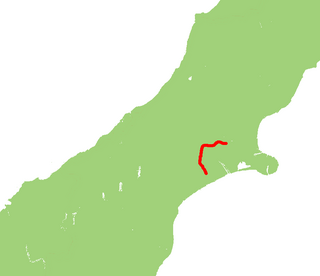
Springs Junction is a significant road junction in New Zealand that connects two major highways, State Highway 7 and State Highway 65.

Contents

The road is sealed and two-lane, with some single-lane bridges. The surrounding country is used for pastoral farming (beef and dairy) with some forestry on the surrounding hills. Springs Junction is the only locality with fuel or food along the route while Maruia is the largest settlement along the route.

Maruia Place in West Coast, New Zealand

Maruia is a locality in the West Coast region of New Zealand. The Shenandoah Highway passes through it. Murchison is 65 km north, the Lewis Pass is 39 km to the south-east, and Reefton is 63 km west by road. The Maruia River flows past to the west.

Maruia Falls following heavy rain. Maruia falls.jpg
Maruia Falls following heavy rain.

Maruia Falls, a 5-m waterfall near the road, did not exist prior to the 1929 Murchison earthquake (magnitude 7.8).

1929 Murchison earthquake earthquake

The 1929 Murchison earthquake occurred at 10:17 am on 17 June. It struck the Murchison region of the South Island, with an estimated magnitude of 7.3, and was felt throughout New Zealand. There were 17 casualties, mostly as a result of landslides triggered by the earthquake. The rumbling sound of the earthquake was loud enough to be heard at New Plymouth, more than 250 km (155 mi) away.

The surface wave magnitude scale is one of the magnitude scales used in seismology to describe the size of an earthquake. It is based on measurements in Rayleigh surface waves that travel primarily along the uppermost layers of the Earth. It is currently used in People's Republic of China as a national standard for categorising earthquakes.

See also

Related Research Articles

Maruia River river in New Zealand

The Maruia River is located in the northwestern South Island of New Zealand. It is a major tributary of the Buller River, flowing for 80 km before joining the larger river eight kilometres to the west of Murchison.

New Zealand State Highway 1 road in New Zealand

State Highway 1 is the longest and most significant road in the New Zealand road network, running the length of both main islands. It appears on road maps as SH 1 and on road signs as a white number 1 on a red shield, but it has the official designations SH 1N in the North Island, SH 1S in the South Island.

New Zealand State Highway 7 road in New Zealand

State Highway 7 is a major New Zealand state highway. One of the eight national highways, it crosses the Southern Alps to link the West Coast Region with Canterbury and to form a link between the South Island's two longest highways, State Highway 1 and State Highway 6. Distances are measured from east to west with the major junction list going from east to west.

New Zealand State Highway 6 road in New Zealand

State Highway 6 is a major New Zealand state highway. It extends from the northeastern corner of the South Island across the top of the island, then down the length of the island, initially along the West Coast and then across the Southern Alps through inland Otago and finally across the Southland Plains to the island's south coast. Distances are measured from north to south.

New Zealand State Highway 4 road in New Zealand

State Highway 4 is the shortest of New Zealand's eight national highways. It runs north-south across rugged hill country, forming a short cut between two points on State Highway 3 thereby avoiding Taranaki and the coasts of the North and South Taranaki Bights. Distances are measured from north to south.

New Zealand State Highway 2 road in New Zealand

State Highway 2 runs north–south through eastern parts of the North Island of New Zealand from the outskirts of Auckland to Wellington. It runs via Tauranga in the Bay of Plenty, Gisborne, and Napier and Hastings in Hawke's Bay. It is the second-longest highway in the North Island, after State Highway 1, which runs the length of both of the country's main islands.

U.S. Route 36 in Colorado highway in Colorado

U.S. Highway 36 is a major east–west route in the U.S. state of Colorado, extending from Rocky Mountain National Park to the Kansas state line.

New Zealand State Highway 73 road in New Zealand

State Highway 73 is a major east-west South Island state highway in New Zealand connecting Christchurch on the east coast with Cass/Hokitika via the Southern Alps. It is mostly two lane, with some single-lane bridges north of Springfield but is mostly dual carriageway in Christchurch. The fourth and fifth-highest points of New Zealand's state highway network are on this road at Porters Pass and Arthur's Pass respectively.

New Zealand State Highway 77 road in New Zealand

State Highway 77 is a state highway in New Zealand going through the inland parts of Central and Mid Canterbury between the towns of Ashburton and Darfield via the Rakaia Gorge. It is wholly single carriageway with two one-lane bridges at the Rakaia and Selwyn Rivers. One set of traffic lights is found in Ashburton marking the southern terminus of the highway.

New Zealand State Highway 63 road in New Zealand

State Highway 63 is a state highway located in the northern parts of the South Island of New Zealand. It is 117 km long and runs between the settlements of Renwick and Kawatiri Junction via Saint Arnaud, providing a bypass of the city of Nelson. Despite being a convenient link between the West Coast and Marlborough, and being a relatively straight highway along most of its length, it is only classified by the NZTA as a secondary collector highway.

New Zealand State Highway 87 road in New Zealand

State Highway 87 is a state highway in New Zealand servicing the Taieri Plains and the Strath-Taieri Valley in Otago, connecting Mosgiel to Kyeburn on the eastern flank of the Maniototo Plains.

New Zealand State Highway 29 road in New Zealand

State Highway 29 (SH 29) is a New Zealand state highway that travels over the Kaimai Ranges linking the Bay of Plenty and Waikato regions. For most of its length, SH 29 is a two-lane single carriageway with occasional passing lanes and slow vehicle bays. 5 km of it near its eastern terminus is part of the Takitimu Drive Toll Road.

State Highway 25 is a North Island state highway in New Zealand that loops around the Coromandel Peninsula. It is a major route for holidaymakers and tourists which has access to some of New Zealand's most idyllic beach holiday spots. The summer period around Christmas and New Year's Eve is a particularly busy period for the highway. The road is very scenic, but also windy in many parts as well as single carriage on the entire route, and is prone to accidents. It is New Zealand's third longest two-digit state highway, after SH 35 and SH 94. It is part of the Pacific Coast Highway.

State Highway 47 (SH 47) is a New Zealand state highway in the central North Island. It provides a link from SH 4 at National Park to SH 41 at Tokaanu just west of Turangi.

State Highway 15 (SH 15) is a New Zealand state highway in the Northland region of the North Island. It is 126.5 km long and provides an alternative route to SH 1 between the Kaikohe and Whangarei areas; a spur also links SH 1 with the Marsden Point Oil Refinery and Northport.

State Highway 36 (SH 36) is a New Zealand state highway in the Bay of Plenty region in the North Island. It is one of two state highways that form a north-south connection between the cities of Tauranga and Rotorua, SH 36 being the most westerly of the two. It was identified as a quicker route to access the two cities and extensive work was done to upgrade the rural route to state highway quality.

State Highway 61 (SH 61) is a former New Zealand state highway in the Tasman Region of the South Island. It links the coastal town of Motueka with SH 6, the main route to the South Island's West Coast. Along with several other state highways, its status was revoked at the beginning of the 1990s. The route is now usually referred to as the Motueka Valley Highway.

References