New Zealand State Highway 75

Last updated

State Highway 75 NZ.svg

State Highway 75
NZ-SH 75 map.png
Route information
Maintained by NZ Transport Agency
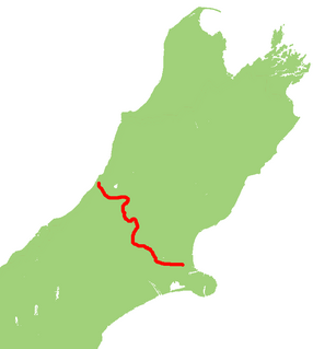
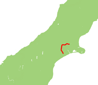
Length 76.9 km (47.8 mi)
Major junctions
Northwest end Curletts Road/Christchurch Southern Motorway State Highway 73 NZ.svg / State Highway 76 NZ.svg at Christchurch
Southeast endWoodills Road at Akaroa
Location
Primary
destinations
Halswell, Tai Tapu, Motukarara, Birdling's Flat, Little River, Cooptown, Duvauchelle, Takamatua
Highway system
State Highway 74 NZ.svg SH 74 SH 76 State Highway 76 NZ.svg

State Highway 75 (SH 75) is a state highway in New Zealand servicing the Banks Peninsula region, connecting Christchurch on the northwestern part of the peninsula with Akaroa towards the east coast. It is wholly two lane (with the exception of some passing lanes near Hilltop), but partially functions as a major arterial corridor of Christchurch. Its highest point is at Hilltop, where it rises to about 555 m - just 8 m lower than the more mountainous Haast Pass in the Southern Alps.

The New Zealand state highway network is the major national highway network in New Zealand. Nearly 100 roads in the North and South Islands are state highways. All state highways are administered by the NZ Transport Agency.

Banks Peninsula peninsula in New Zealand

Banks Peninsula is a peninsula of volcanic origin on the east coast of the South Island of New Zealand. It has an area of approximately 1,150 square kilometres (440 sq mi) and encompasses two large harbours and many smaller bays and coves. The South Island's largest city, Christchurch, is immediately north of the peninsula.

Christchurch Metropolitan area in South Island, New Zealand

Christchurch is the largest city in the South Island of New Zealand and the seat of the Canterbury Region. The Christchurch urban area lies on the South Island's east coast, just north of Banks Peninsula. It is home to 404,500 residents, making it New Zealand's third-most populous city behind Auckland and Wellington. The Avon River flows through the centre of the city, with an urban park located along its banks.

Contents

SH 75 is the longest state highway with no connections to any of the eight main single-digit state highways. This hasn't always been the case as SH 75 used to terminate with SH 1 when it ran through central Christchurch. This title was eclipsed from SH 32 in the North Island (which has since been extended to SH 1N).

New Zealand State Highway 1 road in New Zealand

State Highway 1 is the longest and most significant road in the New Zealand road network, running the length of both main islands. It appears on road maps as SH 1 and on road signs as a white number 1 on a red shield, but it has the official designations SH 1N in the North Island, SH 1S in the South Island.

State Highway 32 (SH 32) is a New Zealand state highway in the Central North Island. It forms part of a western traverse of Lake Taupo and a less busy alternative to SH 1, avoiding Taupo.

Route

As of January 2013, this is the current route of the highway: [1]

The highway currently begins at the intersection of Curletts Road and Christchurch Southern Motorway (the former SH 73, the latter SH 76) which is now a dogbone interchange. At Curletts Road, the road proceeds as a short expressway to the southeast until it reaches the intersection of Hoon Hay Road and Halswell Road. SH 75 turns right onto Halswell Road, and continues in a southwesterly direction until it just passes the settlement of Halswell.

The Christchurch Southern Motorway is a motorway to the south-west of Christchurch, New Zealand linking the inner-city suburb of Addington to the southern suburb of Hornby. The motorway, which is approximately 7.5 km long and is four-lane divided, forms part of State Highway 76.

New Zealand State Highway 73 road in New Zealand

State Highway 73 is a major east-west South Island state highway in New Zealand connecting Christchurch on the east coast with Cass/Hokitika via the Southern Alps. It is mostly two lane, with some single-lane bridges north of Springfield but is mostly dual carriageway in Christchurch. The fourth and fifth-highest points of New Zealand's state highway network are on this road at Porters Pass and Arthur's Pass respectively.

State Highway 76 (SH 76) is a state highway in Christchurch, New Zealand. This highway was gazetted in 2012 after stage 1 of the Christchurch Southern Motorway was completed. Beforehand, much of SH 76 was part of SH 73 and included the former two-lane Christchurch Arterial Motorway, which was upgraded to four lanes. SH 76 includes the entire length of the Christchurch Southern Motorway and forms the most direct route from the south of Christchurch to the city centre and Lyttelton.

Now known Tai Tapu Road, the road skirts the outer edges of Banks Peninsula while passing through arable farmland to reach the settlement of Tai Tapu. The road then changes name to Christchurch Akaroa Highway while continuing to skirt between Lake Ellesmere and the hills until Birdling's Flat, where it turns sharply into the hills of Banks Peninsula while hugging the shore of Lake Forsyth. The road proceeds through Western Valley to Little River and Cooptown.

Tai Tapu Place in South Island, New Zealand

Tai Tapu is a large rural area with a small village adjacent to the Halswell River and nestled in the Port Hills, located 6 km east of the town of Lincoln and 18 km south west of Christchurch in the Canterbury region of New Zealand's South Island. State Highway 75 passes through the centre of the village, connecting Christchurch with Akaroa and the Banks Peninsula.

Birdlings Flat settlement on Banks Peninsula, New Zealand

Birdling's Flat, originally named Te Mata Hapuku, is a settlement in Canterbury, New Zealand, close to the shore of Lake Ellesmere / Te Waihora.

Lake Forsyth lake in New Zealand

Lake Forsyth is a lake in the Canterbury region of New Zealand.

After Cooptown, the road then begins to climb in a zigzag fashion towards Hilltop Saddle, which is frequently covered under snow during winter cold fronts. After Hilltop, the road descends in a similar fashion onto Akaroa Harbour at Barry's Bay. The road then hugs the shoreline as it passes through Duvauchelle and Takamatua before descending into Akaroa, terminating just before the Woodills Road/Rue Lavaud intersection.

Akaroa Harbour harbor in New Zealand

Akaroa Harbour is part of Banks Peninsula in the Canterbury Region of New Zealand.

Duvauchelle settlement on Banks Peninsula, New Zealand

Duvauchelle is a small town situated at the head of Akaroa Harbour on Banks Peninsula in New Zealand. State Highway 75 passes through the town. The Onawe Peninsula separates Duvauchelle bay from Barry's Bay.

Route changes

In the early 1990s when SH 1 used to travel through central Christchurch, via Moorhouse Avenue, SH 75 covered the entire length of Lincoln Road and terminated there. When SH 1 was re-routed to the west of Christchurch, SH 75 was altered to its current route, terminating with the Christchurch Arterial Motorway (now the Christchurch Southern Motorway). The motorway at the same time became the new route for SH 73.

SH 75 used to travel down Rue Lavaud and Beach Road, terminating in the township of Akaroa. This has since been curtailed back. The former state highway section of Beach Road was redeveloped in the early 2000s. [2]

See also

Related Research Articles

Halswell Place

Halswell is a suburb of Christchurch, New Zealand, located in open country 9 kilometres (5.6 mi) southwest of Cathedral Square on State Highway 75. A residential town, it has little in the way of its own industry and acts as an outer dormitory satellite town.

New Zealand State Highway 20 road in New Zealand

State Highway 20, also known as the Southwestern Motorway, is a New Zealand state highway linking State Highway 1 at Manukau City Centre with State Highway 16 in Point Chevalier, via Mangere and Onehunga. Along with its spurs, State Highway 20A and 20B, the state highway serves Auckland Airport, the country's largest, therefore making State Highway 20 a key arterial route connecting the airport to the wider Auckland region and most of the upper North Island. The route also forms the southern part of the Western Ring Route, a 48 kilometres (30 mi) motorway route bypassing central Auckland. It is the only New Zealand State Highway that is entirely motorway.

New Zealand State Highway 4 road in New Zealand

State Highway 4 is the shortest of New Zealand's eight national highways. It runs north-south across rugged hill country, forming a short cut between two points on State Highway 3 thereby avoiding Taranaki and the coasts of the North and South Taranaki Bights. Distances are measured from north to south.

New Zealand State Highway 16 road in New Zealand

State Highway 16 is a New Zealand state highway linking central Auckland with Wellsford, via Auckland's Northwestern Motorway, Helensville and Kaukapakapa. It provides an alternative to State Highway 1 for traffic travelling between Auckland and parts of Northland from Wellsford northwards.

The Christchurch–Lyttelton Motorway, also known as Tunnel Road, is part of the road network connecting Christchurch, New Zealand with its port at Lyttelton.

The Christchurch Northern Motorway is a motorway north of Christchurch, New Zealand, linking the northern Christchurch suburb of Belfast with Pineacres, between Woodend and Kaiapoi, bypassing the Kaiapoi area. The motorway is 10.2 kilometres (6.3 mi) in length, and is four-lane divided except for the two-lane undivided section between the Lineside Road/Smith Street interchange and the northern terminus. The motorway forms part of State Highway 1. The southern end of the motorway is being extended to QEII Drive in the Christchurch suburb of Mairehau; this extension forms part of State Highway 74.

State Highway 74 is a state highway in New Zealand servicing the eastern suburbs of Christchurch. Mostly two-lane, it is composed of limited-access expressways, with part of the highway as the Christchurch-Lyttelton Motorway, and connects the city to its port town of Lyttelton.

New Zealand State Highway 77 road in New Zealand

State Highway 77 is a state highway in New Zealand going through the inland parts of Central and Mid Canterbury between the towns of Ashburton and Darfield via the Rakaia Gorge. It is wholly single carriageway with two one-lane bridges at the Rakaia and Selwyn Rivers. One set of traffic lights is found in Ashburton marking the southern terminus of the highway.

State Highway 17 was the designation for a 32-kilometre stretch of highway in northern Auckland in the North Island of New Zealand from December 1999 to October 2012. It is now designated Urban Route 31 and consists of the Hibiscus Coast Highway, Dairy Flat Highway and Albany Expressway. It linked State Highway 1 at Puhoi in the north with SH 1 at Albany in the south. Its main destinations were the towns of Waiwera, Orewa, Red Beach, Whangaparaoa, Silverdale, Dairy Flat and the suburb of Albany. Prior to its inception as SH 17, the road was part of SH 1, and was redesignated as SH 17 as the Northern Motorway was extended northwards and took over the designation of SH 1.

New Zealand State Highway 60 road in New Zealand

State Highway 60 is a state highway servicing the far northwest of the South Island of New Zealand. Running between the settlements of Richmond and Collingwood, it is 116 kilometres (72 mi) long and lies entirely within the Tasman District. It is the northernmost highway in the South Island and is a popular tourist route, servicing Motueka, Abel Tasman National Park, Golden Bay, and Farewell Spit.

The Western Belfast Bypass is an approximately five-kilometre-long (3.1 mi), four lane, grade separated motorway recently built to bypass the northern Christchurch suburb of Belfast, New Zealand. It is estimated that its construction will result in 17,000 fewer vehicles using Main North Road through Belfast, and shorten travel times between the north and west of Christchurch. In addition, the motorway will allow for improved public transport, cycling, and pedestrian options on Main North Road. It is expected that 21,500 vehicles per day will use the WBB motorway by 2026. The speed limit along the route will be 100 km/h.

State Highway 22 (SH 22) is a New Zealand state highway just south of Auckland. It connects the town of Pukekohe to the Auckland Southern Motorway.

State Highway 25 is a North Island state highway in New Zealand that loops around the Coromandel Peninsula. It is a major route for holidaymakers and tourists which has access to some of New Zealand's most idyllic beach holiday spots. The summer period around Christmas and New Year's Eve is a particularly busy period for the highway. The road is very scenic, but also windy in many parts as well as single carriage on the entire route, and is prone to accidents. It is New Zealand's third longest two-digit state highway, after SH 35 and SH 94. It is part of the Pacific Coast Highway.

References

  1. State Highway 75 on Google Maps
  2. "Akaora Historical Overview (pt.2)" (PDF). Christchurch City Council. Retrieved 17 March 2016.