
State Highway 1 is the longest and most significant road in the New Zealand road network, running the length of both main islands. It appears on road maps as SH 1 and on road signs as a white number 1 on a red shield, but it has the official designations SH 1N in the North Island, SH 1S in the South Island.
The Central Motorway Junction or CMJ, is the intersection of State Highways 1 and 16, just south of the central business district of Auckland. A multilevel structure, it has been described as a "fiendishly complicated, multi-layered puzzle of concrete, steel and asphalt". Carrying around 200,000 vehicles a day, it is one of the busiest stretches of road in New Zealand.
Transport in Auckland, New Zealand's largest city, is defined by factors that include the shape of the Auckland isthmus, the suburban character of much of the urban area, a history of focusing investment on roading projects rather than public transport, and high car-ownership rates.

The Auckland Northern Motorway in the Auckland Region of New Zealand links central Auckland City and Puhoi in the former Rodney District via the Hibiscus Coast and North Shore. It is part of State Highway 1.
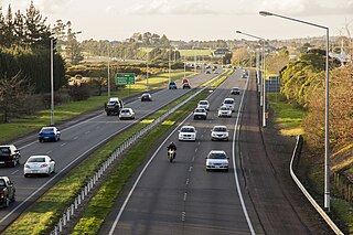
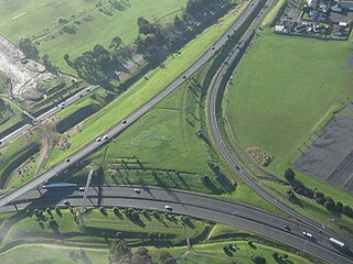
The Auckland Southern Motorway is the major route south out of the Auckland Region of New Zealand. It is part of State Highway 1.

The Northwestern Motorway, part of State Highway 16 (SH16), is the major western route and secondary northern route out of Auckland in New Zealand. Twenty-one kilometres in length, the motorway runs from Stanley St in Parnell through the Central Motorway Junction, and west through urban Auckland and Waitakere before continuing northwest and terminating outside of Kumeu. Its western terminus is at Brigham Creek Road in Whenuapai. A large part of it forms the middle section of the Western Ring Route.
State Highway 20, also known as the Southwestern Motorway, is a New Zealand state highway linking State Highway 1 at Manukau City Centre with State Highway 16 in Point Chevalier, via Mangere and Onehunga. Along with its spurs, State Highway 20A and 20B, the state highway serves Auckland Airport, the country's largest, therefore making State Highway 20 a key arterial route connecting the airport to the wider Auckland region and most of the upper North Island. The route also forms the southern part of the Western Ring Route, a 48 kilometres (30 mi) motorway route bypassing central Auckland. It is the only New Zealand State Highway that is entirely motorway.

The Victoria Park Viaduct is a major motorway viaduct carrying the Auckland Northern Motorway over the Victoria Park area in Auckland City, New Zealand. Construction began in 1959, and the bridge was opened on 5 April 1962.

State Highway 2 runs north–south through eastern parts of the North Island of New Zealand from the outskirts of Auckland to Wellington. It runs via Tauranga in the Bay of Plenty, Gisborne, and Napier and Hastings in Hawke's Bay. It is the second-longest highway in the North Island, after State Highway 1, which runs the length of both of the country's main islands.

State Highway 18 is a state highway that runs between the Auckland Northern Motorway on the North Shore and the Northwestern Motorway in Waitakere in Auckland, New Zealand. The Upper Harbour Motorway forms most of its length as of 2016. SH 18 forms the northern part of the Western Ring Route, which continues from Waitakere south-east to Manukau.
The Ngauranga Interchange is a major interchange in the suburb of Ngauranga, in Wellington City, New Zealand. The Ngauranga interchange connects State Highways 1 and 2 with each other and also to Hutt Road for access to the interisland ferry terminals and alternative access to Wellington City. The majority of traffic in and out of Wellington City uses this interchange.
The Western Ring Route is a motorway system being constructed in Auckland, New Zealand. It currently runs along the entire Southwestern Motorway, most of the Northwestern Motorway, the entire Upper Harbour Motorway, and the entire Upper Harbour Highway. When the Upper Harbour Highway is upgraded to motorway status, the route will surpass the Southern Motorway to become the longest motorway in New Zealand at 48 kilometres in length. It runs through Manukau, Waitakere, and the North Shore, bypassing the Auckland city centre and thus providing a second motorway route through the Auckland isthmus.

State Highway 75 (SH 75) is a state highway in New Zealand servicing the Banks Peninsula region, connecting Christchurch on the northwestern part of the peninsula with Akaroa towards the east coast. It is wholly two lane, but partially functions as a major arterial corridor of Christchurch. Its highest point is at Hilltop, where it rises to about 555 m - just 8 m lower than the more mountainous Haast Pass in the Southern Alps.
State Highway 17 was the designation for a 32-kilometre stretch of highway in northern Auckland in the North Island of New Zealand from December 1999 to October 2012. It is now designated Urban Route 31 and consists of the Hibiscus Coast Highway, Dairy Flat Highway and Albany Expressway. It linked State Highway 1 at Puhoi in the north with SH 1 at Albany in the south. Its main destinations were the towns of Waiwera, Orewa, Red Beach, Whangaparaoa, Silverdale, Dairy Flat and the suburb of Albany. Prior to its inception as SH 17, the road was part of SH 1, and was redesignated as SH 17 as the Northern Motorway was extended northwards and took over the designation of SH 1.

State Highway 87 is a state highway in New Zealand servicing the Taieri Plains and the Strath-Taieri Valley in Otago, connecting Mosgiel to Kyeburn on the eastern flank of the Maniototo Plains.

State Highway 29 (SH 29) is a New Zealand state highway that travels over the Kaimai Ranges linking the Bay of Plenty and Waikato regions. For most of its length, SH 29 is a two-lane single carriageway with occasional passing lanes and slow vehicle bays. 5 km of it near its eastern terminus is part of the Takitimu Drive Toll Road.
State Highway 76 (SH 76) is a state highway in Christchurch, New Zealand. This highway was gazetted in 2012 after stage 1 of the Christchurch Southern Motorway was completed. Beforehand, much of SH 76 was part of SH 73 and included the former two-lane Christchurch Arterial Motorway, which was upgraded to four lanes. SH 76 includes the entire length of the Christchurch Southern Motorway and forms the most direct route from the south of Christchurch to the city centre and Lyttelton.
State Highway 22 (SH 22) is a New Zealand state highway just south of Auckland. It connects the town of Pukekohe to the Auckland Southern Motorway.
State Highway 23 (SH 23) is a New Zealand state highway that connects the towns of Raglan and Hamilton.

