
The Auckland Harbour Bridge is an eight-lane motorway bridge over the Waitematā Harbour in Auckland, New Zealand. It joins St Marys Bay on the Auckland city side with Northcote on the North Shore side. It is part of State Highway 1 and the Auckland Northern Motorway. The bridge is operated by the NZ Transport Agency (NZTA). It is the second-longest road bridge in New Zealand, and the longest in the North Island.

Māngere Bridge, officially also called the Manukau Harbour Crossing, is a dual motorway bridge over the Manukau Harbour in south-western Auckland, New Zealand, crossing between the suburb also known as Māngere Bridge and the suburb of Onehunga.

State Highway 1 is the longest and most significant road in the New Zealand road network, running the length of both main islands. It appears on road maps as SH 1 and on road signs as a white number 1 on a red shield, but it has the official designations SH 1N in the North Island, SH 1S in the South Island.
Transport in Auckland, New Zealand's largest city, is defined by factors that include the shape of the Auckland isthmus, the suburban character of much of the urban area, a history of focusing investment on roading projects rather than public transport, and high car-ownership rates.

The Central Connector, is a bus route between Britomart Transport Centre in the Auckland CBD, New Zealand, and the commercial suburb of Newmarket. It has some aspects of a bus rapid transit link. It was expected to improve journey times by about 14 minutes for around 2,600 buses per week, about 65,000 passengers daily. Work began in April 2008 and is now finished.

Grafton Bridge is a road bridge spanning Grafton Gully in Auckland, New Zealand. Built of reinforced concrete in 1910, it connects the Auckland CBD and Karangahape Road with Grafton. It spans about 97.6 metres, rises 25.6 metres above the abutments to a height of around 43 metres over the gully. When the bridge was constructed, it contained the largest reinforced concrete arch in the world.

Grafton Gully is a deep and very wide gully running northwards towards the sea through the volcanic hills of the Auckland volcanic field in New Zealand. It divides the CBD from the suburbs of Grafton and Parnell in the east.

The Auckland Northern Motorway in the Auckland Region of New Zealand links Central Auckland and Warkworth in the former Rodney District via the Hibiscus Coast and North Shore. It is part of State Highway 1.
The Auckland Southern Motorway is the major route south out of the Auckland Region of New Zealand. It is part of State Highway 1.

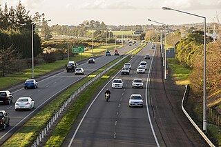
The Northwestern Motorway, part of State Highway 16, is the major western route and secondary northern route out of Auckland in New Zealand. Twenty-one kilometres in length, the motorway runs from Stanley St in Parnell through the Central Motorway Junction, and west through Central Auckland and West Auckland before continuing northwest and terminating outside of Kumeū at the Brigham Creek Roundabout. A large part of it forms the middle section of the Western Ring Route.

State Highway 20 (SH 20), also known as the Southwestern Motorway, is a New Zealand state highway linking State Highway 1 at Manukau with State Highway 16 in Point Chevalier, via Māngere and Onehunga. Along with its spurs, State Highway 20A and 20B, the state highway serves Auckland Airport, the country's largest, therefore making SH 20 a key arterial route connecting the airport to the wider Auckland region and most of the upper North Island. The route also forms the southern part of the Western Ring Route, a 48 kilometres (30 mi) motorway route bypassing central Auckland.

The Waterview Connection is a motorway section through west/central Auckland, New Zealand. It connects State Highway 20 in the south at Mt Roskill to State Highway 16 in the west at Point Chevalier, and is a part of the Western Ring Route.
Bike Auckland, formerly Cycle Action Auckland (CAA) is a pro-cycling advocacy group in Auckland, New Zealand. The predominantly volunteer group aims to improve infrastructure and conditions, as well as perceptions of cycling to encourage more "everyday people" to use bicycles, including for commuting and recreation.

The Second Harbour Crossing is the name given to the proposed second transport link across the Waitematā Harbour in Auckland, New Zealand. Planners have also referred to new links across the harbour as the Additional Waitematā Harbour Crossing (AWHC) or the Waitematā Harbour Connections.
The Christchurch Southern Motorway is the main southern route into and out of Christchurch, New Zealand. The motorway forms part of State Highway 1 and State Highway 76.

The Northwestern Cycleway, sometimes also referred to as the North West or Northwestern Cycle Route, is a 12 km mostly off-road cycle route in New Zealand that connects the Auckland CBD with the suburb of Westgate. For most of its length, it runs alongside the Northwestern Motorway.

The Waikaraka Cycleway is an off-road cycleway in the south of the Auckland isthmus, New Zealand, running from the suburb of Wesley along New Zealand State Highway 20 to Onehunga and then continuing along the shoreline of the Manukau Harbour beside mostly industrialised areas until it ends at Hugo Johnston Drive, in Southdown.

Cycling in Auckland is a mode of transport in Auckland, New Zealand. The dominance of the car in the city, the negative attitudes of car drivers and general changes in transport patterns have made it a very marginal transport mode in the early 21st century, with remaining cyclists often riding for leisure and sports purposes.

The Nelson Street Cycleway is a cycleway in Auckland, New Zealand. The most well-known section of the path is Te Ara I Whiti, translated as, and commonly known as Lightpath. The cycleway then continues on to the Nelson Street arterial road into the City Centre.


