Transport in Auckland

Last updated

Transport in Auckland, New Zealand's largest city, is defined by factors that include the shape of the Auckland isthmus (with its harbours [1] creating chokepoints and long distances for land transport), the suburban character of much of the urban area, a history (since World War II) of focusing investment on roading projects rather than public transport, [2] and high car-ownership rates.

Contents

These factors have contributed to a transport system that is highly dependent on private motor vehicles. Several motorways radiating to the north, northwest, southwest and south act as the backbone of the city's road network, with the busiest section of motorway carrying over 200,000 vehicles a day. [3] The use of public transport in Auckland was high until the 1950s but subsequently declined during the second half of the 20th century, [4] before experiencing a strong resurgence from the early 2000s. [5] With the motorway network now largely completed, [6] major efforts are underway to increase public transport use to address Auckland's congestion. [7] Recent efforts have also focused on making cycling a safer and more attractive transport option. [8] [9] [10]

Auckland has New Zealand's largest commercial port (mostly used for international commerce) and the country's largest international airport. It also has the Southern Hemisphere's largest marina.

History

Pre-European period

Throughout Auckland's pre-European period, its strategic location on the Waitematā and Manukau harbours had important transport implications. Māori hauled waka (canoes) between the harbours at portages, short traversable sections of land that connected the bodies of water. Some of the most major portages were Te Tō Waka, the shortest portage located at Ōtāhuhu, [11] Te Tōanga Waka (the Whau River portage), [12] [13] as well as Te Pai o Kaiwaka, the Waiuku portage which connected the Manukau Harbour to the Waikato River in the south, [14] and Te Tōangaroa in the north-west, connecting the Waitematā and Kaipara harbours overland at Kumeū. [15] [16]

19th and early 20th century

Lower Queen Street in 1919, with trams, cars and horse-drawn taxis visible. Queen Street Lower Auckland.jpg
Lower Queen Street in 1919, with trams, cars and horse-drawn taxis visible.

As a port city, Auckland's initial (19th century) urban growth occurred in an intense fashion, concentrated around the harbour in a similar manner to most other mercantile cities, with lack of transportation options limiting development to locations within walking distance of each other. The overcrowding of the inner city eventually created a demand for expansion made viable when new transportation technology appeared around 1900 in the form of streetcars (trams) and railways arriving in Auckland.

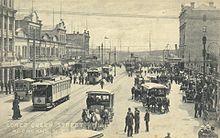
Auckland's first tram line, from the CBD to Ponsonby via Karangahape Road, opened on 24 November 1902. As the system grew, it facilitated the expansion of Auckland's built-up area in two ways: in an intermittent linear pattern to the west and south along the railway line, and in a more continuous manner along the main routes. The demand for more living space from people who had been confined to the crowded downtown area coupled with an affordable and reliable transport network led to the creation of many of Auckland's original suburbs, along Great North Road, New North Road, Sandringham Road, Dominion Road, Mt Eden Road, Manukau Road and Remuera Road, forming a new arc of suburban development by 1915.

Auckland first railway, to Onehunga, opened in 1873. [17] Expansion of the railway network facilitated growth in more distant locations such as Otahuhu and New Lynn, while ferries served Devonport, Takapuna and Birkenhead on the North Shore. Auckland's urban development in the early twentieth century is intrinsically linked to its transport networks, and because of their limited reach the city developed in a fairly compact manner to maximise the efficiency of the tram, railway and ferry systems. However, this situation was not to last for long, as even before the Second World War the car was becoming an integral part of life for many New Zealanders, opening up previously unreachable land for development.

Late 20th century

The number of cars in New Zealand skyrocketed from 69,521 in 1925 (when registration was first established) [18] to 194,217 in 1938. [19] This growing popularity meant that urban development could break free from the constraints of transport networks and occur anywhere roads were built. This led to a rapid decentralisation of urban growth, today often referred to as urban sprawl, in the 30 years after World War II. In an effort to compete with increasingly popular suburban shopping malls, parking lots and later parking buildings were built in the city centre. The first municipal parking building (Britomart Place) was completed in 1958. [20]

The tram system was dismantled in the 1950s [20] and subsequent efforts to improve the rail network were not implemented. [21] Meanwhile, a substantial motorway network was developed that facilitated urban growth to the north, northwest and south. These decisions led to Auckland becoming a highly car dependent city.

Auckland Airport moved to its current site near Māngere in 1966, having been previously located in Whenuapai.

21st century

Continued strong population growth, combined with cheaper car imports, led to growing traffic congestion across much of Auckland in the 1990s and early 2000s. [22]

In response to growing congestion, central and local government increased transport investment from around $500 million a year in 2000 to over $2 billion in 2015. [23] This increased investment largely completed Auckland's motorway network, funded the upgrade and electrification of the city's rail network, and supported construction of the Northern Busway.

Despite these improvements, rapid population growth means that transport is still a major challenge for Auckland, with congestion costing the city around $1.3 billion a year. [24] In 2009, Paul Mees, an Australian academic who had advocated for greater public transport adoption said Auckland had "the most unbalanced transport policies of just about [any city] in the world" alongside other academics who believed the city had underinvested in public transportation. [25] [26]

Road transport

Overview

Auckland's downtown has a number of parking buildings. Car Parking Building In Auckland CBD.jpg
Auckland's downtown has a number of parking buildings.

There are over 7,000 km of roads in the Auckland region [28] made up of motorways, arterial roads and local streets.

Motorway network

An extensive motorway network was planned for Auckland in the 1950s [30] and 1960s. [31] Auckland's first motorway was a 3.2 kilometre section of the Southern Motorway, between Penrose and Mt Wellington, that was opened in 1953. [32] By 2017 there was over 220 km of motorways in Auckland, carrying over 900,000 trips per day [33] on the following routes:

Because of Auckland's geography and road network layout, many motorways also have arterial road functions and are used for short-distance trips. Access to the motorway network is controlled through ramp signals, which regulate the flow of traffic onto the motorway. While this causes delays and vehicle queues when getting onto the motorway, it produces smoother through flows on the motorway itself. [34]

Major arterial roads

Around 16% of Auckland's overall road network is classified as either a primary or secondary arterial road. [35] These roads generally have a speed limit of 50 km/h in urban areas and serve a wide variety of functions, providing for the movement of people, goods and services as well as public transport services, cycleways, on-street parking and access to businesses and residences.

Major arterial roads
Northern Auckland Whangaparaoa Road, Hibiscus Coast Highway, Coatesville-Riverhead Highway, East Coast Road, Albany Highway, Dairy Flat Highway, Oteha Valley Road, Constellation Drive, Wairau Road, Glenfield Road, Onewa Road, Taharoto Road, Northcote Road, Lake Road
West Auckland Hobsonville Road, Brigham Creek Road, Don Buck Road, Lincoln Road, Te Atatu Road, Great North Road, Rata Street, Clark Street
Central Auckland New North Road, Carrington Road, Mt Albert Road, Dominion Road, Balmoral Road, St Lukes Road, Greenlane (East and West), Remuera Road, Manukau Road, Broadway, Great South Road, Ellerslie-Panmure Highway, Te Horeta Road, Neilson Street, Church Street
East Auckland Pakuranga Road, Ti Rakau Drive, Botany Road, Te Irirangi Drive
South Auckland Highbrook Drive, East Tamaki Road, Chapel Road, Great South Road, Harris Road, Mill Road, Redoubt Road, Mangere Road

To best balance their wide variety of different functions, at peak times some roads have bus or carpool lanes, [36] while on-street parking is frequently restricted.

Key infrastructure

Key bridges, tunnels and interchanges are critical to the functioning of Auckland's road network. Major pieces of infrastructure include:

Future projects

Providing new roading connections in Auckland, or widening existing corridors, is becoming increasingly difficult and expensive. [43] This means that most new roading projects are likely to be located in greenfield growth areas at the periphery of the Auckland urban area. Major roading projects currently planned or proposed include:

Public transport

An AT bus in Auckland Auckland Transport CRRC Electric Bus.JPG
An AT bus in Auckland
A train at Waitemata railway station EMU waits at Britomart.jpg
A train at Waitematā railway station

Public transport in Auckland consists of bus, ferry and commuter rail services. The hub of Auckland's public transport network is the Waitematā railway station near the Auckland waterfront, opened July 2003, where ferry, bus and train services meet.

Bus services

Bus services, the bulk of public transport in the city, are provided by privately owned bus companies contracted to Auckland Transport (AT) under the AT and AT Metro brands. The Northern Busway (opened in February 2008) provides bus rapid transit to Auckland's North Shore.

Frequent long-distance services, principally operated by Intercity and its subsidiary Newmans, link Auckland with all the main centres throughout the North Island.

Rail services

There are four suburban railway lines in Auckland – the Western, Southern, Eastern and Onehunga Lines. Urban rail services are operated by Auckland One Rail on behalf of AT under the AT brand. Since the early 2000s, there has been a substantial increase in services, with trains now operating every 10 minutes on the Western, Southern and Eastern lines at peak times.

Starting with the opening of Waitematā station in 2003, a series of investments has increased ridership to over 20 million annual boardings. These included double-tracking the Western Line, reopening the Onehunga Branch line, a programme of station upgrades and electrification of the entire Auckland suburban network between Swanson in the west and Papakura in the south. On 20 July 2015 the rollout of electric train services was completed. [45]

In 2015–16, work started on the City Rail Link project, which will improve network capacity and significantly reduce travel times between Western Line stations and the city centre. [46]

Auckland has only one long-distance passenger service: the Northern Explorer, operated by KiwiRail under the brand name The Great Journeys of New Zealand. A service operates three times per week in each direction between Auckland and Wellington.

Ferry services

Auckland Ferry Terminal, 2006 Auckland Ferry Terminal from Harbour.jpg
Auckland Ferry Terminal, 2006

A number of North Shore commuters who work in the Auckland CBD catch ferry services from Devonport, Stanley Bay, Bayswater, Beach Haven or Birkenhead. Services also connect the city with Waiheke Island, Gulf Harbour and Half Moon Bay. Ferries to Great Barrier Island are less regular, with services every 1–2 days, depending on the time of the year and the weather. Rangitoto, Motuihe Island and Tiritiri Matangi Island and the Coromandel have services usually focused on weekend and tourist trips.

Sea transport

Commercial shipping

The Ports of Auckland, located on the Waitematā Harbour in Auckland's city centre, is New Zealand's largest and busiest container port. [47] The 55 hectares of wharves and storage areas (mostly for containers, cars and other large shipments) are almost exclusively situated on reclaimed land, mostly in the former Commercial Bay, Official Bay and in Mechanics Bay. The main port facilities are:

In 2010 the Ports of Auckland contributed around $250 million per year to the Auckland economy. [48] A 2015 Port Future Study highlighted that in the longer-term future the port will either need to expand in its current location or move to a different location, most likely either in the Manukau Harbour or the Firth of Thames. [49]

Cruise ships

Auckland is an increasingly popular cruise ship port, with both Queens Wharf and Princes Wharf regularly being used as cruise ship terminals, especially during summer months. [50] Over 100 cruise ships annually visit Auckland. [51]

Air transport

With Auckland being the largest city of New Zealand, a great number of international and national flight connections exist. Main routes are to Australia, Singapore, Hong Kong, Japan, and to the US West Coast. Within New Zealand, the main connections are to the capital in Wellington and to the main city of the South Island, Christchurch. However, smaller planes fly to almost all other cities and to many small airports all over New Zealand.

Historically, Auckland had first been served by flying boat services from Mechanics Bay and Hobsonville. As aircraft such as the Short Solent and Short Sunderland were replaced by land-based planes, the first airport was opened at Māngere, supplanting earlier airfields at Ardmore and Whenuapai.

Auckland Airport Auckland Airport Carparks Main.jpg
Auckland Airport

Airports

Auckland Airport, New Zealand's largest airport, lies beside Manukau Harbour, in the southern suburb of Māngere. It is a major base for Air New Zealand. A new runway is planned north of the main airport area, with a shorter length well suitable for the booming intra-New Zealand flight market.

There were proposals in the 2000–2007 period to redevelop the airport at Whenuapai, an RNZAF airbase in Waitakere, to the northwest of the Auckland conurbation. The proposals became a political issue, partly resolved by the election of an anti-airport mayor in North Shore City, and finally resolved by the amalgamation of all Auckland councils into Auckland Council in 2010. The proposals had also been opposed by the government. [52]

Most private flights and light aircraft operate from the three smaller General Aviation (GA) airfields at the edges of the Auckland conurbation; Ardmore Airport south of the city which is NZ's busiest airfield in terms of movements, North Shore Aerodrome to the north and Parakai Airfield to the north west.

Mechanics Bay near the city centre, was the first international airport, and was used for many years as a base for flying boats of TEAL and amphibians of Tourist Air Travel and Sea Bee Air. The area now holds a heliport and the Auckland Marine Rescue Centre.

A Royal New Zealand Air Force facility at Hobsonville has been vacated and is currently under redevelopment primarily as a residential area, although some light commercial and industrial uses (for example super-yacht building) are present.

Walking and cycling

Typical example of pre-2015 on-street cycle lane. Mt Albert Road. Cycle Lanes On Mt Albert Road.jpg
Typical example of pre-2015 on-street cycle lane. Mt Albert Road.

Cycling

Increased funding for cycling from the New Zealand Government and Auckland Council in the mid-2010s led to the development of higher quality cycling infrastructure in Auckland, including the Grafton Gully cycleway, the Quay Street cycleway and Te Ara I Whiti (the Lightpath) between 2015 and 2017. Overall, 52 kilometres of new cycleways is planned to be delivered between 2015 and 2018. [53]

These improvements have already led to growth in the uptake of cycling. The northwest cycleway, which links with a number of projects delivered in recent years, saw its usage increase by 44% as a result of these improvements. [53] Auckland Transport (AT) and the New Zealand Transport Agency have developed a ten-year investment programme for cycling in Auckland that focuses on rolling out high quality cycling infrastructure to different parts of the city. [53] AT partners with community organisations to operate 10 'Bike Hubs' in the city to repair, refurbish and sell bikes as well as provide advice and information. [54]

Walking

All travel begins and ends with a walking trip, even though a relatively small proportion of "journeys to work" are made primarily by walking or jogging. At the 2013 census 4.5% of Aucklanders walked or jogged to work, up from 3.9% in 2001. [55]

Efforts are being made to improve the attractiveness of walking. A number of shared space projects were planned in several streets in the Auckland CBD. These upgrades aimed to improve the ability of pedestrians, cyclists and (slow-speed) motor vehicles to share the same transport spaces. [56] Elliott Street, Darby Street, Lorne Street, Fort Street, Jean Batten Place, and Fort Lane have been converted into shared spaces since 2011. [57] [58] The portion of Federal Street between Wellesley Street West and Victoria Street West has also been made into a shared space. [59] AT promotes 'Walking School Buses' to encourage children to walk to and from school in groups under adult supervision. [60]

See also

Related Research Articles

<span class="mw-page-title-main">South Auckland</span> Region of Auckland, New Zealand

South Auckland is one of the major geographical regions of Auckland, the largest city in New Zealand. The area is south of the Auckland isthmus, and on the eastern shores of the Manukau Harbour. The area has been populated by Tāmaki Māori since at least the 14th century, and has important archaeological sites, such as the Ōtuataua stonefield gardens at Ihumātao, and Māngere Mountain, a former pā site important to Waiohua tribes.

<span class="mw-page-title-main">Onehunga</span> Suburb in Auckland, New Zealand

Onehunga is a suburb of Auckland in New Zealand and the location of the Port of Onehunga, the city's small port on the Manukau Harbour. It is eight kilometres south of the city centre, close to the volcanic cone of Maungakiekie / One Tree Hill.

<span class="mw-page-title-main">Māngere</span> Suburb in Auckland, New Zealand

Māngere is a major suburb in South Auckland, New Zealand, located on mainly flat land on the northeastern shore of the Manukau Harbour, to the northwest of Manukau City Centre and 15 kilometres south of the Auckland city centre. It is the location of Auckland Airport, which lies close to the harbour's edge to the south of the suburb.

<span class="mw-page-title-main">Māngere Bridge (bridges)</span> Bridge in New Zealand

Māngere Bridge, officially also called the Manukau Harbour Crossing, is a dual motorway bridge over the Manukau Harbour in south-western Auckland, New Zealand, crossing between the suburb also known as Māngere Bridge and the suburb of Onehunga.

<span class="mw-page-title-main">Māngere Bridge (suburb)</span> Suburb of Auckland in New Zealand

Māngere Bridge is a suburb of Auckland, New Zealand, under the local governance of the Auckland Council. Surrounded by the Manukau Harbour, the area is the most north-western suburb of South Auckland, and is connected to Onehunga in central Auckland by three bridges that cross the Māngere Inlet. Many features of the Auckland volcanic field are found in and around Māngere Bridge, including Māngere Mountain, a 106-metre-high (348 ft) feature in the centre of the suburb, and Māngere Lagoon, a volcanic tidal lagoon opposite Puketutu Island in the harbour. The suburb is also home to Ambury Regional Park, a working farm and nature sanctuary run by Auckland Council, that connects to the Kiwi Esplanade and Watercare Coastal walkways.

<span class="mw-page-title-main">State Highway 1 (New Zealand)</span> Road in New Zealand

State Highway 1 is the longest and most significant road in the New Zealand road network, running the length of both main islands. It appears on road maps as SH 1 and on road signs as a white number 1 on a red shield, but it has the official designations SH 1N in the North Island, SH 1S in the South Island.

<span class="mw-page-title-main">Onehunga Branch</span> Branch line between Penrose and Onehunga in Auckland

The Onehunga Branch railway line is a section of the Onehunga Line in Auckland, New Zealand. It was constructed by the Auckland Provincial Government and opened from Penrose to Onehunga on 24 December 1873, and extended to Onehunga Wharf on 28 November 1878. It is 3.6 kilometres (2.2 mi) in length and is single-track only.

<span class="mw-page-title-main">Auckland isthmus</span> Narrow landstrip in Auckland, New Zealand

The Auckland isthmus, also known as the Tāmaki isthmus, is a narrow stretch of land on the North Island of New Zealand in the Auckland Region, and the location of the central suburbs of the city of Auckland, including the CBD. The isthmus is located between two rias : the Waitematā Harbour to the north, which opens to the Hauraki Gulf / Tīkapa Moana and Pacific Ocean, and the Manukau Harbour to the south, which opens to the Tasman Sea. The isthmus is the most southern section of the Northland Peninsula.

<span class="mw-page-title-main">Auckland Northern Motorway</span> Motorway located in Auckland, New Zealand

The Auckland Northern Motorway in the Auckland Region of New Zealand links Central Auckland and Warkworth in the former Rodney District via the Hibiscus Coast and North Shore. It is part of State Highway 1.

<span class="mw-page-title-main">Northwestern Motorway</span>

The Northwestern Motorway, part of State Highway 16, is the major western route and secondary northern route out of Auckland in New Zealand. Twenty-one kilometres in length, the motorway runs from Stanley St in Parnell through the Central Motorway Junction, and west through Central Auckland and West Auckland before continuing northwest and terminating outside of Kumeū. Its western terminus is at Brigham Creek Road in Whenuapai. A large part of it forms the middle section of the Western Ring Route.

<span class="mw-page-title-main">State Highway 20 (New Zealand)</span> Road in New Zealand

State Highway 20 (SH 20), also known as the Southwestern Motorway, is a New Zealand state highway linking State Highway 1 at Manukau with State Highway 16 in Point Chevalier, via Māngere and Onehunga. Along with its spurs, State Highway 20A and 20B, the state highway serves Auckland Airport, the country's largest, therefore making SH 20 a key arterial route connecting the airport to the wider Auckland region and most of the upper North Island. The route also forms the southern part of the Western Ring Route, a 48 kilometres (30 mi) motorway route bypassing central Auckland.

<span class="mw-page-title-main">Public transport in Auckland</span> Information about public transit in Auckland

Public transport in Auckland, the largest metropolitan area of New Zealand, consists of three modes: bus, train and ferry. Services are coordinated by Auckland Transport (AT) under the AT and AT Metro brands. Waitematā railway station is the main transport hub.

<span class="mw-page-title-main">Waterview Connection</span> Road in New Zealand

The Waterview Connection is a motorway section through west/central Auckland, New Zealand. It connects State Highway 20 in the south at Mt Roskill to State Highway 16 in the west at Point Chevalier, and is a part of the Western Ring Route.

<span class="mw-page-title-main">Second Harbour Crossing, Auckland</span>

The Second Harbour Crossing is the name given to the proposed second transport link across the Waitematā Harbour in Auckland, New Zealand. Planners have also referred to new links across the harbour as the Additional Waitematā Harbour Crossing (AWHC) or the Waitematā Harbour Connections.

<span class="mw-page-title-main">Auckland</span> Metropolitan city in the North Island of New Zealand

Auckland is a large metropolitan city in the North Island of New Zealand. It has an urban population of about 1,478,800. It is located in the greater Auckland Region, the area governed by Auckland Council, which includes outlying rural areas and the islands of the Hauraki Gulf, and which has a total population of 1,739,300 as of June 2023. It is the most populous city of New Zealand and the fifth largest city in Oceania. While Europeans continue to make up the plurality of Auckland's population, the city became multicultural and cosmopolitan in the late-20th century, with Asians accounting for 31% of the city's population in 2018. Auckland has the fourth largest foreign-born population in the world, with 39% of its residents born overseas. With its large population of Pasifika New Zealanders, the city is also home to the biggest ethnic Polynesian population in the world. The Māori-language name for Auckland is Tāmaki Makaurau, meaning "Tāmaki desired by many", in reference to the desirability of its natural resources and geography. Tāmaki means "omen".

The Western Ring Route is a motorway system being constructed in Auckland, New Zealand. It currently runs along the entire Southwestern Motorway, most of the Northwestern Motorway, the entire Upper Harbour Motorway, and the entire Upper Harbour Highway. When the Upper Harbour Highway is upgraded to motorway status, the route will surpass the Southern Motorway to become the longest motorway in New Zealand at 48 kilometres in length. It runs through Manukau, West Auckland, and the North Shore, bypassing the Auckland city centre and thus providing a second motorway route through the Auckland isthmus.

<span class="mw-page-title-main">Waikaraka Cycleway</span> Cycle route in Auckland, New Zealand

The Waikaraka Cycleway is an off-road cycleway in the south of the Auckland isthmus, New Zealand, running from the suburb of Wesley along New Zealand State Highway 20 to Onehunga and then continuing along the shoreline of the Manukau Harbour beside mostly industrialised areas until it ends at Hugo Johnston Drive, in Southdown.

<span class="mw-page-title-main">Auckland Airport Line</span>

The Auckland Airport Line was a proposed heavy rail line in Auckland, New Zealand, that would have linked Auckland Airport with the Auckland central business district via central isthmus suburbs.

<span class="mw-page-title-main">Waterview Tunnel</span> Road tunnel in Auckland, New Zealand

The Waterview Tunnel is a twin road tunnel in central Auckland, New Zealand. At 2,400 metres (7,900 ft) long, it is New Zealand's longest road tunnel. The tunnel, with three lanes of road vehicle traffic in each direction, connects State Highway 20 in the south at Mount Roskill to State Highway 16 in the west at Point Chevalier as part of the Waterview Connection. Its opening completed the Western Ring Route motorway system.

References

  1. Record number of roading projects on the go in Auckland in 2007/08 – Jackson, Bryan; Acting Chairman Transit New Zealand, article / public service announcement in The New Zealand Herald , Saturday 30 June 2007, Page C6
  2. Backtracking Auckland: Bureaucratic rationality and public preferences in transport planning Archived 13 April 2008 at the Wayback Machine – Mees, Paul; Dodson, Jago; Urban Research Program Issues Paper 5, Griffith University, April 2006
  3. Agency, NZ Transport. "State highway frequently asked questions | NZ Transport Agency". nzta.govt.nz. Retrieved 27 December 2017.
  4. Mode of Transport, Figure for New Zealand Regions Archived 27 September 2007 at the Wayback Machine (from the Travel Survey Highlights 1997–98, New Zealand Ministry of Transport)
  5. Rudman, Brian (1 April 2011). "Standing room only as Aucklanders embrace a transport revolution". The New Zealand Herald . Retrieved 11 July 2011.
  6. "Waterview Tunnel Opens, Motorway Network Completed – Greater Auckland". Greater Auckland. 3 July 2017. Retrieved 27 December 2017.
  7. Savage, Jared (29 July 2007). "Welcome to our traffic nightmare". The New Zealand Herald . Retrieved 24 November 2011.
  8. Orsman, Bernard (24 October 2008). "Big steps to change City of Cars". The New Zealand Herald . Retrieved 24 November 2011.
  9. Mees, Paul; Dodson, Jago (1 February 2001). "The American Heresy: Half a century of transport planning in Auckland". Presentation to joint conference of New Zealand Geographical Society / Australian Institute of Geographers conference, University of Otago, Dunedin. Urban Planning Program, Faculty of Architecture, Building & Planning, University of Melbourne. Retrieved 9 February 2011.
  10. Transport, Auckland. "Cycling & walking programme". Auckland Transport. Retrieved 27 December 2017.
  11. Furey, Louise (1986). "The Excavation of Westfield (R11/898), South Auckland". Records of the Auckland Institute and Museum . 23: 1–24. ISSN   0067-0464. JSTOR   42906356. Wikidata   Q58677261.
  12. Whau Local Board (August 2015). Whau Neighbourhood Greenways (PDF) (Report). Retrieved 21 July 2022.
  13. Paterson, Malcolm (2009). "Ko Ngā Kurī Purepure o Tāmaki, e Kore e Ngari i te Pō". In Macdonald, Finlay; Kerr, Ruth (eds.). West: The History of Waitakere. Random House. pp. 49–62. ISBN   9781869790080.
  14. Stone, R. C. J. (2001). From Tamaki-makau-rau to Auckland. Auckland University Press. ISBN   1869402596.
  15. Te Kawerau ā Maki; The Trustees of Te Kawerau Iwi Settlement Trust; The Crown (22 February 2014). "Te Kawerau ā Maki Deed of Settlement Schedule" (PDF). Retrieved 10 May 2022.
  16. Diamond, John T.; Hayward, Bruce W. (1979). The Māori history and legends of the Waitākere Ranges. The Lodestar Press. p. 10. ISBN   9781877431210.
  17. Auckland Transport. "Transport Timeline: key events in Auckland's transport history" (PDF).
  18. Pawson, Eric (15 December 2014). "Cars and the motor industry - A motorised society - Cars registered". Te Ara: The Encyclopedia of New Zealand .
  19. "Registration and Licensing of Motor-Vehicles". New Zealand Official Year Book. 1939.
  20. 1 2 History of Auckland City – Chapter 4 Archived 13 May 2008 at the Wayback Machine (from the Auckland City Council website. Accessed 7 June 2008.)
  21. "Rapid rail vs motorways". City Rail Link. Retrieved 27 December 2017.
  22. Taonga, New Zealand Ministry for Culture and Heritage Te Manatu. "Auckland congestion". teara.govt.nz. Retrieved 27 December 2017.
  23. Ministry of Transport (February 2016). "Auckland Transport Alignment Project – Foundation Report" (PDF).
  24. "Traffic congestion costs Auckland's economy $1.3b a year: Report". Stuff. Retrieved 27 December 2017.
  25. "Auckland one of most 'car-biased' cities in world". The New Zealand Herald . Retrieved 30 November 2020.
  26. "Solving Auckland's traffic mess". Stuff. 31 March 2009. Retrieved 30 November 2020.
  27. New Zealand Historical Atlas – McKinnon, Malcolm (Editor); David Bateman, 1997, Plate 75
  28. Transport, Auckland. "Asset Management Plans". Auckland Transport. Retrieved 27 December 2017.
  29. Transport, Auckland. "Traffic counts". Auckland Transport. Retrieved 27 December 2017.
  30. "The transport plan that changed Auckland – Greater Auckland". Greater Auckland. 1 August 2011. Retrieved 27 December 2017.
  31. "How Auckland missed the bus". The New Zealand Herald . 30 June 2000. ISSN   1170-0777 . Retrieved 27 December 2017.
  32. New Zealand Transport Agency (2008). Auckland motorways. ISBN   978-0-478-10554-4.
  33. "Auckland Motorways - Network Information". www.aucklandmotorways.com. Retrieved 27 December 2017.
  34. Dearnaley, Mathew (4 December 2006). "Motorway ramp lights turning on". The New Zealand Herald . Retrieved 24 November 2011.
  35. Ministry of Transport (September 2016). "Auckland Transport Alignment Project – Arterial Roads Report" (PDF).
  36. Transport, Auckland. "Bus & transit priority lanes". Auckland Transport. Retrieved 27 December 2017.
  37. "The Auckland Harbour Bridge Authority: 1951–1961" (PDF). 7 February 2007. Archived from the original (PDF) on 7 February 2007.
  38. Agency, NZ Transport. "SH18 Hobsonville Deviation and SH16 Brigham Creek Extension | NZ Transport Agency". www.nzta.govt.nz. Retrieved 27 December 2017.
  39. Dearnaley, Mathew (4 December 2006). "Spaghetti Junction comes to the boil". The New Zealand Herald . Retrieved 24 November 2011.
  40. Agency, NZ Transport. "SH1 Victoria Park Tunnel | NZ Transport Agency". nzta.govt.nz. Retrieved 27 December 2017.
  41. "Viaduct upgrade gets under way". Stuff.co.nz. 8 July 2009. Retrieved 25 April 2017.
  42. "Auckland's Waterview Tunnel open to traffic at last". Stuff.co.nz. 2 July 2017. Retrieved 2 July 2017.
  43. 1 2 Ministry of Transport (September 2016). "Auckland Transport Alignment Project – Recommended Strategic Approach" (PDF).
  44. "New Government bins Auckland's East-West link, after PM meets Mayor". Stuff.co.nz. 2 November 2017. Retrieved 2 November 2017.
  45. "Auckland's trains going all-electric". Auckland Transport. 13 July 2015. Retrieved 3 May 2017.
  46. "Rail tunnel Auckland's only option – report". 3 News NZ. 23 November 2012.
  47. "Cargo Handling". Ports of Auckland Ltd. Retrieved 29 December 2017.
  48. Market Economics (11 October 2011). "Economic Impacts of the Ports of Auckland" (PDF). Ports of Auckland Ltd.
  49. "Port Future Study | Port Future Study reports". www.portfuturestudy.co.nz. Retrieved 29 December 2017.
  50. Spectacular cruise ship season begins Archived 14 October 2008 at the Wayback Machine (from the Ports of Auckland website, 25 October 2006)
  51. "Contributing to New Zealand". Ports of Auckland Ltd. Retrieved 29 December 2017.
  52. "Government won't back Whenuapai airport proposal". The New Zealand Herald . 13 December 2004. Retrieved 17 July 2017.
  53. 1 2 3 Auckland Transport (1 August 2017). "Cycling Programme Business Case" (PDF).
  54. Transport, Auckland. "Bike Hubs". Auckland Transport. Retrieved 13 April 2024.
  55. "Journey to Work Patterns in the Auckland Region | Ministry of Transport". www.transport.govt.nz. Retrieved 27 December 2017.
  56. Orsman, Bernard (19 January 2010). "$43.4m bill to mix cars and pedestrians". The New Zealand Herald . Retrieved 15 March 2010.
  57. "Auckland's side streets too 'car-centric'". The New Zealand Herald – nzherald.co.nz. 17 January 2015. Retrieved 26 November 2017.
  58. "Council projects". Auckland Council. Retrieved 24 July 2016.
  59. "Auckland's side streets too 'car-centric'". Radio New Zealand. 17 January 2015. Retrieved 28 July 2017.
  60. Transport, Auckland. "Walking School Bus". Auckland Transport. Retrieved 13 April 2024.