The North Shore is one of the major geographical regions of Auckland, the largest city in New Zealand. The area is defined as the northern shores of the Waitematā Harbour as far north as the Ōkura River.
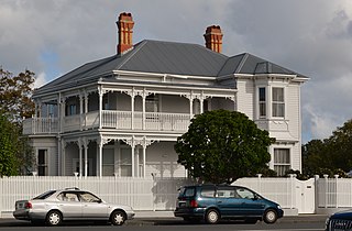
Herne Bay is a suburb of Auckland, New Zealand. It is located on the southwestern shore of the Waitematā Harbour to the west of the Auckland Harbour Bridge. It is known for its extensive harbour views, marine villas and Edwardian age homes. Herne Bay has been a prosperous area since the 1850s due to its outlook over the Waitemata Harbour. It ranked as the most expensive suburb in New Zealand in 2015. In 2021 it again topped rankings of the most expensive suburbs in New Zealand, with a median property value of $3.25 million.

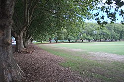
Freemans Bay is the name of a former bay and now inner city suburb of Auckland, in the North Island of New Zealand. The bay has been filled in to a considerable extent, with the reclamation area now totally concealing the ancient shoreline. Historically a poor and often disreputable quarter, it is now a comparatively wealthy and desirable neighbourhood known for its mix of heritage homes and more recent single-dwelling houses, as well as for its two large parks.

Grey Lynn is an inner suburb of Auckland, New Zealand, located 3 kilometres (1.9 mi) to the west of the city centre. Originally a separate borough, Grey Lynn amalgamated with Auckland City in 1914.

Ponsonby is an inner-city suburb of Auckland located 2 km west of the Auckland CBD. The suburb is oriented along a ridge running north–south, which is followed by the main street of the suburb, Ponsonby Road.
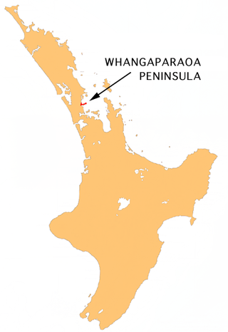
The Whangaparāoa Peninsula is a suburban area about 30–50 km north of Auckland, New Zealand. It had 39,140 residents in June 2024. It stretches from Red Beach, where it connects to Kingsway, Orewa and Silverdale, and extends to Army Bay in the Hauraki Gulf. It is part of the Hibiscus Coast. The area is populated by residents who work on the peninsula, or commute from the area to other parts of the Hibiscus Coast, the North Shore, Rodney district, Auckland CBD and beyond for work. They travel by vehicle, or via the Gulf Harbour ferry at Gulf Harbour Marina, or the Hibiscus Coast Bus Station at Silverdale. There is one main road along its entire length, which is accessible from State Highway 1 via Hibiscus Coast Highway at Silverdale, or from Hibiscus Coast Highway at Orewa via Red Beach. It is popular as a tourist destination for catching a ferry to Tiritiri Matangi Island, and for visiting Shakespear Regional Park. It has one open (Whangaparāoa Golf Club) and one closed golf club (Gulf Harbour Country Club), beaches, sporting and recreation facilities, a library, shops, businesses and public and private primary and secondary schools. The median age of the population is in the 30s-40s.

Hataitai is an inner-city suburb of Wellington, the capital of New Zealand, 3.5 kilometres southeast of the city centre. The suburb extends over the southeastern flank of Mount Victoria and down a valley between the Town Belt and a ridge along the shoreline of Evans Bay. Hataitai is bounded by Hepara Street, Grafton Road and the suburb of Roseneath in the north, Wellington Harbour in the east, Cobham Drive, Wellington Road and Crawford Road in the south, and Alexandra Road in the west.

Karangahape Road is one of the main streets in the central business district (CBD) of Auckland, New Zealand. The massive expansion of motorways through the nearby inner city area – and subsequent flight of residents and retail into the suburbs from the 1960s onwards – turned it from one of Auckland's premier shopping streets into a marginal area with the reputation of a red-light district. Now considered to be one of the cultural centres of Auckland, since the 1980s–1990s it has been undergoing a slow process of gentrification, and is now known for off-beat cafes and boutique shops.

Viaduct Harbour, formerly known as Viaduct Basin, is a former commercial harbour on the Auckland waterfront that has been turned into a development of mostly upscale apartments, office space and restaurants. It is located on the site of a formerly run-down area of the Freemans Bay / Auckland CBD waterfront in Auckland, New Zealand. As a centre of activity of the 2000 America's Cup hosted by the Royal New Zealand Yacht Squadron, as well as the 2022 Rally New Zealand, the precinct enjoyed considerable popularity with locals and foreign visitors.

Saint Marys Bay is an inner suburb of Auckland, New Zealand.

Kingsland is an inner-city suburb of Auckland, the largest and most populous urban area in New Zealand. Kingsland is under the local governance of the Auckland Council. It is the home of Eden Park, New Zealand's largest stadium, which hosted the finals for the 2011 Rugby World Cup. Kingsland has a village centre that contains a series of shops, restaurants, pubs and monthly markets.

Te Atatū Peninsula is a waterfront suburb of West Auckland surrounded by the Waitematā Harbour. The area was home to brickworks and farmland until the Northwestern Motorway was constructed in the 1950s, after which Te Atatū developed a low and medium-cost suburb. The area south of the motorway became known as Te Atatū South. The Auckland Harbour Board intended to develop a port on the peninsula for much of the 20th century. After plans for this were abandoned, the land was redeveloped into Footrot Flats Fun Park, an amusement park which operated in the 1980s. During the late 2010s, large-scale housing intensification led to the population of Te Atatū greatly expanding.

Massey is a northern suburb in West Auckland, New Zealand. It was formerly a northern suburb of Waitakere City, which existed from 1989 to 2010 before the city was amalgamated into Auckland Council. The suburb was named after former Prime Minister of New Zealand William Massey. Massey is a relatively large suburb and can be divided into three reasonably distinctive areas, Massey West, Massey East and Massey North. Parts of Massey East are also known as 'Royal Heights', which is home to the Royal Heights shopping centre.

The Wynyard Quarter is a reclaimed piece of land on the Waitematā Harbour at the western edge of the Auckland waterfront, New Zealand.

The Auckland Central Business District (CBD), or Auckland city centre, is the geographical and economic heart of the Auckland metropolitan area. It is the area in which Auckland was established in 1840, by William Hobson on land gifted by mana whenuahapū Ngāti Whātua Ōrākei. It is New Zealand's leading financial hub, and the centre of the country's economy; the GDP of the Auckland Region was NZD$139 billion in the year ending September 2023.

The Victoria Park Tunnel is a motorway tunnel completed in 2012 on New Zealand State Highway 1 in Auckland, New Zealand, taking northbound traffic off the Victoria Park Viaduct, which was converted to all southbound traffic. It lies mostly under Victoria Park.

Auckland is a large metropolitan city in the North Island of New Zealand. It has an urban population of about 1,531,400. It is located in the greater Auckland Region, the area governed by Auckland Council, which includes outlying rural areas and the islands of the Hauraki Gulf, and which has a total population of 1,798,300 as of June 2024. It is the most populous city of New Zealand and the fifth largest city in Oceania. While Europeans continue to make up the plurality of Auckland's population, the city became multicultural and cosmopolitan in the late-20th century, with Asians accounting for 34.9% of the city's population in 2023. Auckland has the fourth largest foreign-born population in the world, with 39% of its residents born overseas. With its sizable population of Pasifika New Zealanders, the city is also home to the largest ethnic Polynesian population in the world. The Māori-language name for Auckland is Tāmaki Makaurau, meaning "Tāmaki desired by many", in reference to the desirability of its natural resources and geography.

Matakana is a small town in the Rodney Ward of Auckland Council of New Zealand. Warkworth lies about 9 km to the south-west, Snells Beach the same distance to the south, Ōmaha is about 7 km to the east, and Leigh about 13 km to the north-east. The Matakana River flows through the town and into Kawau Bay to the south-east.
Windsor Park is a small suburb located on the North Shore of Auckland, which is in New Zealand.

Hobson Street is a major street in Auckland, New Zealand. It lies on the western side of Queen Street. It is a commercial and high-rise residential street, and provides access to the Auckland Northern Motorway going south, and the Northwest Motorway going west. For most of its length it is one-way. One block to the west is Nelson Street, which is one-way in the other direction and provides access to the central city for traffic exiting from the motorways. One block to the east is Albert Street, part of Mayoral Drive, and Vincent Street. The area encompassed by these streets is called Hobson Ridge by Statistics New Zealand.