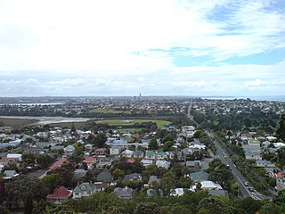
Devonport is a harbourside suburb of Auckland, New Zealand. It is located on the North Shore, at the southern end of the Devonport Peninsula that runs southeast from near Lake Pupuke in Takapuna, forming the northern side of the Waitematā Harbour. East of Devonport lies North Head, the northern promontory guarding the mouth of the harbour.
The North Shore is part of the large urban area of Auckland, New Zealand, located to the north of the Waitematā Harbour. To the east, has the Hauraki Gulf, to the west, is West Auckland, to the south, has the Waitematā Harbour and Central Auckland, to the north has the Hibiscus Coast. From 1989 until 2010, North Shore City was an independent city within the Auckland Region, until it was incorporated into the Auckland Council.

The Auckland Harbour Bridge is an eight-lane motorway bridge over the Waitematā Harbour in Auckland, New Zealand. It joins St Marys Bay on the Auckland city side with Northcote on the North Shore side. It is part of State Highway 1 and the Auckland Northern Motorway. The bridge is operated by the NZ Transport Agency (NZTA). It is the second-longest road bridge in New Zealand, and the longest in the North Island.

Queen Street is the major commercial thoroughfare in the Auckland CBD, Auckland, New Zealand's main population centre. The northern end is at Queens Wharf on the Auckland waterfront, adjacent to the Britomart Transport Centre and the Downtown Ferry Terminal. The road is close to straight, the southern end being almost three kilometres away in a south-southwesterly direction on the Karangahape Road ridge, close to the residential suburbs in the interior of the Auckland isthmus.

Auckland City was a territorial authority with city status covering the central isthmus of the urban area of Auckland, New Zealand. It was governed by the Auckland City Council from 1989 to 2010, and as a territory within the wider Auckland Region, was also governed by Auckland Regional Council. Auckland City was disestablished as a local authority on 1 November 2010, when Auckland City Council was amalgamated with other councils of the Auckland Region into the new Auckland Council. At the time of its disestablishment, the city had a resident population of around 450,000.

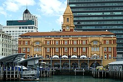
Waitematā railway station, commonly known as Britomart railway station or Britomart Transport Centre, is the public transport hub in the central business district of Auckland and the northern terminus of the North Island Main Trunk railway line. It combines a railway station in a former Edwardian post office, extended with expansive modernist architectural elements, with a bus interchange. It is at the foot of Queen Street, the main commercial thoroughfare of the CBD, with the main ferry terminal just across Quay Street.

Mechanics Bay is a reclaimed bay on the Waitematā Harbour in Auckland, New Zealand. It is also the name of the area of the former bay that is now mainly occupied by commercial and port facilities. Sometimes the bay formed between Tāmaki Drive and the western reclamation edge of Fergusson Container Terminal is also referred to as Mechanics Bay.

Waihorotiu, sometimes called the Waihorotiu Stream and the 'Queen Street River', is a stream that ran down the Queen Street gully in the Auckland CBD, New Zealand, into the Waitemata Harbour. It has long since been covered over and put underground by the urbanisation of the area.

Ports of Auckland Limited (POAL), the successor to the Auckland Harbour Board, is the Auckland Council-owned company administering Auckland's commercial freight and cruise ship harbour facilities. As the company operates all of the associated facilities in the Greater Auckland area, this article is about both the current company and the ports of Auckland themselves.

The Wynyard Quarter is a reclaimed piece of land on the Waitematā Harbour at the western edge of the Auckland waterfront, New Zealand.

The Auckland waterfront is a city-side stretch of the southern Waitematā Harbour coastline in Auckland, New Zealand. Previously mostly dominated by Ports of Auckland uses, from the 2000s on it is becoming increasingly open to recreational public use, with a number of former wharves being converted to office, entertainment, and later also some residential uses.

Public transport in Auckland, the largest metropolitan area of New Zealand, consists of three modes: bus, train and ferry. Services are coordinated by Auckland Transport under the AT Metro brand. Waitematā railway station is the main transport hub.

The Auckland Central Business District (CBD), or Auckland city centre, is the geographical and economic heart of the Auckland metropolitan area. It is the area in which Auckland was established in 1840, by William Hobson on land gifted by mana whenuahapū Ngāti Whātua Ōrākei. It is New Zealand's leading financial hub, and the centre of the country's economy; the GDP of the Auckland Region was $126.917 billion in the year ending March 2022.

Auckland Town Hall is an Edwardian building on Queen Street in the Auckland CBD, New Zealand, known both for its original and ongoing use for administrative functions, as well as its famed Great Hall and separate Concert Chamber. Auckland Town Hall and its surrounding context is highly protected as a 'Category A' heritage site in the Auckland District Plan.

The Sentinel is a luxury residential skyscraper in Takapuna, the central business area of North Shore City, New Zealand. The largest and currently only skyscraper in the city, it has 30 storeys. and is 120 m tall. It offers views over the Waitemata Harbour, the wider Hauraki Gulf as well as over to the Auckland CBD skyline. The Sentinel was opened to the first residents in February 2008.

The Second Harbour Crossing is the name given to the proposed second transport link across the Waitematā Harbour in Auckland, New Zealand. Planners have also referred to new links across the harbour as the Additional Waitematā Harbour Crossing (AWHC) or the Waitematā Harbour Connections.
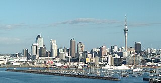
Auckland is a large metropolitan city in the North Island of New Zealand. Auckland is the most populous urban area in New Zealand and the fifth largest city in Oceania. It has an urban population of about 1,478,800. It is located in the greater Auckland Region, the area governed by Auckland Council, which includes outlying rural areas and the islands of the Hauraki Gulf, and which has a total population of 1,739,300. While Europeans continue to make up the plurality of Auckland's population, the city became multicultural and cosmopolitan in the late-20th century, with Asians accounting for 31% of the city's population in 2018. Auckland has the fourth largest foreign-born population in the world, with 39% of its residents born overseas. With its large population of Pasifika New Zealanders, the city is also home to the biggest ethnic Polynesian population in the world. The Māori-language name for Auckland is Tāmaki Makaurau, meaning "Tāmaki desired by many", in reference to the desirability of its natural resources and geography.
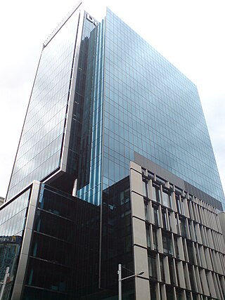
The Deloitte Centre is a skyscraper office tower located in Auckland, New Zealand. Built between 2006–2009, it contains 18 levels of offices as well as 4 basement car parks and 3 levels of plant, and a special two storey high architectural feature on the top giving a total height of 100 meters. The building will have 5 stars in the 'Green Star' environmental rating.

Quay Street is the northernmost street in the Auckland CBD, New Zealand. The Auckland Ferry Terminal, which has ferries running to Devonport, Waiheke Island, and other places in Waitematā Harbour; the Hilton Auckland hotel; and Ports of Auckland are on the north side of the street. The Britomart Transport Centre, Queen Elizabeth Square and Grand Mercure Auckland hotel are on the south side.