East Coast Bays

Last updated

East Coast Bays
East Coast Bays (1959) (cropped).jpg
View of the East Coast Bays south from Browns Bay in 1959
East Coast Bays
Coordinates: 36°43′52″S174°44′38″E / 36.731°S 174.744°E / -36.731; 174.744
Country New Zealand
Island North Island
Region Auckland Region

East Coast Bays is a string of small suburbs that form the northernmost part of the North Shore, part of the contiguous Auckland metropolitan area in New Zealand. The suburbs line the north-east coast of the city along the shore of the Hauraki Gulf and Rangitoto Channel. They include, from north to south, Long Bay, Torbay, Waiake Bay, Browns Bay, Rothesay Bay, Murrays Bay, Mairangi Bay, Campbells Bay and Castor Bay. Most of the East Coast Bays are covered under the East Coast Bays subdivision of the Hibiscus and Bays local board area.

Contents

Definition and etymology

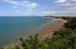
The East Coast Bays is a stretch of coastline in the North Shore of Auckland along the Hauraki Gulf, from Long Bay in the north to Castor Bay in the south. [1] Milford and Takapuna to the south are occasionally included in the definition. [2] The first uses of East Coast Bays from the 1870s referred to the eastern coast of the North Island. [3] [4] The first references to East Coast Bays as an area of the North Shore come from the latter 1920s. [5] [6] [7] [8]

Geography

Eroding Waitemata Group sandstone cliffs at Campbells Bay Campbells Bay cliffs 2014-01-18 14-53-24 NZ Auckland.jpg
Eroding Waitemata Group sandstone cliffs at Campbells Bay

The East Coast Bays area begins at the Ōkura River and Karepiro Bay in the north, [9] [10] starting from Long Bay Regional Park. [11] In the south, the mouth of the Wairau Creek forms the border between Castor Bay and Milford. [12]

The East Coast Bays are primarily formed from Waitemata Group sandstone, which accumulated on the sea floor during the early Miocene era, between 22 and 16 million years ago, and uplifted due to tectonic forces. [13] The sedimentary layers of the Waitemata sandstone can be clearly seen in the cliff faces along the bays. [14] Basement rocks in the area are greywacke and argillite, [14] and a number of the headlands of the East Coast Bays are formed from harder Parnell grit rocks, produced by lahars during the Miocene. [14]

Prior to human settlement, the inland East Coast Bays area was primarily a northern broadleaf podocarp forest, dominated by kauri, tōtara, mataī, miro, kauri and kahikatea trees. Pōhutukawa trees were a major feature of the coastline. [15] [16] By the 19th century, the area was primarily scrubland, vegetated by plants such as mānuka, tutu and harakeke flax. [17] [18] [19] An area of Torbay, the Awaruku Bush Reserve, is a remnant kahikatea forest, with the oldest trees in the reserve estimated to be over 650 years old. [20]

History

Māori history

Until the 1850s, Long Bay (Te Oneroa o Kahu) was one of the most densely settled areas of the North Shore by Tamaki Maori Looking south over Long Bay.jpg
Until the 1850s, Long Bay (Te Oneroa ō Kahu) was one of the most densely settled areas of the North Shore by Tāmaki Māori

Māori settlement of the Auckland Region began around the 13th or 14th centuries. [21] [22] The North Shore was settled by Tāmaki Māori, including people descended from the Tainui migratory canoe and ancestors of figures such as Taikehu and Peretū. [23] During his arrival in New Zealand, Hoturoa, captain of the Tainui, guided the waka to the Waiake Lagoon (Deep Creek), which was a safe anchorage for the canoe. [24]

Many of the early Tāmaki Māori people of the North Shore identified as Ngā Oho. [25] While the poor soils of the East Coast Bays area was a barrier to agriculture and settlement, Long Bay was one of the three most densely settled areas of the North Shore, [14] and the area features extensive archaeological sites. [26] Long Bay was a focal point for transport in the wider area, with many ara (overland paths) connecting Long Bay to Ōkura over the cliffs, and to Oteha and the Lukas Creek in Albany to the south-west. [23] [14]

Many of the headlands of East Coast Bays were sites for defensive , [13] including Te Toroa at Torbay, [24] [13] Ōmangaia between Waiake and Browns Bay, [27] and Rahopara at Castor Bay. [28] Outside of Long Bay, most areas of the East Coast Bays were utilised for seasonal resources. [14]

The warrior Maki migrated from the Kāwhia Harbour to his ancestral home in the Auckland Region, likely sometime in the 17th century. Maki conquered and unified many the Tāmaki Māori tribes as Te Kawerau ā Maki, including those of the North Shore. [29] [30]

After Maki's death, his sons settled different areas of his lands, creating new hapū. His sons Manuhiri and Maraeariki settled the North Shore and Hibiscus Coast. Maraeariki's daughter Kahu succeeded him, and she is both the namesake of the North Shore, Te Whenua Roa ō Kahu ("The Greater Lands of Kahu"), [31] [32] and the beach and bay of Long Bay, Te Oneroa ō Kahu ("The Long Beach of Kahu"). [22] Many of the iwi of the North Shore, including Ngāti Manuhiri, Ngāti Maraeariki, Ngāti Kahu, Ngāti Poataniwha, Ngāi Tai Ki Tāmaki and Ngāti Whātua, can trace their lineage to Kahu. [32] [27]

By the 18th century, the Marutūāhu iwi Ngāti Paoa had expanded their influence to include the islands of the Hauraki Gulf and the North Shore. [33] After periods of conflict, peace had been reached by the 1790s. [34] The earliest contact with Europeans began in the late 18th century, which caused many Tāmaki Māori to die of rewharewha, respiratory diseases. [35] During the early 1820s, most Māori of the North Shore fled for the Waikato or Northland due to the threat of war parties during the Musket Wars. Most people had returned by the 1830s, [26] [31] and remained at Te Oneroa until the 1850s. [36]

Early European settlement

Steamer ferry at Waiake Beach, ca 1910 Ferry steamer at Waiake Beach, Torbay, Auckland (21312806300) (cropped).jpg
Steamer ferry at Waiake Beach, ca 1910

The first Europeans to visit the area were timber merchants and kauri gum diggers in the 1830s, [26] and large gum digger camps were established at Murrays Bay and Campbells Bay. [16] In 1841, the Crown purchased the Mahurangi and Omaha blocks; an area that spanned from Takapuna to Te Ārai. The purchase involved some iwi with customary interests in the area, such as Ngāti Paoa, other Marutūāhu iwi and Ngāi Tai ki Tāmaki, but not others, such as Te Kawerau ā Maki or Ngāti Rango. [37] [38] [27] [39] The Crown spent until 1873 rectifying this sale, by making further deals with stakeholders. [38] [39]

The first permanent settlers arrived in East Coast Bays in the 1850s. [26] [40] [41] John Logan Campbell purchased the majority of the East Coast Bays in 1864 (Allotment 189, area spanning from Ōkura to Browns Bay), believing that there was coal in the area. [17] [42] The East Coast Bays were seen as an unproductive area for agriculture, and Campbell sold the land, with much of the area becoming dairy farms. [40] Major figures in the latter 19th century include the Vaughan family, who ran a sheep and cattle farm for over 100 years at Long Bay, [26] [43] Captain Charles Cholmondeley-Smith, whose established a sawmill, flaxmill and vineyard at Torbay, [44] [45] Peter Brown at Browns Bay, [46] and English settler Thomas Murray, who farmed Murrays and Mairangi bays. [19] [47]

The East Coast Bays became popular vacation destinations in the 1910s and 1920s. [14] Visitors primarily arrived by steam ships, [48] and the southern East Coast Bays area began to develop after the Milford to Bayswater tram improved access. Until the 1930s, the majority of houses constructed in the bays were holiday baches. [49] [14]

During World War II, the coast from Torbay south was fortified with defenses, including pillboxes along the coastline and hills, and barbed wire ditches. [13] [14] The largest fortification in East Coast Bays was the Castor Bay Battery and Camp, [28] which was disguised as a state housing project. [50]

Independent borough and city

The East Coast Bays City Council buildings in 1989 East Coast Bays City Council (1989).jpg
The East Coast Bays City Council buildings in 1989

After the end of World War II, local residents lobbied for the creation of an East Coast Bays borough, separate from Waitemata County. [51] The borough was established in April 1954 with approximately 7,000 residents, [52] and included the area between Torbay to Campbells Bay, excluding Long Bay and Castor Bay. The borough council immediately began working on roading projects to better connect the bays to Auckland, [52] and worked to improve water mains, sewerage, drainage, refuse collection and created a library service. [53] Browns Bay became the administrative and commercial centre of the East Coast Bays Borough, and smaller shopping centres grew in Mairangi Bay and Torbay. [46] [53] In 1959, the Auckland Harbour Bridge was constructed, which led to massive growth in the area, [53] with the area transitioning away from isolated holiday communities and becoming commuter suburbs for Auckland. [54] [46] By 1966, the population had doubled to 12,000 people, increasing to 16,000 by 1971. [53] Between 1971 an 1975, East Coast Bays was the fastest growing area of Auckland, seeing a population increase of 47.3%. This led to the opening of additional facilities such as Long Bay College, [55] and in 1975, the East Coast Bays had grown in size enough that the borough became a city. [53] [46] Over 3,000 dwellings were constructed between 1976 and 1986. [53]

Long Bay Regional Park was opened by the Auckland Regional Council in the early 1970s, becoming one of the first regional parks in Auckland. [56] In 1973, community groups including the Taiorahi Wilderness Committee and Deep Creek Valley Bush Society were established, to oppose the development of suburban housing in native bush areas. [55]

By 1986 the population had reached 31,000. [53] The city was merged into the wider North Shore City in 1989. [46]

Further development

Long Bay began to develop housing in the 1990s, due to zoning law changes. [57] In the early 1990s, Browns Bay Mall was opened. [46]

Education

The first school in the East Coast Bays was Browns Bay School, which was established in 1888. [58] This was followed by Campbells Bay Primary School, which opened in August 1925. [59] Population growth in the East Coast Bays area led to the construction of new schools, [60] including Torbay Primary School, [61] Murrays Bay Primary and Intermediate schools, [59] and Rangitoto College. [62] Rangitoto College has grown to become the largest secondary school in New Zealand. [63]

St John's School was the first Catholic school established in the East Coast Bays area, and was established in Mairangi Bay in 1961. [64] The secular Mairangi Bay School followed soon after in 1967. [65] Long Bay College is a secondary school that opened in 1975. [66] Three further primary schools were established in the 1970s: Glamorgan School in Torbay in 1972, Sherwood School in Browns Bay (1976) and Long Bay Primary School (1979). [67]

In 1973, Kristin School was established at the former Methodist Health Camp in Campbells Bay. [68] As the school grew rapidly, a new campus was opened in Albany in 1978. [69] The Corelli International Academic School of the Arts was a private composite (years 1–13) school which ran specialist programs in visual arts, music, drama and dance as well as the general curriculum. It opened in 2001, [14] and went into receivership in 2016. [70]

Politics

From 1876 until 1954, the area was administered by the Waitemata County, a large rural county north and west of the city of Auckland. [71] In 1954, most of the area split from the county, forming the East Coast Bays Borough, [71] and Castor Bay became a part of the Borough of Takapuna [72] (Takapuna City from 1961). [50] For the next twenty years, Long Bay remained a part of the Waitemata County. In 1974 the county was dissolved, [73] and Long Bay became a rural area incorporated into Takapuna City. [74]

In 1975, the population of the East Coast Bays had increased enough that it became the East Coast Bays City. [46] In 1989, East Coast Bays City, Takapuna City and the surrounding areas were amalgamated to form North Shore City. [46] North Shore City was amalgamated into Auckland Council in November 2010. [75]

Within the Auckland Council, the majority of East Coast Bays is a part of the Hibiscus and Bays local government area governed by the Hibiscus and Bays Local Board. It is a part of the Albany ward, which elects two councillors to the Auckland Council. This area is defined as the East Coast Bays subdivision of the Hibiscus and Bays local board area by Auckland Council. [76] The southernmost of the bays, Castor Bay, is a part of the Devonport-Takapuna local government area governed by the Devonport-Takapuna Local Board. It is a part of the North Shore ward, which elects two councillors to the Auckland Council.

East Coast Bays is also the name of an electorate from which an MP is elected to serve in the New Zealand Parliament, which first formed in 1972. Its current MP is Erica Stanford. [77]

Mayors of East Coast Bays

Five people served as mayor of the East Coast Bays Borough Council, and two serves as mayor of East Coast Bays City Council. [52] [55] [78]

Mayors of East Coast Bays Borough

  • 1954-1956: Reginald Henry Greville
  • 1956-1959: Claude Kendall
  • 1959-1962: Reginald Henry Greville
  • 1962-1968: Walter Stredwick
  • 1968-1974: Noel Liam Bradford
  • 1974-1975: Alan Morton McCulloch

Mayors of East Coast Bays City

  • 1975-1983: Alan Morton McCulloch
  • 1983-1989: Joseph John (Jack) Hinton

Related Research Articles

<span class="mw-page-title-main">North Shore, New Zealand</span> Subregion of Auckland, New Zealand

The North Shore is one of the major geographical regions of Auckland, the largest city in New Zealand. The area is defined as the northern shores of the Waitematā Harbour as far north as the Ōkura River.

<span class="mw-page-title-main">Northcote, Auckland</span> Suburb in Auckland, New Zealand

Northcote is a suburb of Auckland in northern New Zealand. It is situated on the North Shore, on the northern shores of Waitematā Harbour, 4 kilometres (2.5 mi) northwest of the Auckland City Centre. The suburb includes the peninsula of Northcote Point where the northern approaches to the Auckland Harbour Bridge are located, and Northcote Central, the commercial centre of Northcote. Northcote features two volcanic maars.

<span class="mw-page-title-main">Rangitoto Channel</span>

The Rangitoto Channel is an area of the Hauraki Gulf in the Auckland Region of New Zealand's North Island. The channel is north-east of the Waitematā Harbour, and is located between the North Shore and Rangitoto Island. The channel's traditional Ngāi Tai name is Te Awanui o Peretū, and is an important deep water shipping channel to reach the Ports of Auckland.

<span class="mw-page-title-main">Takapuna</span> Suburb in Auckland, New Zealand

Takapuna is a suburb located on the North Shore of Auckland, New Zealand. The suburb is an isthmus between Shoal Bay, arm of the Waitematā Harbour, and the Hauraki Gulf. Lake Pupuke, a volcanic maar and one of the oldest features of the Auckland volcanic field, is a freshwater lake located in the suburb.

<span class="mw-page-title-main">Glenfield, New Zealand</span> Suburb in Auckland, New Zealand

Glenfield is a suburb of Auckland, New Zelaand, located on the North Shore. Established as a rural community in the 1850s, the area developed as a suburban part of Auckland after the completion of the Auckland Harbour Bridge in 1959.

<span class="mw-page-title-main">Milford, New Zealand</span> Suburb in Auckland, New Zealand

Milford is a suburb located on the North Shore, Auckland. It is located on northern side of Lake Pupuke. It also has a popular swimming beach, which runs some two kilometres from Black Rock in the south to Castor Bay in the north. The Wairau Creek reaches the sea at the Hauraki Gulf at the northern end of Milford Beach, and its lower tidal reaches host the Milford Marina.

<span class="mw-page-title-main">Browns Bay, New Zealand</span> Suburb in Auckland, New Zealand

Browns Bay is one of the most northernmost suburbs in the contiguous Auckland metropolitan area, located in the North Shore. Named after the Brown family who settled here in 1876, Browns Bay became a holiday destination in the late 19th century. The area gradually developed into a suburb of Auckland in the 1950s, and was the administrative centre for the East Coast Bays City from 1975 until it was disestablished in 1989. During the 1990s, the suburb became a hub for the South African New Zealander community.

<span class="mw-page-title-main">Mairangi Bay</span> Suburb in Auckland, New Zealand

Mairangi Bay is a coastal suburb of North Shore, Auckland, located in the northern North Island of New Zealand, on the south-east-facing peninsula forming the northern side of the Waitematā Harbour. Mairangi Bay came under the local governance of the North Shore City Council until subsumed into the Auckland Council in 2010.

<span class="mw-page-title-main">Greenhithe, New Zealand</span> Suburb in Auckland, New Zealand

Greenhithe is a northwestern suburb of Auckland, New Zealand, located on the North Shore. Greenhithe was the location of Tauhinu, a fortified Te Kawerau ā Maki and Ngāti Whātua pā which overlooked the entrance to Oruamo or Hellyers Creek, that was settled until the 1820s. In the 1860s, the Forgham family established a community at Greenhithe, which by the 1880s had become a major fruit producer for Auckland. Boat repair and construction became major industries in Greenhithe in the 1960s.

<span class="mw-page-title-main">Torbay, New Zealand</span> Suburb in Auckland, New Zealand

Torbay is a northern suburb of Auckland, New Zealand. It is located in the upper East Coast Bays of the city's North Shore, and is governed by Auckland Council.

<span class="mw-page-title-main">Chatswood, New Zealand</span> Suburb in Auckland, New Zealand

Chatswood is a suburb in the city of Auckland, New Zealand, in the middle-eastern side of North Shore. It contains a primary school and many parks. To the south of Chatswood is Kendall's Bay, a small bay of the Waitematā Harbour. The suburb is under the governance of Auckland Council. The Royal New Zealand Navy's Kauri Point Armament Depot is located in Chatswood. Chelsea Sugar Refinery is located in Chatswood.

<span class="mw-page-title-main">Belmont, Auckland</span> Suburb in Auckland, New Zealand

Belmont is a suburb of Auckland, New Zealand, located on the North Shore. The suburb is in the North Shore ward, one of the thirteen administrative divisions of Auckland Council.

<span class="mw-page-title-main">Castor Bay</span> Suburb in Auckland, New Zealand

Castor Bay is a bay and suburb of the North Shore, located in Auckland which is in the North Island of New Zealand. Located between Milford and Campbells Bay, it is part of the East Coast Bays. To the east lies the islands of Rangitoto and Motutapu, which are easily visible from land. The suburb is in the North Shore ward, one of the thirteen administrative divisions of Auckland Council.

<span class="mw-page-title-main">Rothesay Bay</span> Suburb in Auckland, New Zealand

Rothesay Bay is a small suburb in Auckland's East Coast Bays region. The suburb is roughly the same size as Murrays Bay, the suburb to the immediate south.

<span class="mw-page-title-main">Murrays Bay</span> Suburb in Auckland, New Zealand

Murrays Bay is a small suburb in the East Coast Bays region, located in the North Shore of Auckland. The suburb is roughly the same size as Rothesay Bay, the suburb to the immediate north. It is primarily a residential area but does have a community centre, restaurant and café. Murrays Bay is regularly serviced by buses which go to Takapuna and the Auckland city centre.

<span class="mw-page-title-main">Long Bay, New Zealand</span> Suburb in Auckland, New Zealand

Long Bay is one of the northernmost suburbs of the North Shore, part of the contiguous Auckland metropolitan area located in New Zealand.

<span class="mw-page-title-main">Campbells Bay</span> Suburb in Auckland, New Zealand

Campbells Bay is a suburb of the North Shore located in Auckland, New Zealand. Centennial Park is a popular recreational space that has walking tracks and stunning harbour views.

<span class="mw-page-title-main">Waiake</span> Suburb in Auckland, New Zealand

Waiake is one of the northernmost suburbs of the North Shore, in Auckland, New Zealand. It is located in the East Coast Bays between the suburbs of Browns Bay to the south and Torbay to the north. It has a beach, which looks out to the Tor, a presque-isle at the north end of the beach that becomes an island at high tide. Waiake is under the local governance of the Auckland Council.

<span class="mw-page-title-main">Schnapper Rock</span> Suburb in Auckland, New Zealand

Schnapper Rock is a western suburb on the North Shore of Auckland, New Zealand. The suburb is currently under local governance of Auckland Council. The area was known for a gum digging hut used by early European settlers in the mid-19th century. North Shore Memorial Park was opened area in 1974, and the area developed into suburban housing in the early 2000s.

<span class="mw-page-title-main">Oruamo or Hellyers Creek</span> River in Auckland Region, New Zealand

Oruamo or Hellyers Creek is a stream and tidal estuary of Upper Waitematā Harbour in the Auckland Region of New Zealand's North Island. It flows through the western North Shore.

References

  1. "East Coast Bays". The New Zealand Herald . 21 June 2002. Retrieved 13 July 2023.
  2. McClure, Margaret (6 December 2007). "Auckland places - The North Shore". Te Ara - the Encyclopedia of New Zealand . Retrieved 13 July 2023.
  3. "Interprovincial". Bruce Herald. Vol. XI, no. 1032. 2 August 1878. p. 6 via Papers Past.
  4. "Shipping". Daily Telegraph. No. 7748. 1 May 1896. p. 2 via Papers Past.
  5. "Page 5 Advertisements Column 4". Auckland Star. Vol. LVII, no. 43. 20 February 1926. p. 5 via Papers Past.
  6. "North Shore Interests". The New Zealand Herald . Vol. LXIV, no. 19786. 5 November 1927. p. 14 via Papers Past.
  7. "No More "Brawls"". Auckland Sun. Vol. I, no. 257. 20 January 1928. p. 1 via Papers Past.
  8. "North Shore Progress". The New Zealand Herald . Vol. LXV, no. 19868. 11 February 1928. p. 12 via Papers Past.
  9. "Ōkura River". New Zealand Gazetteer. Land Information New Zealand. Retrieved 28 November 2023.
  10. "Karepiro Bay". New Zealand Gazetteer. Land Information New Zealand. Retrieved 13 July 2023.
  11. "Long Bay Regional Park". Auckland Council . Retrieved 13 July 2023.
  12. "Wairau Creek". New Zealand Gazetteer. Land Information New Zealand. Retrieved 13 July 2023.
  13. 1 2 3 4 Lutz, Heike; Chan, Theresa (2011). North Shore heritage – North Shore area studies and scheduled items list: volume 2 parts 6+ (PDF). Heritage Consultancy Services (Report). Auckland Council . Retrieved 7 July 2023.
  14. 1 2 3 4 5 6 7 8 9 10 Heritage Consultancy Services (1 July 2011). North Shore Heritage - Thematic Review Report Volume 1 (PDF) (Report). Auckland Council. ISBN   978-1-927169-21-6 . Retrieved 29 June 2023.
  15. Veart, Dave (2018). The Māori Archaeology of Te Raki Paewhenua/North Shore (Report). Auckland North Community and Development. p. 10. ISBN   978-0-9941358-4-1.
  16. 1 2 Willis 2018, pp. 2.
  17. 1 2 Cass 1989, pp. 5–6.
  18. Sheehan 2019, pp. 6.
  19. 1 2 Willis 2018, pp. 20–21.
  20. Janssen, Peter (January 2021). Greater Auckland Walks. New Holland Publishers. p. 40-41. ISBN   978-1-86966-516-6. Wikidata   Q118136068.
  21. Pishief, Elizabeth; Shirley, Brendan (August 2015). "Waikōwhai Coast Heritage Study" (PDF). Auckland Council . Retrieved 14 February 2023.
  22. 1 2 Ngāi Tai ki Tāmaki (April 2016). Cultural Values Assessment Report to New Zealand Transport Agency for Northern Corridor Improvements Project (NCI) (PDF) (Report). NZ Transport Agency . Retrieved 30 June 2023.
  23. 1 2 Willis 2018, pp. 6.
  24. Mossman, Sarah (August 2018). Cultural Values Assessment for America's Cup 36 - Wynyard and Hobson Planning Application (PDF). Te Kawerau Iwi Tribunal Authority (Report). Retrieved 30 June 2023.
  25. 1 2 3 4 5 Trilford, Danielle; Campbell, Matthew (30 July 2018). Long Bay Regional Park Northern Entrance, archaeological investigations (HNZPTA authority 2016/575) (PDF) (Report). CFG Heritage Ltd. Retrieved 12 July 2023.
  26. 1 2 3 Ngāi Tai Ki Tāmaki and the Trustees of the Ngāi Tai Ki Tāmaki Trust and the Crown (7 November 2015). "Deed of settlement schedule documents" (PDF). NZ Government. Archived (PDF) from the original on 13 February 2020. Retrieved 31 October 2021.
  27. 1 2 Cameron, Ewen; Hayward, Bruce; Murdoch, Graeme (2008). A Field Guide to Auckland: Exploring the Region's Natural and Historical Heritage (rev. ed.). Random House New Zealand. p. 137. ISBN   978-1-86962-1513.
  28. "Waitākere Ranges Heritage Area" (PDF). Auckland Council. December 2018. Retrieved 28 June 2021.
  29. Murdoch, Graeme (1990). "Nga Tohu o Waitakere: the Maori Place Names of the Waitakere River Valley and its Environs; their Background History and an Explanation of their Meaning". In Northcote-Bade, James (ed.). West Auckland Remembers, Volume 1. West Auckland Historical Society. p. 13-14. ISBN   0-473-00983-8.
  30. 1 2 Ngāti Manuhiri; The Crown (21 May 2011). "Deed of Settlement of Historical Claims" (PDF). New Zealand Government . Retrieved 18 May 2022.
  31. 1 2 Whaanga, Mel (March 2022). "He taonga o te rohe". Restore Hibiscus & Bays. Retrieved 30 June 2023.
  32. New Zealand Government; Ngāti Paoa (20 March 2021). "Ngāti Pāoa and the Trustees of the Ngāti Pāoa Iwi Trust and The Crown Deed of Settlement of Historical Claims" (PDF). New Zealand Government . Retrieved 1 September 2021.
  33. "Wenderholm Regional Park: Our History" (PDF). Auckland Council. 2015. Retrieved 4 May 2023.
  34. McKenzie, Fiona (May 2017). "Cultural Values Assessment for the Warkworth North Structure Plan and Associated Development" (PDF). Manuhiri Kaitiaki Charitable Trust. Auckland Council . Retrieved 4 July 2023.
  35. Ewen Cameron, Bruce Hayward and Graeme Murdoch (1997). A Field Guide to Auckland: Exploring the Region's Natural and Historic Heritage. p. 132. ISBN   1-86962-014-3.
  36. Rigby, Barry (August 1998). The Crown, Maori and Mahurangi 1840-1881 (PDF) (Report). Waitangi Tribunal . Retrieved 4 July 2023.
  37. 1 2 Stone 2001, pp. 188.
  38. 1 2 Te Kawerau ā Maki; The Trustees of Te Kawerau Iwi Settlement Trust; The Crown (22 February 2014). "Deed of Settlement of Historical Claim" (PDF). Retrieved 4 July 2023.
  39. 1 2 Willis 2018, pp. 25.
  40. Sheehan 2019, pp. 8.
  41. Willis 2018, pp. 13.
  42. Verran, David 2010, pp. 36.
  43. Willis 2018, pp. 7–8.
  44. Cass 1989, pp. 3–4.
  45. 1 2 3 4 5 6 7 8 Mace, Tania (October 2006). "Browns Bay Heritage Walk" (PDF). North Shore City Council . Retrieved 4 July 2023.
  46. Verran, David (20 April 2010). "Our history, East Coast Bays (Part one)". Auckland Libraries Heritage Collections. Retrieved 5 January 2023.
  47. Willis 2018, pp. 20–21, 30–31.
  48. Willis 2018, pp. 3.
  49. 1 2 Heritage Consultancy Services (1 July 2011). North Shore Heritage, Volume 2: North Shore Area Studied & Scheduled Items List (PDF) (Report). Auckland Council. ISBN   978-1-927169-23-0 . Retrieved 13 July 2023.
  50. Verran, David 2010, pp. 125.
  51. 1 2 3 Verran, David 2010, pp. 129.
  52. 1 2 3 4 5 6 7 Cass 1989, pp. 13.
  53. Gray & Sturm 2008, pp. 119.
  54. 1 2 3 Verran, David (October 2013). "The East Coast Bays from the 1960s to the 1980s". Channel Magazine. No. 37. p. 60. Retrieved 6 October 2022.
  55. Regional Parks Management Plan: Volume 1: Management Policies (PDF) (Report). Auckland Regional Council. August 2010. Retrieved 4 July 2023.
  56. He hītori mō te hanga ā-tāone o Tāmaki Makaurau: A brief history of Auckland's urban form (PDF) (Report). Auckland Council. December 2019. Retrieved 5 May 2023.
  57. "Browns Bay School" . Retrieved 11 January 2009.
  58. 1 2 Verran, David 2010, pp. 84.
  59. Verran, David 2010, pp. 83–84.
  60. "Welcome to Torbay School". Archived from the original on 2 March 2008. Retrieved 7 April 2009.
  61. "50th Jubilee 2006". Rangitoto College. Retrieved 25 April 2009.
  62. "Rangitoto College". Education Review Office. Retrieved 26 December 2021. Rangitoto College is New Zealand's largest, co-educational school.
  63. "A History of Development". St John's School. Archived from the original on 14 October 2008. Retrieved 24 January 2009.
  64. "Mairangi Bay Case Study 2" (PDF). Edtech Limited. Archived from the original (PDF) on 14 October 2008. Retrieved 24 January 2009.
  65. "Jubilees & reunions - Long Bay College". Education Gazette New Zealand. 78 (5). 29 March 1999.
  66. "Torbay History". Torbay School. Retrieved 13 July 2023.
  67. Verran, David 2010, pp. 85.
  68. "Our Story". Kristin School. Retrieved 19 December 2021.
  69. Dougan, Patrice (22 April 2016). "Prestigious school in receivership". New Zealand Herald.
  70. 1 2 Reidy, Jade (2009). "How the West Was Run". In Macdonald, Finlay; Kerr, Ruth (eds.). West: The History of Waitakere. Random House. pp. 238–239. ISBN   9781869790080.
  71. Verran, David 2010, pp. 253.
  72. Adam, Jack; Burgess, Vivien; Ellis, Dawn (2004). Rugged Determination: Historical Window on Swanson 1854-2004. Swanson Residents and Ratepayers Association Inc. pp. 38–39. ISBN   0-476-00544-2.
  73. Thematic Heritage Overview: AGRICULTURE/horticulture/undeveloped land/public open space 1960 - PRESENT (PDF) (Report). Auckland Council. July 2011. Retrieved 12 July 2023.
  74. Blakeley, Roger (2015). "The planning framework for Auckland 'super city': an insider's view". Policy Quarterly. 11 (4). doi: 10.26686/pq.v11i4.4572 . ISSN   2324-1101.
  75. "Council profile". aucklandcouncil.govt.nz. Auckland Council . Retrieved 9 January 2024.
  76. "Stanford, Erica - New Zealand Parliament". www.parliament.nz. Retrieved 22 November 2021.
  77. "Timeline of Auckland Mayors: An Online Exhibition". Auckland Council. 2016. Archived from the original on 10 January 2022. Retrieved 16 July 2023.

Bibliography