Rothesay Bay

Last updated

Rothesay Bay
Rothesay Bay - Auckland.jpg
The beach at Rothesay Bay at low tide, with the Hauraki Gulf and Rangitoto in the distance
Rothesay Bay
Coordinates: 36°43′16″S174°45′04″E / 36.721°S 174.751°E / -36.721; 174.751
CountryNew Zealand
City Auckland
Local authority Auckland Council
Electoral ward Albany ward
Local board Hibiscus and Bays Local Board
Area
[1]
  Land86 ha (213 acres)
Population
 (June 2024) [2]
  Total
3,060
Postcode(s)
0630
Northcross Browns Bay
Oteha
Pfeil oben.svg
Pfeil links.svgRothesay BayPfeil rechts.svg
Pfeil unten.svg
(Hauraki Gulf)
Pinehill Murrays Bay

Rothesay Bay is a small suburb in Auckland's East Coast Bays region. The suburb is roughly the same size as Murrays Bay, the suburb to the immediate south.

Contents

Geography

Rothesay Bay beach in 1963 Rothesay Bay beach looking north, East Coast Bays, 1963.jpg
Rothesay Bay beach in 1963

Rothesay Bay is located in the East Coast Bays of the North Shore, between Browns Bay and Murrays Bay. [3] [4] The bay looks out to the Hauraki Gulf and Coromandel Peninsula. [5] An unnamed stream flows north-east through the suburb to the Hauraki Gulf.

The soil is primarily formed from clay and Waitemata sandstone, which can be seen in the cliffs along the coast. [6] [7] Prior to human settlement, the inland Rothesay Bay area was primarily a northern broadleaf podocarp forest, dominated by tōtara, mataī, miro, kauri and kahikatea trees. Pōhutukawa trees were a major feature of the coastline. [8] During the 19th century, the area was dominated by mānuka shrubs. [9]

History

Māori history

Māori settlement of the Auckland Region began around the 13th or 14th centuries. [10] [11] The North Shore was settled by Tāmaki Māori, including people descended from the Tainui migratory canoe and ancestors of figures such as Taikehu and Peretū. [12] Many of the Tāmaki Māori people of the North Shore identified as Ngā Oho. [13] While the poor soils around the East Coast Bays hindered dense settlement, [6] traditional resources in the area included fish, shellfish and marine birds. [14]

The warrior Maki migrated from the Kāwhia Harbour to his ancestral home in the Auckland Region, likely sometime in the 17th century. Maki conquered and unified many the Tāmaki Māori tribes as Te Kawerau ā Maki, including those of the North Shore. [15] [16] After Maki's death, his sons settled different areas of his lands, creating new hapū. His younger son Maraeariki settled the North Shore and Hibiscus Coast, who based himself at the head of the Ōrewa River. Maraeariki's daughter Kahu succeeded him, and she is the namesake of the North Shore, Te Whenua Roa o Kahu ("The Greater Lands of Kahu"), [17] [18] Many of the iwi of the North Shore, including Ngāti Manuhiri, Ngāti Maraeariki, Ngāti Kahu, Ngāti Poataniwha, Ngāi Tai Ki Tāmaki and Ngāti Whātua, can trace their lineage to Kahu. [18] [19]

By the 18th century, the Marutūāhu iwi Ngāti Paoa had expanded their influence to include the islands of the Hauraki Gulf and the North Shore. [20] After periods of conflict, peace had been reached by the 1790s. [21] The earliest contact with Europeans began in the late 18th century, which caused many Tāmaki Māori to die of rewharewha, respiratory diseases. [22] During the early 1820s, most Māori of the North Shore fled for the Waikato or Northland due to the threat of war parties during the Musket Wars. Most people had returned by the late 1820s and 1830s. [11] [20] [23]

European settlement

Rothesay Bay Beach circa 1968 Rothesay Bay Beach, East Coast Bays, 1968.jpg
Rothesay Bay Beach circa 1968

In 1841, the Crown purchased the Mahurangi and Omaha blocks; an area that spanned from Takapuna to Te Ārai. The purchase involved some iwi with customary interests in the area, such as Ngāti Paoa, other Marutūāhu iwi and Ngāi Tai ki Tāmaki, but not others, such as Te Kawerau ā Maki or Ngāti Rango. [24] [25] [19] [26] The Crown spent until 1873 rectifying this sale, by making further deals with stakeholders. [25] [26]

Unlike the surrounding bays, most of Rothesay Bay was left as scrubland in the 19th century. [9] The main visitors to the area were itinerant kauri gum diggers, and small sections of land were part of cattle farms owned by the Vaughan family and by W. Hart. [27] [28] In the 1910s, Scottish immigrant and resident of Albany, John Knight, began developing the land to sell as a subdivision. [27] Construction on Rothesay Bay Road had begun by 1912, [29] and the land was subdivided for sale in 1915 and 1916. [27] While many historical sources describe Knight naming the subdivision after his hometown in Scotland, Knight did not come from Rothesay. The origin of the name is unknown, but it may have come from the Scottish song "Sweet Rothesay Bay", [28] which was referenced in some of the advertising material for the suburb. [30]

A small settlement of holiday homes developed during the 1920s, but even into the 1950s the area was sparsely populated and rural. [27] By 1945, ten families had permanently settled at Rothesay Bay, and a close-knit community developed. The families used the Rothesay Bay beach as a common area to socialise. [28] During World War II, a pillbox was installed at the Rothesay Bay Esplanade, [31] and gun emplacements were constructed on the nearby cliffs. [28]

Local government

From 1876 until 1954, the area was administered by the Waitemata County, a large rural county north and west of the city of Auckland. [32] In 1954, the area split from the county, forming the East Coast Bays Borough Council, [32] which became East Coast Bays City in 1975. [33] In 1989, the city was merged into the North Shore City. [33] North Shore City was amalgamated into Auckland Council in November 2010. [34]

Within the Auckland Council, Rothesay Bay is a part of the Hibiscus and Bays local government area governed by the Hibiscus and Bays Local Board. It is a part of the Albany ward, which elects two councillors to the Auckland Council.

Demographics

Rothesay Bay covers 0.86 km2 (0.33 sq mi) [1] and had an estimated population of 3,060 as of June 2024, [2] with a population density of 3,558 people per km2.

Historical population
YearPop.±% p.a.
20062,613    
20132,706+0.50%
20182,886+1.30%
20232,892+0.04%
Source: [35] [36]

Rothesay Bay had a population of 2,892 in the 2023 New Zealand census, an increase of 6 people (0.2%) since the 2018 census, and an increase of 186 people (6.9%) since the 2013 census. There were 1,437 males, 1,452 females and 3 people of other genders in 993 dwellings. [37] 2.3% of people identified as LGBTIQ+. The median age was 41.2 years (compared with 38.1 years nationally). There were 543 people (18.8%) aged under 15 years, 522 (18.0%) aged 15 to 29, 1,389 (48.0%) aged 30 to 64, and 441 (15.2%) aged 65 or older. [36]

People could identify as more than one ethnicity. The results were 73.9% European (Pākehā); 4.5% Māori; 1.3% Pasifika; 24.4% Asian; 2.3% Middle Eastern, Latin American and African New Zealanders (MELAA); and 1.2% other, which includes people giving their ethnicity as "New Zealander". English was spoken by 95.4%, Māori language by 0.4%, Samoan by 0.2%, and other languages by 28.1%. No language could be spoken by 1.2% (e.g. too young to talk). New Zealand Sign Language was known by 0.2%. The percentage of people born overseas was 44.7, compared with 28.8% nationally.

Religious affiliations were 30.6% Christian, 0.5% Hindu, 0.7% Islam, 0.8% Buddhist, 0.3% New Age, 0.4% Jewish, and 0.6% other religions. People who answered that they had no religion were 60.4%, and 5.7% of people did not answer the census question.

Of those at least 15 years old, 702 (29.9%) people had a bachelor's or higher degree, 1,035 (44.1%) had a post-high school certificate or diploma, and 363 (15.5%) people exclusively held high school qualifications. The median income was $50,700, compared with $41,500 nationally. 543 people (23.1%) earned over $100,000 compared to 12.1% nationally. The employment status of those at least 15 was that 1,188 (50.6%) people were employed full-time, 408 (17.4%) were part-time, and 36 (1.5%) were unemployed. [36]

Amenities

A popular public walkway passes through coastal Rothesay Bay, connecting Campbells Bay to Browns Bay in the north. The walkway passes sections of exposed Waitemata sandstone. [7]

Notable residents

Chris Rankin who played Percy Weasley in the Harry Potter film series grew up in Rothesay Bay until he was 6 years old.[ citation needed ]

Related Research Articles

<span class="mw-page-title-main">North Shore, New Zealand</span> Subregion of Auckland, New Zealand

The North Shore is one of the major geographical regions of Auckland, the largest city in New Zealand. The area is defined as the northern shores of the Waitematā Harbour as far north as the Ōkura River.

<span class="mw-page-title-main">Warkworth, New Zealand</span> Town in Auckland, New Zealand

Warkworth is a town on the Northland Peninsula in the upper North Island of New Zealand. It is in the northern part of the Auckland Region, 64 km (40 mi) north of Auckland and 98 km (61 mi) south of Whangārei, at the head of Mahurangi Harbour. State Highway 1 runs past it.

<span class="mw-page-title-main">Orewa</span> Suburb in Auckland, New Zealand

Orewa is a settlement in the northern Auckland Region of New Zealand. It is a suburb of the Hibiscus Coast, just north of the base of the Whangaparāoa Peninsula and 40 kilometres (25 mi) north of central Auckland. The Northern Motorway, part of State Highway 1, passes just inland of Orewa and extends through the twin Johnston Hill tunnels to near Puhoi.

<span class="mw-page-title-main">East Coast Bays</span> Area of the North Shore, Auckland, New Zealand

East Coast Bays is a string of small suburbs that form the northernmost part of the North Shore, part of the contiguous Auckland metropolitan area in New Zealand. The suburbs line the north-east coast of the city along the shore of the Hauraki Gulf and Rangitoto Channel. They include, from north to south, Long Bay, Torbay, Waiake Bay, Browns Bay, Rothesay Bay, Murrays Bay, Mairangi Bay, Campbells Bay and Castor Bay. Most of the East Coast Bays are covered under the East Coast Bays subdivision of the Hibiscus and Bays local board area.

<span class="mw-page-title-main">Takapuna</span> Suburb in Auckland, New Zealand

Takapuna is a suburb located on the North Shore of Auckland, New Zealand. The suburb is an isthmus between Shoal Bay, arm of the Waitematā Harbour, and the Hauraki Gulf. Lake Pupuke, a volcanic maar and one of the oldest features of the Auckland volcanic field, is a freshwater lake located in the suburb.

<span class="mw-page-title-main">Milford, New Zealand</span> Suburb in Auckland, New Zealand

Milford is a suburb located on the North Shore, Auckland. It is located on northern side of Lake Pupuke. It also has a popular swimming beach, which runs some two kilometres from Black Rock in the south to Castor Bay in the north. The Wairau Creek reaches the sea at the Hauraki Gulf at the northern end of Milford Beach, and its lower tidal reaches host the Milford Marina.

<span class="mw-page-title-main">Browns Bay, New Zealand</span> Suburb in Auckland, New Zealand

Browns Bay is one of the most northernmost suburbs in the contiguous Auckland metropolitan area, located in the North Shore. Named after the Brown family who settled here in 1876, Browns Bay became a holiday destination in the late 19th century. The area gradually developed into a suburb of Auckland in the 1950s, and was the administrative centre for the East Coast Bays City from 1975 until it was disestablished in 1989. During the 1990s, the suburb became a hub for the South African New Zealander community.

<span class="mw-page-title-main">Mairangi Bay</span> Suburb in Auckland, New Zealand

Mairangi Bay is a coastal suburb of North Shore, Auckland, located in the northern North Island of New Zealand, on the south-east-facing peninsula forming the northern side of the Waitematā Harbour. Mairangi Bay came under the local governance of the North Shore City Council until subsumed into the Auckland Council in 2010.

<span class="mw-page-title-main">Torbay, New Zealand</span> Suburb in Auckland, New Zealand

Torbay is a northern suburb of Auckland, New Zealand. It is located in the upper East Coast Bays of the city's North Shore, and is governed by Auckland Council.

<span class="mw-page-title-main">Hibiscus Coast</span> Stretch of the Hauraki Gulf

The Hibiscus Coast is a populated area on a stretch of the Hauraki Gulf coast in New Zealand's Auckland Region. It has a population of 69,070, making it the 10th most populous urban area in New Zealand, and the second most populous in the Auckland Region, behind Auckland itself. As an urban area delineated by Statistics New Zealand, the Hibiscus Coast consists of Hatfields Beach, Orewa, Silverdale and Whangaparāoa Peninsula. The Auckland Council's Hibiscus Coast subdivision of the Hibiscus and Bays includes the neighbouring communities of Waiwera and Stillwater, and Milldale in Rodney, is also described as a part of the Hibiscus Coast.

<span class="mw-page-title-main">Castor Bay</span> Suburb in Auckland, New Zealand

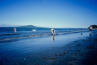
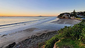
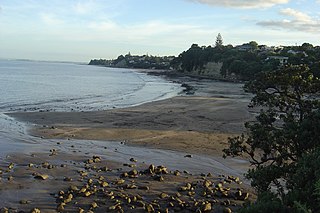
Castor Bay is a bay and suburb of the North Shore, located in Auckland which is in the North Island of New Zealand. Located between Milford and Campbells Bay, it is part of the East Coast Bays. To the east lies the islands of Rangitoto and Motutapu, which are easily visible from land. The suburb is in the North Shore ward, one of the thirteen administrative divisions of Auckland Council.

<span class="mw-page-title-main">Murrays Bay</span> Suburb in Auckland, New Zealand

Murrays Bay is a small suburb in the East Coast Bays region, located in the North Shore of Auckland. The suburb is roughly the same size as Rothesay Bay, the suburb to the immediate north. It is primarily a residential area but does have a community centre, restaurant and café. Murrays Bay is regularly serviced by buses which go to Takapuna and the Auckland city centre.

<span class="mw-page-title-main">Te Kawerau ā Maki</span> Māori iwi in New Zealand

Te Kawerau ā Maki, Te Kawerau a Maki, or Te Kawerau-a-Maki is a Māori iwi (tribe) of the Auckland Region of New Zealand. Predominantly based in West Auckland, it had 251 registered adult members as of June 2017. The iwi holds land for a new marae and papakāinga at Te Henga that was returned in 2018; and land for a secondary marae at Te Onekiritea that was returned in 2015. it has no wharenui yet.

<span class="mw-page-title-main">Long Bay, New Zealand</span> Suburb in Auckland, New Zealand

Long Bay is one of the northernmost suburbs of the North Shore, part of the contiguous Auckland metropolitan area located in New Zealand.

<span class="mw-page-title-main">Campbells Bay</span> Suburb in Auckland, New Zealand

Campbells Bay is a suburb of the North Shore located in Auckland, New Zealand.

This is a timeline of the history of the city of Auckland in New Zealand.

<span class="mw-page-title-main">Tāmaki Māori</span> Iwi in New Zealand

Tāmaki Māori are Māori iwi and hapū who have a strong connection to Tāmaki Makaurau, and whose rohe was traditionally within the region. Among Ngā Mana Whenua o Tāmaki Makaurau, also known as the Tāmaki Collective, there are thirteen iwi and hapū, organised into three rōpū (collectives), however Tāmaki Māori can also refer to subtribes and historical iwi not included in this list.

<span class="mw-page-title-main">Waiake</span> Suburb in Auckland, New Zealand

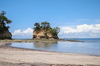
Waiake is one of the northernmost suburbs of the North Shore, in Auckland, New Zealand. It is located in the East Coast Bays between the suburbs of Browns Bay to the south and Torbay to the north. It has a beach, which looks out to the Tor, a presque-isle at the north end of the beach that becomes an island at high tide. Waiake is under the local governance of the Auckland Council.

<span class="mw-page-title-main">Schnapper Rock</span> Suburb in Auckland, New Zealand

Schnapper Rock is a suburb of Auckland, New Zealand, on the North Shore. The suburb is governed by Auckland Council. The area was known for a gum digging hut used by early European settlers in the mid-19th century. North Shore Memorial Park was opened area in 1974, and the area developed into suburban housing in the early 2000s.

<span class="mw-page-title-main">Baddeleys Beach-Campbells Beach</span> Place in Auckland Region, New Zealand

Baddeleys Beach and Campbells Beach are a contiguous settlement on adjacent beaches on the southern side of Tāwharanui Peninsula in the Auckland Region of New Zealand. The beaches are on Millon Bay, which is a part of Kawau Bay.

References

  1. 1 2 "Stats NZ Geographic Data Service". Statistical Area 2 2023 (generalised). Retrieved 27 December 2024.
  2. 1 2 "Aotearoa Data Explorer". Statistics New Zealand . Retrieved 26 October 2024.
  3. "Rothesay Bay". New Zealand Gazetteer. Land Information New Zealand. Retrieved 11 July 2023.
  4. Harriss, Gavin (March 2022). "NZ Topo Map" (Map). Rothesay Bay, Auckland.
  5. "Rothesay Bay". New Zealand Gazetteer. Land Information New Zealand. Retrieved 11 July 2023.
  6. 1 2 Heritage Consultancy Services (1 July 2011). North Shore Heritage - Thematic Review Report Volume 1 (PDF) (Report). Auckland Council. ISBN   978-1-927169-21-6 . Retrieved 29 June 2023.
  7. 1 2 Janssen, Peter (January 2021). Greater Auckland Walks. New Holland Publishers. p. 43-44. ISBN   978-1-86966-516-6. Wikidata   Q118136068.
  8. Veart, Dave (2018). The Māori Archaeology of Te Raki Paewhenua/North Shore (Report). Auckland North Community and Development. p. 10. ISBN   978-0-9941358-4-1.
  9. 1 2 Sheehan 2019, pp. 6.
  10. Pishief, Elizabeth; Shirley, Brendan (August 2015). "Waikōwhai Coast Heritage Study" (PDF). Auckland Council . Retrieved 14 February 2023.
  11. Ngāi Tai ki Tāmaki (April 2016). Cultural Values Assessment Report to New Zealand Transport Agency for Northern Corridor Improvements Project (NCI) (PDF) (Report). NZ Transport Agency . Retrieved 30 June 2023.
  12. Mossman, Sarah (August 2018). Cultural Values Assessment for America's Cup 36 - Wynyard and Hobson Planning Application (PDF). Te Kawerau Iwi Tribunal Authority (Report). Retrieved 30 June 2023.
  13. McKenzie, Fiona (June 2016). Cultural Impact Assessment for the NZ Transport Agency's Northern Corridor Improvements (PDF). Manuhiri Kaitiaki Charitable Trust (Report). NZ Transport Agency . Retrieved 30 June 2023.
  14. "Waitākere Ranges Heritage Area" (PDF). Auckland Council. December 2018. Retrieved 28 June 2021.
  15. Murdoch, Graeme (1990). "Nga Tohu o Waitakere: the Maori Place Names of the Waitakere River Valley and its Environs; their Background History and an Explanation of their Meaning". In Northcote-Bade, James (ed.). West Auckland Remembers, Volume 1. West Auckland Historical Society. pp. 13–14. ISBN   0-473-00983-8.
  16. Ngāti Manuhiri; The Crown (21 May 2011). "Deed of Settlement of Historical Claims" (PDF). New Zealand Government . Retrieved 18 May 2022.
  17. 1 2 Whaanga, Mel (March 2022). "He taonga o te rohe". Restore Hibiscus & Bays. Retrieved 30 June 2023.
  18. 1 2 Ngāi Tai Ki Tāmaki and the Trustees of the Ngāi Tai Ki Tāmaki Trust and the Crown (7 November 2015). "Deed of settlement schedule documents" (PDF). NZ Government. Archived (PDF) from the original on 13 February 2020. Retrieved 31 October 2021.
  19. 1 2 New Zealand Government; Ngāti Paoa (20 March 2021). "Ngāti Pāoa and the Trustees of the Ngāti Pāoa Iwi Trust and The Crown Deed of Settlement of Historical Claims" (PDF). New Zealand Government . Retrieved 1 September 2021.
  20. "Wenderholm Regional Park: Our History" (PDF). Auckland Council. 2015. Retrieved 4 May 2023.
  21. McKenzie, Fiona (May 2017). "Cultural Values Assessment for the Warkworth North Structure Plan and Associated Development" (PDF). Manuhiri Kaitiaki Charitable Trust. Auckland Council . Retrieved 4 July 2023.
  22. Ngāti Manuhiri; The Crown (21 May 2011). "Deed of Settlement of Historical Claims" (PDF). New Zealand Government . Retrieved 18 May 2022.
  23. Rigby, Barry (August 1998). The Crown, Maori and Mahurangi 1840-1881 (PDF) (Report). Waitangi Tribunal . Retrieved 4 July 2023.
  24. 1 2 Stone 2001, pp. 188.
  25. 1 2 Te Kawerau ā Maki; The Trustees of Te Kawerau Iwi Settlement Trust; The Crown (22 February 2014). "Deed of Settlement of Historical Claim" (PDF). Retrieved 4 July 2023.
  26. 1 2 3 4 Cass 1989, pp. 11–12.
  27. 1 2 3 4 Willis 2018, pp. 18–19.
  28. "Country News". The New Zealand Herald . Vol. XLIX, no. 15066. 8 August 1912. p. 4 via Papers Past.
  29. "Page 2 Advertisements Column 5". The New Zealand Herald . Vol. VII, no. 15905. 30 April 1915. p. 2 via Papers Past.
  30. Lutz, Heike; Chan, Theresa (2011). North Shore heritage – North Shore area studies and scheduled items list: volume 2 parts 6+ (PDF). Heritage Consultancy Services (Report). Auckland Council . Retrieved 7 July 2023.
  31. 1 2 Reidy, Jade (2009). "How the West Was Run". In Macdonald, Finlay; Kerr, Ruth (eds.). West: The History of Waitakere. Random House. pp. 238–239. ISBN   9781869790080.
  32. 1 2 Mace, Tania (October 2006). "Browns Bay Heritage Walk" (PDF). North Shore City Council . Retrieved 4 July 2023.
  33. Blakeley, Roger (2015). "The planning framework for Auckland 'super city': an insider's view". Policy Quarterly. 11 (4). doi: 10.26686/pq.v11i4.4572 . ISSN   2324-1101.
  34. "Statistical area 1 dataset for 2018 Census". Statistics New Zealand. March 2020. Rothesay Bay (119000). 2018 Census place summary: Rothesay Bay
  35. 1 2 3 "Totals by topic for individuals, (RC, TALB, UR, SA3, SA2, Ward, Health), 2013, 2018, and 2023 Censuses". Stats NZ – Tatauranga Aotearoa – Aotearoa Data Explorer. Rothesay Bay (119000). Retrieved 3 October 2024.
  36. "Totals by topic for dwellings, (RC, TALB, UR, SA3, SA2, Ward, Health), 2013, 2018, and 2023 Censuses". Stats NZ – Tatauranga Aotearoa – Aotearoa Data Explorer. Retrieved 3 October 2024.

Bibliography