
Hornby is a major residential and retail suburb at the western edge of Christchurch, New Zealand. The suburb is directly connected to other parts of Christchurch and the South Island by a number of main arterial routes, including State Highway 1 and the Christchurch Southern Motorway.
Avon United Football Club was a New Zealand amateur football club based in the city of Christchurch.

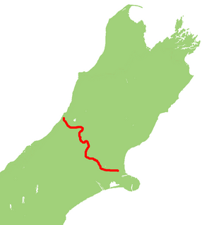
State Highway 1 is the longest and most significant road in the New Zealand road network, running the length of both main islands. It appears on road maps as SH 1 and on road signs as a white number 1 on a red shield, but it has the official designations SH 1N in the North Island, SH 1S in the South Island.

The Auckland Northern Motorway in the Auckland Region of New Zealand links central Auckland City and Puhoi in the former Rodney District via the Hibiscus Coast and North Shore. It is part of State Highway 1.
State Highway 20 (SH 20), also known as the Southwestern Motorway, is a New Zealand state highway linking State Highway 1 at Manukau with State Highway 16 in Point Chevalier, via Māngere and Onehunga. Along with its spurs, State Highway 20A and 20B, the state highway serves Auckland Airport, the country's largest, therefore making SH 20 a key arterial route connecting the airport to the wider Auckland region and most of the upper North Island. The route also forms the southern part of the Western Ring Route, a 48 kilometres (30 mi) motorway route bypassing central Auckland.

State Highway 3 (SH 3) is one of New Zealand's eight national state highways. It serves the west coast of the country's North Island and forms a link between State Highway 1 and State Highway 2. Distances are measured from north to south.

State Highway 2 runs north–south through eastern parts of the North Island of New Zealand from the outskirts of Auckland to Wellington. It runs via Tauranga in the Bay of Plenty, Gisborne, and Napier and Hastings in Hawke's Bay. It is the second-longest highway in the North Island, after State Highway 1, which runs the length of both of the country's main islands.
The Waikato Expressway is a dual carriageway section of State Highway 1 in the Waikato region of the North Island of New Zealand that is being constructed in stages. It forms part of the link between Auckland and Hamilton. When completed it will stretch 116 km (72 mi) and be 6 km (3.7 mi) shorter than the roads it replaced.

Woodend is a town in the Waimakariri District, in the Canterbury Region of the South Island of New Zealand. It may have been named because it was on the edge of what was then called the Maori Bush, or after an early settler, Thomas Wooding. It is situated with both the Waimakariri and Ashley Rivers running either side. Woodend is 6.6 kilometres north of Kaiapoi and 6.3 kilometres to the east of Rangiora. Woodend is within walking distance of the town of Pegasus.
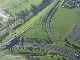
The Christchurch Southern Motorway is the main southern route into and out of Christchurch, New Zealand. The motorway forms part of State Highway 1 and State Highway 76.
Yaldhurst is a former New Zealand parliamentary electorate, near the city of Christchurch. The electorate was to the southwest of Christchurch, and was suburban and semi-rural.
The Christchurch Northern Motorway is the main northern route into and out of Christchurch, New Zealand. The motorway forms part of State Highway 1 and State Highway 74.
State Highway 73 is a major east-west South Island state highway in New Zealand connecting Christchurch on the east coast with Cass/Hokitika via the Southern Alps. It is mostly two lane, with some single-lane bridges north of Springfield but is mostly dual carriageway in Christchurch. The fourth and fifth-highest points of New Zealand's state highway network are on this road at Porters Pass and Arthur's Pass respectively.
State Highway 74 is a state highway in New Zealand servicing the eastern suburbs of Christchurch. Mostly two-lane, it is composed of limited-access expressways, with part of the highway as the Christchurch-Lyttelton Motorway, and connects the city to its port town of Lyttelton.
The Western Belfast Bypass is an approximately five-kilometre-long (3.1 mi), four lane, grade separated motorway recently built to bypass the northern Christchurch suburb of Belfast, New Zealand. It is estimated that its construction will result in 17,000 fewer vehicles using Main North Road through Belfast, and shorten travel times between the north and west of Christchurch. In addition, the motorway will allow for improved public transport, cycling, and pedestrian options on Main North Road. It is expected that 21,500 vehicles per day will use the WBB motorway by 2026. The speed limit along the route is 100 km/h.
State Highway 76 (SH 76) is a state highway in Christchurch, New Zealand. This highway was gazetted in 2012 after stage 1 of the Christchurch Southern Motorway was completed. Beforehand, much of SH 76 was part of SH 73 and included the former two-lane Christchurch Arterial Motorway, which was upgraded to four lanes. SH 76 includes the entire length of the Christchurch Southern Motorway and forms the most direct route from the south of Christchurch to the city centre and Lyttelton.

The Waterview Tunnel is a twin road tunnel in west Auckland, New Zealand. At 2,400 metres (7,900 ft) long, it is New Zealand's longest road tunnel. The tunnel, with three lanes of road vehicle traffic in each direction, connects State Highway 20 in the south at Mount Roskill to State Highway 16 in the west at Point Chevalier as part of the Waterview Connection. Its opening completed the Western Ring Route motorway system.
FC Twenty 11 is a New Zealand amateur football club based in the city of Christchurch. The club was formed in 2011 following the merger of Avon United and Burnside A.F.C.

Roads of National Significance (RoNS) was a name given by the 5th National Party Government, to a programme to speed up road construction in New Zealand between 2009 and 2017.
