New Zealand State Highway 17

Last updated

State Highway 17 NZ.svg

State Highway 17
Route information
Maintained by NZ Transport Agency
Length 32.9 km (20.4 mi)
Existed December 1999 – October 2012
Major junctions
North endState Highway 1 NZ.svg SH 1 at Puhoi
South endState Highway 1 NZ.svg SH 1 at Albany
Location
Primary
destinations
Waiwera, Orewa, Silverdale, Whangaparaoa Peninsula
Highway system
State Highway 16 NZ.svg SH 16 SH 18 State Highway 18 NZ.svg

State Highway 17 (SH 17) was the designation for a 32-kilometre stretch of highway in northern Auckland in the North Island of New Zealand from December 1999 to October 2012. It is now designated Urban Route 31 and consists of the Hibiscus Coast Highway, Dairy Flat Highway and Albany Expressway. It linked State Highway 1 (SH 1) at Puhoi in the north with SH 1 at Albany in the south. Its main destinations were the towns of (from north to south) Waiwera, Orewa, Red Beach, Whangaparaoa, Silverdale, Dairy Flat and the suburb of Albany. Prior to its inception as SH 17, the road was part of SH 1, and was redesignated as SH 17 as the Northern Motorway was extended northwards and took over the designation of SH 1.

Auckland Metropolitan area in North Island, New Zealand

Auckland is a city in the North Island of New Zealand. Auckland is the largest urban area in the country, with an urban population of around 1,628,900. It is located in the Auckland Region—the area governed by Auckland Council—which includes outlying rural areas and the islands of the Hauraki Gulf, resulting in a total population of 1,695,900. A diverse and multicultural city, Auckland is home to the largest Polynesian population in the world. The Māori-language name for Auckland is Tāmaki or Tāmaki-makau-rau, meaning "Tāmaki with a hundred lovers", in reference to the desirability of its fertile land at the hub of waterways in all directions.

North Island The northern of the two main islands of New Zealand

The North Island, also officially named Te Ika-a-Māui, is one of the two main islands of New Zealand, separated from the larger but much less populous South Island by Cook Strait. The island's area is 113,729 square kilometres (43,911 sq mi), making it the world's 14th-largest island. It has a population of 3,749,200.

Auckland urban route network Wikimedia list article

The Auckland urban route network consists of strategic and primary arterial roads across the Auckland Region of New Zealand. Urban routes are signposted with white shields. To avoid conflict with state highway numbering, there are no urban routes numbered 1, 2, 16, 18, 20, or 22.

Contents

History

SH 17 was part of SH 1 before the extension of the Northern Motorway in the late 1990s. Between December 1999 [1] and January 2009, SH 17 ran from present-day Exit 412 at Greville Road north through Albany and Dairy Flat to the interchange of SH 1, SH 1A and SH 17 at Silverdale (Exit 398).

When the SH 1 Northern Gateway Toll Road opened on 25 January 2009 it replaced both SH1's old route and SH 1A, and SH 17 was extended to replace the latter two roads, although this extension was not signposted.

State Highway 17 was revoked in October 2012 by the NZ Transport Agency because there was no need to maintain SH 1 and SH 17 as close together as they were, [2] especially as most long-distance traffic was taking the SH 1 toll road. Upon revocation, ownership of the road was transferred from the NZ Transport Agency to Auckland Council, with the road to be maintained by Auckland Transport. [2] The route became Urban Route 31.

The NZ Transport Agency is a New Zealand Crown entity tasked with promoting safe and functional transport by land, including the responsibility for driver and vehicle licensing, investigating rail accidents and administering the New Zealand state highway network. It was created on 1 August 2008 by the Land Transport Management Amendment Act 2008, merging Transit New Zealand with Land Transport New Zealand. Its legal name, as established by the Act, is New Zealand Transport Agency, but it operates as NZ Transport Agency. Its Māori name, Waka Kotahi, means "one vessel" and is intended to convey the concept of "travelling together as one".

Auckland Council Unitary territorial authority in Auckland, New Zealand

The Auckland Council is the local government council for the Auckland Region in New Zealand. The governing body consists of a mayor and 20 councillors, elected from 13 wards. There are also 149 members of 21 local boards who make decisions on matters local to their communities. It is the largest council in Oceania, with a $3 billion annual budget, $29 billion of ratepayer equity, and 9,870 full-time staff as of 30 June 2016. The council began operating on 1 November 2010, combining the functions of the previous regional council and the region's seven city and district councils into one "super council" or "super city".

Auckland Transport

Auckland Transport (AT) is the council-controlled organisation (CCO) of Auckland Council responsible for transport projects and services. It was established by section 38 of the Local Government Act 2009, and operates under that act and the Local Government Act 2010.

Route

SH 17 began at the junction with SH 1 just south of Puhoi, at Exit 388. While SH 17 officially started here, it was not signposted until its original (pre-toll road) terminus at Silverdale. SH17 wound over the Johnston Hill and down into the town of Waiwera. From here it became the Hibiscus Coast Highway and continued along the hills, coming down into Hatfields Beach and over another hill into Orewa township.

After crossing the Orewa River, SH 17 arrived at Red Beach, where there are intersections at Red Beach Road and Whangaparaoa Road for Whangaparaoa and other peninsula suburbs. Just outside Silverdale is the intersection with East Coast Road, a third route into Auckland city via Urban Route 25. Almost a kilometre after this is the interchange (Exit 398) with SH 1, the Northern Motorway and Northern Gateway Toll Road. From here SH 17 was signposted through to the city.

SH 17 continued through mostly rural countryside to Albany township, passing through Dairy Flat. Just outside Albany, the surface quality of the highway improves and Botts' dots replace painted lines on the road at the intersection with the Coatesville-Riverhead Highway. As the road enters Albany it becomes the Albany Expressway, running through the township until it meets the Albany Highway, whereupon it becomes a dual carriageway through to its terminus at Greville Road and SH 1.

Botts dots

Botts' dots are round non-reflective raised pavement markers. Botts' dots may also be called turtles or buttons. In many parts of the US and other countries, Botts' dots are used, along with reflective raised pavement markers, to mark lanes on highways and arterial roads. They provide tactile and auditory feedback to drivers when moving across designated travel lanes, and are analogous to rumble strips.

See also

Related Research Articles

Orewa human settlement

Orewa is a suburb of Auckland, New Zealand’s largest city. It lies on the Hibiscus Coast, just north of the base of the Whangaparaoa Peninsula and 40 kilometres north of central Auckland. Orewa's population was 8,523 in the 2013 Census, an increase of 1,197 from 2006. It is a popular holiday destination. Orewa is also considered one of the fastest growing places in New Zealand and is one of the most expensive areas in which to buy a house.

Whangaparaoa Peninsula

Whangaparaoa Peninsula is a suburban area about 25 km north of Auckland in New Zealand. It had 30,672 residents in 2013, many of them in the eponymous town of Whangaparaoa on its southern side. It is part of the Hibiscus Coast.

Dairy Flat Place in Auckland, New Zealand

Dairy Flat is a rural district 8 km south of Orewa beach in the North Island of New Zealand, 28 km north of central Auckland. Until the early 1990s most of the district was in dairy farms of 40 to 60 hectares, but with the growth of Auckland City and the extension of the Northern Motorway into the area, these are being gradually subdivided into lifestyle blocks of around 2 to 5 hectares, many of which are grazing sheep, horses, beef cattle or deer. Although it still retains a rural character, it is counted as part of the Auckland urban area in official statistics.

Hibiscus Coast

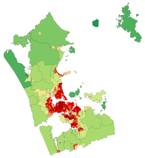
The Hibiscus Coast is a stretch of the Hauraki Gulf coast located in New Zealand's Auckland Region. It contains the northernmost part of the Auckland metropolitan area.

New Zealand State Highway 1 road in New Zealand

State Highway 1 is the longest and most significant road in the New Zealand road network, running the length of both main islands. It appears on road maps as SH 1 and on road signs as a white number 1 on a red shield, but it has the official designations SH 1N in the North Island, SH 1S in the South Island.

Northern Busway, Auckland

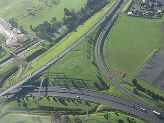
The Northern Busway is a segregated busway that runs along the eastern side of the Northern Motorway, part of State Highway 1, in the north of Auckland, New Zealand, linking the North Shore with the northern end of the Auckland Harbour Bridge. The busway consists of two-way lanes running between Constellation Station and Akoranga Station, and from Akoranga Station a southbound-only lane that joins the harbour bridge approaches just south of the Onewa Road on-ramp system.

Stillwater is a village in the northern end of Auckland in the North Island of New Zealand. Situated on the Weiti River immediately south of the Whangaparaoa Peninsula in the Rodney District, it is part of the area known as the Hibiscus Coast.

Silverdale, Auckland Place in Auckland, New Zealand

Silverdale is a village approximately 30 km north of Auckland in the North Island of New Zealand. It is located on the north bank of the Weiti River and lies to the west of the Whangaparaoa Peninsula. It was formerly called Wade but renamed Silverdale in 1911 because of the many poplar trees in the area at the time and because it is situated in a dale.

Penlink is the nickname for a proposed road which will create a more direct and quicker route between the Whangaparaoa Peninsula and central Auckland in New Zealand.

Auckland Northern Motorway road in New Zealand

The Auckland Northern Motorway in the Auckland Region of New Zealand links central Auckland City and Puhoi in the former Rodney District via the Hibiscus Coast and North Shore. It is part of State Highway 1.

New Zealand State Highway 20 road in New Zealand

State Highway 20, also known as the Southwestern Motorway, is a New Zealand state highway linking State Highway 1 at Manukau City Centre with State Highway 16 in Point Chevalier, via Mangere and Onehunga. Along with its spurs, State Highway 20A and 20B, the state highway serves Auckland Airport, the country's largest, therefore making State Highway 20 a key arterial route connecting the airport to the wider Auckland region and most of the upper North Island. The route also forms the southern part of the Western Ring Route, a 48 kilometres (30 mi) motorway route bypassing central Auckland. It is the only New Zealand State Highway that is entirely motorway.

Red Beach, New Zealand

Red Beach is a suburb surrounding the beach of the same name on the Hibiscus Coast, Auckland, New Zealand, at the base of the Whangaparaoa Peninsula. The suburb of Silverdale is to the south-west, and Orewa to the north. The beach is on the Hauraki Gulf and the suburb is bounded by two estuaries, that of the Weiti River to the south and the Orewa River to the north. The population was 6,432 in the 2013 census, an increase of 525 from 2006.

New Zealand State Highway 18 road in New Zealand

State Highway 18 is a state highway that runs between the Auckland Northern Motorway on the North Shore and the Northwestern Motorway in Waitakere in Auckland, New Zealand. The Upper Harbour Motorway forms most of its length as of 2016. SH 18 forms the northern part of the Western Ring Route, which continues from Waitakere south-east to Manukau.

The Western Ring Route is a motorway system being constructed in Auckland, New Zealand. It currently runs along the entire Southwestern Motorway, most of the Northwestern Motorway, the entire Upper Harbour Motorway, and the entire Upper Harbour Highway. When the Upper Harbour Highway is upgraded to motorway status, the route will surpass the Southern Motorway to become the longest motorway in New Zealand at 48 kilometres in length. It runs through Manukau, Waitakere, and the North Shore, bypassing the Auckland city centre and thus providing a second motorway route through the Auckland isthmus.

European route E71 road in Europe

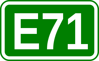
European route E 71 is a north-south Class-A intermediate European road route. It begins in Košice, Slovakia, passes through Budapest in Hungary, Zagreb in Croatia and Bihać in Bosnia and Herzegovina, and ends at Split in Croatia on the Adriatic Sea coast. The total length of the route is 1,016 km (631 mi). The E71 mostly consists of motorways, but considerable sections are either expressways or two-lane roads with at-grade intersections. Nearly all motorway sections of the E71 are tolled, using various toll collection systems including Electronic toll collection (ETC) and ticket systems. Individual segments of the E71 route are shared with several other European routes. The E71 section between Karlovac and Split is inconsistently physically signposted or marked on maps and route planning software. The E71 route has gradually been upgraded from a regular two-lane road to motorway standards since the 1970s; upgrades are still being carried out in some areas.

State Highway 22 (SH 22) is a New Zealand state highway just south of Auckland. It connects the town of Pukekohe to the Auckland Southern Motorway.

Albany Busway Station

Albany Busway Station is a bus station that is closely associated with Auckland's Northern Busway in New Zealand. It is located near Oteha Valley Road in the suburb of Albany. It has shelters, electronic real-time information on each platform, and park and ride parking. The busway lanes do not yet extend to this station from either the north or the south.

Hibiscus Coast Busway Station is a bus station that is closely associated with Auckland's Northern Busway in New Zealand. It is the northern terminus for services that run via the busway, but the busway lanes do not yet extend north to it. It is located on the Hibiscus Coast Highway a few hundred metres south-west of the village of Silverdale.

References

  1. "Auckland Motorways 2008" (PDF). NZ Transport Agency. Retrieved 2010-07-16.
  2. 1 2 "Big changes to Auckland's roading network". NZ Transport Agency. 1 October 2012. Retrieved 2 July 2016.