New Zealand State Highway 82

Last updated

State Highway 82 NZ.svg

State Highway 82
NZ-SH82 map.png
Route information
Maintained by NZ Transport Agency
Length 71 km (44 mi)
Major junctions
Northeast end SH 1 State Highway 1 NZ.svg at Hook
Southwest end Bledisloe Street State Highway 83 NZ.svg at Kurow
Location
Primary
destinations
Waimate
Highway system
State Highway 80 NZ.svg SH 80 SH 83 State Highway 83 NZ.svg

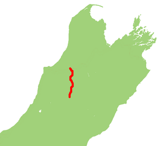
State Highway 82 (SH 82) is a minor east-west South Island state highway in South Canterbury connecting SH 1 at the locality of Hook to SH 83 at the settlement of Kurow in the Waitaki Valley via the major town of Waimate. It is a two lane single carriageway.

South Island Southernmost of the two main islands in New Zealand

The South Island, also officially named Te Waipounamu, is the larger of the two major islands of New Zealand in surface area; the other being the smaller but more populous North Island. It is bordered to the north by Cook Strait, to the west by the Tasman Sea, and to the south and east by the Pacific Ocean. The South Island covers 150,437 square kilometres (58,084 sq mi), making it the world's 12th-largest island. It has a temperate climate.

The New Zealand state highway network is the major national highway network in New Zealand. Nearly 100 roads in the North and South Islands are state highways. All state highways are administered by the NZ Transport Agency.

South Canterbury

South Canterbury is the name given semi-formally to the area of the Canterbury Region of the South Island of New Zealand bounded by the Rangitata River in the north and the Waitaki River to the south. The Pacific Ocean and ridge of the Southern Alps form natural boundaries to the east and west respectively. Though the exact boundaries of the region have never been formalised, the term is used for a variety of government agencies and other entities. It is one of four traditional sub-regions of Canterbury, along with Mid-Canterbury, North Canterbury, and Christchurch city.

Contents

SH 82 about to cross the Waitaki River north of Kurow Kurow State Highway 82.JPG
SH 82 about to cross the Waitaki River north of Kurow

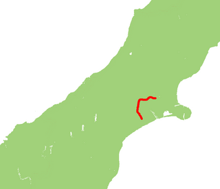
The highway crosses the Waitaki River and provides a vital link between Kurow and Hakataramea. SH 82 has for a long time been notable for two 130 year-old single lane bridges (256m and 140m long). SH 82 offers the only handy alternative route for motorists to reach destinations north and south of the Waitaki River and without these bridges motorists using SH 1 would face lengthy detours via the Mackenzie District. Dating back to 1881 and 1893, these aging structures were originally built as railway bridges but had recently reached the end of their serviceable lives. Extensive flood damage during December 1995/January 1996 that resulted in the closures of these bridges, highlighted their vulnerability to further flood damage.

Waitaki River river in New Zealand

The Waitaki River is a large braided river that drains the Mackenzie Basin and runs some 110 kilometres (68 mi) south-east to enter the Pacific Ocean between Timaru and Oamaru on the east coast of the South Island of New Zealand. It starts at the confluence of the Ohau River and the Tekapo River, now in the head of the artificial Lake Benmore, these rivers being fed by three large glacial lakes, Pukaki, Tekapo, and Ohau. The Waitaki flows through Lake Benmore, Lake Aviemore and Lake Waitaki, these lakes being contained by hydroelectric dams, Benmore Dam, Aviemore Dam and Waitaki Dam. The Waitaki has several tributaries, notably the Ahuriri River and the Hakataramea River. It passes Kurow and Glenavy before entering the Pacific Ocean.

In 2014 the bridges were upgraded to brand new two lane bridges along with a downstream cycle-pedestrian path. [1] Timber from the two 19th century bridges have been used to restore Helmores Lane Bridge in Christchurch, which has been damaged since the 2011 Christchurch earthquake. [2]

Christchurch Metropolitan area in South Island, New Zealand

Christchurch is the largest city in the South Island of New Zealand and the seat of the Canterbury Region. The Christchurch urban area lies on the South Island's east coast, just north of Banks Peninsula. It is home to 404,500 residents, making it New Zealand's third-most populous city behind Auckland and Wellington. The Avon River flows through the centre of the city, with an urban park located along its banks.

2011 Christchurch earthquake February 2011 earthquake in New Zealand

An Mw 6.2 earthquake occurred in Christchurch on 22 February 2011 at 12:51 p.m. local time. The earthquake struck the Canterbury Region in New Zealand's South Island and was centred two kilometres (1.2 mi) west of the port town of Lyttelton, and 10 kilometres (6 mi) south-east of the centre of Christchurch, at the time New Zealand's second-most populous city. The earthquake caused widespread damage across Christchurch, killing 185 people in the nation's fifth-deadliest disaster.

See also

Related Research Articles

New Zealand State Highway 1 road in New Zealand

State Highway 1 is the longest and most significant road in the New Zealand road network, running the length of both main islands. It appears on road maps as SH 1 and on road signs as a white number 1 on a red shield, but it has the official designations SH 1N in the North Island, SH 1S in the South Island.

New Zealand State Highway 65 road in New Zealand

State Highway 65 is a New Zealand state highway in the South Island. It is 71 km long and runs south to north down the Maruia river valley from SH 7 at Springs Junction, 15 km west of the main divide at the Lewis Pass, to SH 6 in the Buller Gorge, 11 km west of Murchison. It forms part of the most direct route between Christchurch and Nelson. It takes its name from a small settlement toward its northern end.

The Kurow Branch was part of New Zealand's national rail network. In the North Otago region of the South Island, it was built in the 1870s to open up the land behind Oamaru for development, and closed in 1983.

Hakataramea human settlement in New Zealand

Hakataramea, spelt Hakateramea in some older sources, is a rural village located in the southern Canterbury region of New Zealand's South Island. It is in the Waimate District and sits on the north bank of the Waitaki River at its confluence with the Hakataramea River.

New Zealand State Highway 8 road in New Zealand

State Highway 8 is one of New Zealand's eight national highways. It forms an anticlockwise loop through the southern scenic regions of the Mackenzie Basin and Central Otago, starting and terminating in junctions with State Highway 1. Distances are measured from north to south.

New Zealand State Highway 7 road in New Zealand

State Highway 7 is a major New Zealand state highway. One of the eight national highways, it crosses the Southern Alps to link the West Coast Region with Canterbury and to form a link between the South Island's two longest highways, State Highway 1 and State Highway 6. Distances are measured from east to west with the major junction list going from east to west.

New Zealand State Highway 6 road in New Zealand

State Highway 6 is a major New Zealand state highway. It extends from the northeastern corner of the South Island across the top of the island, then down the length of the island, initially along the West Coast and then across the Southern Alps through inland Otago and finally across the Southland Plains to the island's south coast. Distances are measured from north to south.

New Zealand State Highway 3 road in New Zealand

State Highway 3 (SH 3) is one of New Zealand's eight national state highways. It serves the west coast of the country's North Island and forms a link between State Highway 1 and State Highway 2. Distances are measured from north to south.

New Zealand State Highway 2 road in New Zealand

State Highway 2 runs north–south through eastern parts of the North Island of New Zealand from the outskirts of Auckland to Wellington. It runs via Tauranga in the Bay of Plenty, Gisborne, and Napier and Hastings in Hawke's Bay. It is the second-longest highway in the North Island, after State Highway 1, which runs the length of both of the country's main islands.

New Zealand State Highway 18 road in New Zealand

State Highway 18 is a state highway that runs between the Auckland Northern Motorway on the North Shore and the Northwestern Motorway in Waitakere in Auckland, New Zealand. The Upper Harbour Motorway forms most of its length as of 2016. SH 18 forms the northern part of the Western Ring Route, which continues from Waitakere south-east to Manukau.

New Zealand State Highway 73 road in New Zealand

State Highway 73 is a major east-west South Island state highway in New Zealand connecting Christchurch on the east coast with Cass/Hokitika via the Southern Alps. It is mostly two lane, with some single-lane bridges north of Springfield but is mostly dual carriageway in Christchurch. The fourth and fifth-highest points of New Zealand's state highway network are on this road at Porters Pass and Arthur's Pass respectively.

New Zealand State Highway 75 road in New Zealand

State Highway 75 (SH 75) is a state highway in New Zealand servicing the Banks Peninsula region, connecting Christchurch on the northwestern part of the peninsula with Akaroa towards the east coast. It is wholly two lane, but partially functions as a major arterial corridor of Christchurch. Its highest point is at Hilltop, where it rises to about 555 m - just 8 m lower than the more mountainous Haast Pass in the Southern Alps.

State Highway 74 is a state highway in New Zealand servicing the eastern suburbs of Christchurch. Mostly two-lane, it is composed of limited-access expressways, with part of the highway as the Christchurch-Lyttelton Motorway, and connects the city to its port town of Lyttelton.

New Zealand State Highway 77 road in New Zealand

State Highway 77 is a state highway in New Zealand going through the inland parts of Central and Mid Canterbury between the towns of Ashburton and Darfield via the Rakaia Gorge. It is wholly single carriageway with two one-lane bridges at the Rakaia and Selwyn Rivers. One set of traffic lights is found in Ashburton marking the southern terminus of the highway.

State Highway 80 is a South Island state highway in New Zealand. Known as Mount Cook Road, it is a tourist road between the settlements of Twizel and Mount Cook Village. About 55 kilometres in length, it is mostly two lane, with a few single-lane bridges. Tourists travelling between Christchurch and Queenstown often deviate here and travel to New Zealand's highest mountain Aoraki/Mount Cook.

New Zealand State Highway 83 road in New Zealand

State Highway 83 is a South Island state highway in New Zealand running up the Waitaki Valley between the settlements of Pukeuri and Omarama. It forms part of the southernmost of the east-west roads crossing the South Island.

State Highway 79 (SH 79) is a New Zealand state highway connecting the South Canterbury communities of Rangitata, Geraldine, and Fairlie. Starting at State Highway 1 the highway is 61 kilometres in length and runs in a general east-west direction. 6.3 km of the highway through Geraldine runs concurrently with the Inland Scenic Route, formerly State Highway 72. The road is a two-lane single carriageway, with a one-lane bridge crossing the Orari River.

State Highway 76 (SH 76) is a state highway in Christchurch, New Zealand. This highway was gazetted in 2012 after stage 1 of the Christchurch Southern Motorway was completed. Beforehand, much of SH 76 was part of SH 73 and included the former two-lane Christchurch Arterial Motorway, which was upgraded to four lanes. SH 76 includes the entire length of the Christchurch Southern Motorway and forms the most direct route from the south of Christchurch to the city centre and Lyttelton.

State Highway 25 is a North Island state highway in New Zealand that loops around the Coromandel Peninsula. It is a major route for holidaymakers and tourists which has access to some of New Zealand's most idyllic beach holiday spots. The summer period around Christmas and New Year's Eve is a particularly busy period for the highway. The road is very scenic, but also windy in many parts as well as single carriage on the entire route, and is prone to accidents. It is New Zealand's third longest two-digit state highway, after SH 35 and SH 94. It is part of the Pacific Coast Highway.

References

  1. "SH82 Waitaki River Bridges Replacement project". NZTA. Retrieved 4 February 2016.
  2. "Kurow bridge timbers travel north for rebuild of Christchurch bridge". NZ Transport Agency. 22 June 2016. Retrieved 23 June 2016.