New Zealand State Highway 61

Last updated

State Highway 61 NZ.svg

State Highway 61
Route information
Maintained by Tasman District Council
Length 58 km (36 mi)
Major junctions
North endState Highway 60 NZ.svg SH 60 at Motueka
South endState Highway 6 NZ.svg SH 6 at Kohatu Junction
Location
Primary
destinations
Tapawera
Highway system
State Highway 60 NZ.svg SH 60 SH 62 State Highway 62 NZ.svg

State Highway 61 (SH 61) is a former New Zealand state highway in the Tasman Region of the South Island. It links the coastal town of Motueka with SH 6, the main route to the South Island's West Coast. Along with several other state highways, its status was revoked at the beginning of the 1990s. [1] [2] The route is now usually referred to as the Motueka Valley Highway.

The New Zealand state highway network is the major national highway network in New Zealand. Nearly 100 roads in the North and South Islands are state highways. All state highways are administered by the NZ Transport Agency.

South Island Southernmost of the two main islands in New Zealand

The South Island, also officially named Te Waipounamu, is the larger of the two major islands of New Zealand in surface area; the other being the smaller but more populous North Island. It is bordered to the north by Cook Strait, to the west by the Tasman Sea, and to the south and east by the Pacific Ocean. The South Island covers 150,437 square kilometres (58,084 sq mi), making it the world's 12th-largest island. It has a temperate climate.

Motueka Town in Tasman District, New Zealand

The town of Motueka in the South Island of New Zealand lies close to the mouth of the Motueka River, on the western shore of Tasman Bay. It is, after Richmond, the second largest centre in the Tasman Region, with a population of 7125. The Motueka Ward had an estimated population of 10,900 at 30 June 2009.

Contents

Route description

SH 61 provided (and still provides, without its former status) a short-cut route for vehicles travelling between the Golden Bay and western Tasman Bay areas and the town of Westport, New Zealand and other parts of the West Coast and Buller. Rather than travelling south and then southeast from Motueka via SH 60 to join with SH 6 south of Richmond, motorists can cut a considerable distance from their journey by travelling in a more direct southerly direction.

Tasman Bay bay

Tasman Bay / Te Tai-o-Aorere, originally known as Blind Bay, is a large V-shaped bay at the north end of New Zealand's South Island. Located in the centre of the island's northern coast, it stretches along 120 kilometres (75 mi) of coastline and is 70 kilometres (43 mi) across at its widest point. It is an arm of the Tasman Sea, lying on the western approach to Cook Strait.

Westport, New Zealand Place in West Coast, New Zealand

Westport is a town in the West Coast region of the South Island of New Zealand. It is on the northern bank and at the mouth of the Buller River, close by the prominent headland of Cape Foulwind. It is connected via State Highway 6 with Greymouth, 100 kilometres (62 mi) to the south, and with Nelson 222 kilometres (138 mi) in the northeast, via the Buller Gorge.

Buller District Territorial authority in West Coast Region, New Zealand

Buller District is one of 53 districts of New Zealand, and is within the West Coast Region. It covers Westport, Karamea, Reefton and Inangahua Junction.

The former SH 61 largely follows the valley of the Motueka River. Starting just to the south of central Motueka, the route is initially due west along College Street, passing along the southern edge of Motueka Aerodrome. After about three kilometres, the highway reaches the Motueka River, and turns upstream, to the southwest. It passes through the small settlements of Ngatimoti and Woodstock, winding through a steep-sided valley before briefly leaving the river's edge. It rejoins the river after a further 5 km after passing through the small settlement of Stanley Brook. Shortly after rejoining the river, it passes through the township of Tapawera before reaching SH 6 at Kohatu Junction, close to the point where the Motueka River is joined by its tributary, the Motupiko River. Several of the small settlements along the highway's course are old gold mining towns from the 1860s Nelson Gold Rush, the first strike of which was at Waiwhero, just northeast of Ngatimoti. [3]

Motueka River river in New Zealand

The Motueka River is located in the north of the South Island of New Zealand and is a popular tourist destination for watersports and fishing. The Motueka flows 116 kilometres (72 mi) from the mountains 40 km west of the city of Nelson in the southeast of the catchment and flows north to the Tasman Bay.

Motueka Aerodrome airport in New Zealand

Motueka Aerodrome is the airport serving Motueka, New Zealand and is owned and managed by Tasman District Council.

Ngatimoti Place in New Zealand

Ngatimoti is a town near Motueka in New Zealand's South Island. Its Māori name means "of Timothy".

See also

Related Research Articles

Nelson, New Zealand City in Nelson City, New Zealand

Nelson is a city on the eastern shores of Tasman Bay. Nelson is the oldest city in the South Island and the second-oldest settled city in New Zealand – it was established in 1841 and was proclaimed a city by royal charter in 1858.

Tasman District Place in New Zealand

Tasman District is a local government district in the north of the South Island of New Zealand. It borders the Canterbury Region, West Coast Region, Marlborough Region and Nelson City. It is administered by the Tasman District Council, a unitary authority, which sits at Richmond, with community boards serving outlying communities in Motueka and Golden Bay / Mohua.

New Zealand State Highway 65 road in New Zealand

State Highway 65 is a New Zealand state highway in the South Island. It is 71 km long and runs south to north down the Maruia river valley from SH 7 at Springs Junction, 15 km west of the main divide at the Lewis Pass, to SH 6 in the Buller Gorge, 11 km west of Murchison. It forms part of the most direct route between Christchurch and Nelson. It takes its name from a small settlement toward its northern end.

Interstate 84 (I-84) in the U.S. state of Idaho is a major Interstate Highway that traverses the state from the Oregon line in the northwest to Utah in the southeast. It primarily follows the Snake River across a plain that includes the cities of Boise, Mountain Home, and Twin Falls. The highway is one of the busiest in Idaho and is designated as the Vietnam Veterans Memorial Highway.

New Zealand State Highway 8 road in New Zealand

State Highway 8 is one of New Zealand's eight national highways. It forms an anticlockwise loop through the southern scenic regions of the Mackenzie Basin and Central Otago, starting and terminating in junctions with State Highway 1. Distances are measured from north to south.

New Zealand State Highway 6 road in New Zealand

State Highway 6 is a major New Zealand state highway. It extends from the northeastern corner of the South Island across the top of the island, then down the length of the island, initially along the West Coast and then across the Southern Alps through inland Otago and finally across the Southland Plains to the island's south coast. Distances are measured from north to south.

State Highway 93 is a New Zealand State Highway connecting the Southland township of Mataura with the Western Otago town of Clinton. This provides a slightly quicker route between the cities of Dunedin and Invercargill, as it bypasses the town of Gore. It is roughly 43.2 km long.

New Zealand State Highway 94 road in New Zealand

State Highway 94 is a New Zealand state highway connecting the large Southland town of Gore with one of New Zealand's most popular destinations, Milford Sound. It also passes the significant townships of Lumsden and Te Anau as well going through the Homer Tunnel. The road also goes through Fiordland and crosses the Main Divide of the Southern Alps.

New Zealand State Highway 73 road in New Zealand

State Highway 73 is a major east-west South Island state highway in New Zealand connecting Christchurch on the east coast with Cass/Hokitika via the Southern Alps. It is mostly two lane, with some single-lane bridges north of Springfield but is mostly dual carriageway in Christchurch. The fourth and fifth-highest points of New Zealand's state highway network are on this road at Porters Pass and Arthur's Pass respectively.

New Zealand State Highway 63 road in New Zealand

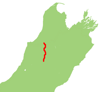
State Highway 63 is a state highway located in the northern parts of the South Island of New Zealand. It is 117 km long and runs between the settlements of Renwick and Kawatiri Junction via Saint Arnaud, providing a bypass of the city of Nelson. Despite being a convenient link between the West Coast and Marlborough, and being a relatively straight highway along most of its length, it is only classified by the NZTA as a secondary collector highway.

State Highway 80 is a South Island state highway in New Zealand. Known as Mount Cook Road, it is a tourist road between the settlements of Twizel and Mount Cook Village. About 55 kilometres in length, it is mostly two lane, with a few single-lane bridges. Tourists travelling between Christchurch and Queenstown often deviate here and travel to New Zealand's highest mountain Aoraki/Mount Cook.

New Zealand State Highway 83 road in New Zealand

State Highway 83 is a South Island state highway in New Zealand running up the Waitaki Valley between the settlements of Pukeuri and Omarama. It forms part of the southernmost of the east-west roads crossing the South Island.

New Zealand State Highway 60 road in New Zealand

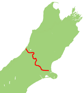
State Highway 60 is a state highway servicing the far northwest of the South Island of New Zealand. Running between the settlements of Richmond and Collingwood, it is 116 kilometres (72 mi) long and lies entirely within the Tasman District. It is the northernmost highway in the South Island and is a popular tourist route, servicing Motueka, Abel Tasman National Park, Golden Bay, and Farewell Spit.

New Zealand State Highway 29 road in New Zealand

State Highway 29 (SH 29) is a New Zealand state highway that travels over the Kaimai Ranges linking the Bay of Plenty and Waikato regions. For most of its length, SH 29 is a two-lane single carriageway with occasional passing lanes and slow vehicle bays. 5 km of it near its eastern terminus is part of the Takitimu Drive Toll Road.

Provincial Highway 40 was part of the New Zealand state highway network before it was revoked in 1991-92.

Provincial (State) Highway 91 was part of the New Zealand state highway network before briefly becoming part of SH 92 in 1990–91. It ran for 13 kilometres through South Otago in the southern South Island. SH 92 itself had its status revoked a year later.

References

  1. "Traffic Volumes" (PDF). Transit New Zealand. 1990. ISSN   0112-3165 . Retrieved 7 December 2015.
  2. "Traffic Volumes" (PDF). Transit New Zealand. 1991. ISSN   0112-3165 . Retrieved 7 December 2015.
  3. Whelan, H. (1990) "Gold Rush in Waiwhero", in Journal of the Nelson and Marlborough Historical Societies, 2:4. Retrieved 7 December 2015.