
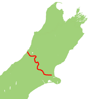
State Highway 7 is a major New Zealand state highway. One of the eight national highways, it crosses the Southern Alps to link the West Coast Region with Canterbury and to form a link between the South Island's two longest highways, State Highway 1 and State Highway 6. Distances are measured from east to west with the major junction list going from east to west.

State Highway 6 is a major New Zealand state highway. It extends from the northeastern corner of the South Island across the top of the island, then down the length of the island, initially along the West Coast and then across the Southern Alps through inland Otago and finally across the Southland Plains to the island's south coast. Distances are measured from north to south.

State Highway 5 is the second shortest of New Zealand's eight national highways. It extends from SH 1 at Tirau, on the plains of the Waikato River, to SH 2, close to the Hawke Bay coast at Bay View, 10 km north of Napier. Distances are measured from north to south.

State Highway 3 (SH 3) is one of New Zealand's eight national state highways. It serves the west coast of the country's North Island and forms a link between State Highway 1 and State Highway 2. Distances are measured from north to south.

State Highway 4 is the shortest of New Zealand's eight national highways. It runs north-south across rugged hill country, forming a short cut between two points on State Highway 3 thereby avoiding Taranaki and the coasts of the North and South Taranaki Bights. Distances are measured from north to south.

State Highway 2 runs north–south through eastern parts of the North Island of New Zealand from the outskirts of Auckland to Wellington. It runs via Tauranga in the Bay of Plenty, Gisborne, and Napier and Hastings in Hawke's Bay. It is the second-longest highway in the North Island, after State Highway 1, which runs the length of both of the country's main islands.

State Highway 30 (SH 30) is a New Zealand state highway, linking the Waikato and Bay of Plenty towns of Te Kuiti, Mangakino, Rotorua, and Whakatane.

State Highway 94 is a New Zealand state highway connecting the large Southland town of Gore with one of New Zealand's most popular destinations, Milford Sound. It also passes the significant townships of Lumsden and Te Anau as well going through the Homer Tunnel. The road also goes through Fiordland and crosses the Main Divide of the Southern Alps.
State Highway 73 is a major east-west South Island state highway in New Zealand connecting Christchurch on the east coast with Cass/Hokitika via the Southern Alps. It is mostly two lane, with some single-lane bridges north of Springfield but is mostly dual carriageway in Christchurch. The fourth and fifth-highest points of New Zealand's state highway network are on this road at Porters Pass and Arthur's Pass respectively.

State Highway 75 (SH 75) is a state highway in New Zealand servicing the Banks Peninsula region, connecting Christchurch on the northwestern part of the peninsula with Akaroa towards the east coast. It is wholly two lane, but partially functions as a major arterial corridor of Christchurch. Its highest point is at Hilltop, where it rises to about 555 m - just 8 m lower than the more mountainous Haast Pass in the Southern Alps.
State Highway 63 is a state highway located in the northern parts of the South Island of New Zealand. It is 117 km long and runs between the settlements of Renwick and Kawatiri Junction via Saint Arnaud, providing a bypass of the city of Nelson. Despite being a convenient link between the West Coast and Marlborough, and being a relatively straight highway along most of its length, it is only classified by the NZTA as a secondary collector highway.

State Highway 83 is a South Island state highway in New Zealand running up the Waitaki Valley between the settlements of Pukeuri and Omarama. It forms part of the southernmost of the east-west roads crossing the South Island.

State Highway 57 is a New Zealand state highway, linking State Highway 1 north of Ohau to State Highway 3 east of Ashhurst, via Levin, Shannon, Massey University and the southern suburbs of Palmerston North. The highway connects State Highway 1 traffic coming north from Wellington to the city of Palmerston North, and further to the Manawatu Gorge, allowing passage to the eastern side of the North Island and to the twin cities of Napier and Hastings. The highway is classified by the NZTA as a national strategic road.

State Highway 87 is a state highway in New Zealand servicing the Taieri Plains and the Strath-Taieri Valley in Otago, connecting Mosgiel to Kyeburn on the eastern flank of the Maniototo Plains.
State Highway 35 (SH 35) is a New Zealand state highway on the East Coast of the North Island. It is the main highway that services the East Cape of New Zealand as well as many other rural towns such as Hicks Bay, Ruatoria, Tolaga Bay, and the city of Gisborne.
State Highway 25 is a North Island state highway in New Zealand that loops around the Coromandel Peninsula. It is a major route for holidaymakers and tourists which has access to some of New Zealand's most idyllic beach holiday spots. The summer period around Christmas and New Year's Eve is a particularly busy period for the highway. The road is very scenic, but also windy in many parts as well as single carriage on the entire route, and is prone to accidents. It is New Zealand's third longest two-digit state highway, after SH 35 and SH 94. It is part of the Pacific Coast Highway.
State Highway 14 is a New Zealand state highway in the north of the North Island. It forms an east to west connection between SH 1 and SH 12. It runs to the west coast of the Northland Region of New Zealand.
State Highway 61 (SH 61) is a former New Zealand state highway in the Tasman Region of the South Island. It links the coastal town of Motueka with SH 6, the main route to the South Island's West Coast. Along with several other state highways, its status was revoked at the beginning of the 1990s. The route is now usually referred to as the Motueka Valley Highway.
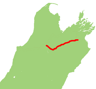
The Inland Kaikoura Road, formerly designated State Highway 70, is a provincial highway in the South Island of New Zealand that runs from just south of Kaikoura to just north of Culverden via Waiau and Rotherham. White shields are used to signify this highway. It forms part of the Alpine Pacific Triangle tourist route. It also serves as an alternative inland route in cases where SH 1 is closed near the South Kaikoura coast. Following the 2016 Kaikoura earthquake, all roads into Kaikoura were closed including Route 70; it was the first road connection to Kaikoura to reopen in mid-December.


