
Waipoua Forest is a forest, on the west coast of the Northland Region of New Zealand's North Island. It preserves some of the best examples of kauri forest remaining in New Zealand. It is notable for having two of the largest living kauri trees, Tāne Mahuta and Te Matua Ngahere.
Skelton Glacier is a large glacier flowing from the polar plateau into the Ross Ice Shelf at Skelton Inlet on the Hillary Coast, south of Victoria Land, Antarctica.

The Cavalli Islands are a small group of islands near Whangaroa on Northland's East Coast in northern New Zealand. They lie 3 kilometres (1.9 mi) to the east of Matauri Bay on the mainland.
Conservation park is a type of specially protected land status held by the Crown in New Zealand for conservation purposes. The status is established under the Conservation Act 1987 and the parks are administered by the Department of Conservation (DoC).
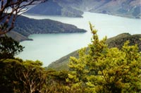
Fairy Bay is east of Mount Stanley, elevation 971 metres (3,186 ft), in Pelorus Sound / Te Hoiere, part of the Marlborough Sounds Maritime Park, at the top of the South Island, New Zealand. The origin of the name is thought to have been the fairy penguin. It has previously been known as Falls River Bay and Sandfly Bay. A neighbouring bay immediately to the south is called Penguin Bay.
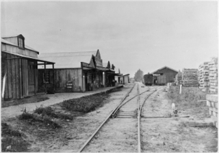
The Donnellys Crossing Section, also known as the Kaihu Valley Railway or Kaihu Branch, was a railway line in Northland, New Zealand. Initially an isolated line of 35.91 kilometres (22.31 mi), it became a branch line when the Dargaville Branch was opened and connected it with the North Auckland Line and the rest of the national rail network in 1943. The branch was closed in 1959.
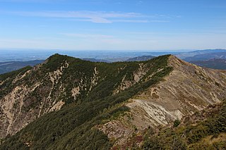
The Maungataniwha Range is a volcanic mountain range located in Northland Region of New Zealand. The Mangamukas, as it is known by the local residents and many Northlanders because of the name of the settlement and river on the southern side, separates Kaitaia and the Aupouri Peninsula from the rest of Northland. The highest point in the Maungataniwha Ranges is Raetea at 744m. The range is home to many kauri trees and part of the range is a part of Northland Forest Park.
Mangamuka is a district in Northland, New Zealand, at the junction of the Mangamuka and Opurehu Rivers. State Highway 1 runs through the area, and the settlement of Mangamuka Bridge lies at the point where the highway crosses the Mangamuku River. The river runs into the upper Hokianga Harbour. Just to the north west, the highway runs through Mangamuka Gorge in the Maungataniwha Range. Umawera lies to the south east.
Matihetihe is a community in the Hokianga area of Northland, New Zealand. The Warawara Forest lies to the north. The Matihetihe Stream runs into the Tasman Sea to the west. The locality is named for the tihetihe tumbleweed that grows in the local sand dunes. Matehetihe is part of the Hokianga North statistical area. For demographics of this area, see Panguru.
Whirinaki is a locality on the Whirinaki River in the south Hokianga, in Northland, New Zealand. The name means "to lean against a support". Highway 12 runs through it. Opononi lies to the south west, and Rawene lies to the north east.
Kaihu is a locality and settlement in Northland, New Zealand. The Kaihu River runs through the Kaihu Valley into the Wairoa River near Dargaville, approximately 32 km south east. State Highway 12 runs along the valley and passes through Kaihu settlement. Aranga is about 10 km north west. The Kaihu Forest is to the east and the Marlborough Forest is to the north.
The Cam River is a river of New Zealand. It flows north from the Inland Kaikoura Range and is a tributary of the Awatere River.
The Mangakahia River is a river of the Northland Region of New Zealand's North Island. It flows east from its sources in the Mataraua Forest, turning southeastward after about 20 kilometres (12 mi) on joining with the small Awarua River. It is joined by the Opouteke River near Pakotai, then turns east, until it is joined by the Hikurangi River. It then turns south again, passing Titoki and then joining with the Wairua River to form the Wairoa River approximately halfway between Whangārei and Dargaville.
The Mangapa River is a river of the far north of New Zealand's North Island. It flows south from its sources in the Omahuta Forest to reach the Waipapa River 25 kilometres (16 mi) west of Kerikeri.

The Medway River is a river of the Marlborough Region of New Zealand's South Island. It flows northwest then north from its sources in the Inland Kaikoura Range to meet the Awatere River 20 kilometres (12 mi) southwest of Seddon.
The Tākou River is a river of the Northland Region of New Zealand's North Island. It flows generally east from its sources east of Kaeo to reach the Pacific Ocean at Tākou Bay, 14 km (8.7 mi) north of Kerikeri.
The Crown Hills are a group of peaks and hills forming the south-east part of the Lanterman Range in the Bowers Mountains of Victoria Land, Antarctica. Lying between Zenith Glacier and Gambone Peak, and including All Black Peak, they rise to a height of 2,000 metres (6,600 ft). The name was given by the New Zealand Antarctic Place-Names Committee (NZ-APC) in 1983, at the suggestion of geologist M.G. Laird, in association with nearby Coronet Peak.

State Highway 12 is a New Zealand state highway in the far north of the North Island. It connects with SH 1 at both its northern and southern end. It runs close to the west coast of the Northland Region of New Zealand.
Northland Conservation Park is a group of protected areas in the Northland Region of New Zealand's North Island.
The Kaihu Forest is a forested area located in the Northland region of New Zealand, near the Kaihu River and the settlement of Kaihu. The forest is part of the broader ecological landscape of the region, which historically included vast stands of native Kauri trees, one of New Zealand’s most iconic tree species.

