
The Northland Region is the northernmost of New Zealand's 16 local government regions. New Zealanders sometimes refer to it as the Winterless North because of its mild climate all throughout the year. The main population centre is the city of Whangārei, and the largest town is Kerikeri. At the 2018 New Zealand census, Northland recorded a population growth spurt of 18.1% since the previous 2013 census, placing it as the fastest growing region in New Zealand, ahead of other strong growth regions such as the Bay of Plenty Region and Waikato.

Kaipara District is a territorial authority district in the Northland Region of New Zealand.

Dargaville is a town located in the North Island of New Zealand. It is situated on the bank of the Northern Wairoa River in the Kaipara District of the Northland region. Dargaville is located 55 kilometres (34 mi) southwest of Whangārei, and 174 kilometres (108 mi) north of Auckland.

Kaipara Harbour is a large enclosed harbour estuary complex on the north western side of the North Island of New Zealand. The northern part of the harbour is administered by the Kaipara District and the southern part is administered by the Auckland Council. The local Māori tribe is Ngāti Whātua.
Tangiteroria is a small rural community in the North Island of New Zealand. It is located halfway between Whangārei and Dargaville on State Highway 14 on the banks of the Northern Wairoa river.

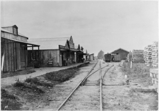
The Dargaville Branch is a branch line railway that leaves the North Auckland Line not far south of Whangarei and runs westward to Dargaville. Construction of this relatively short line took approximately two decades, and when it was completed, it linked the now closed Donnellys Crossing Section with the national rail network. The branch has been closed to all traffic since 2014 and is currently used by a tourist railcart operation.

Ruawai is a small town located 30 km south of Dargaville in Northland, New Zealand.
Aranga is a locality in Northland, New Zealand. State Highway 12 passes through it. Ōmāpere is 47 km northwest, and Dargaville is 42 km southeast. The Waipoua Forest is to the north. Maunganui Bluff and the Tasman Sea are to the west, with the small settlement of Aranga Beach lying at the northern end of Ripiro Beach.
Kaihu is a locality and settlement in Northland, New Zealand. The Kaihu River runs through the Kaihu Valley into the Wairoa River near Dargaville, approximately 32 km south east. State Highway 12 runs along the valley and passes through Kaihu settlement. Aranga is about 10 km north west. The Kaihu Forest is to the east and the Marlborough Forest is to the north.
Tangowahine is a community on the northern Kaipara Harbour in Northland, New Zealand. The Tangowahine Stream flows from the Tutamoe Range east and then south to join the Wairoa River at Tangowahine. State Highway 14 passes through Tangowahine. Dargaville is 12 km to the south west, and Tangiteroria is 15 km north east.
Te Kōpuru is the largest community on the Pouto Peninsula in Northland, New Zealand. The Wairoa River separates the peninsula at this point from the main North Auckland Peninsula to the east. Dargaville is 14 km (8.7 mi) to the north.
The Mangakahia River is a river of the Northland Region of New Zealand's North Island. It flows east from its sources in the Mataraua Forest, turning southeastward after about 20 kilometres (12 mi) on joining with the small Awarua River. It is joined by the Opouteke River near Pakotai, then turns east, until it is joined by the Hikurangi River. It then turns south again, passing Titoki and then joining with the Wairua River to form the Wairoa River approximately halfway between Whangarei and Dargaville.
The Waiotama River is a river of the Northland Region of New Zealand's North Island. It flows northwest from its origins south of Maungatapere to reach the Wairoa River 20 kilometres northeast of Dargaville.
The Wairua River is a river of Northland, New Zealand. It flows south-west from Hikurangi and joins the Mangakahia River between Titoki and Tangiteroria to form the Wairoa River, which runs past Dargaville to the Kaipara Harbour.
The Kauri Museum is in the west coast village of Matakohe, Northland, New Zealand. The museum, to the south of the Waipoua Forest, contains many exhibits that tell the story of the pioneering days when early European settlers in the area extracted kauri timber and kauri gum.

State Highway 12 is a New Zealand state highway in the far north of the North Island. It connects with SH 1 at both its northern and southern end. It runs close to the west coast of the Northland Region of New Zealand.

Trounson Kauri Park is a mainland island in the Northland Region of New Zealand. Characterised by its kauri trees, it was named after James Trounson, who gifted the forest to the Department of Conservation.

The Twin Coast Discovery Highway is an 800-kilometre (500 mi) circular road route of Northland, a region located in New Zealand. Most of the route travels on part of State Highway 1 (SH 1), the longest and major road in New Zealand, but some parts spur off onto other roads. It is commonly used as a tourist route, most of the time to visit Cape Reinga. The name "Twin Coast Discovery" is so named because the route up to and back from Cape Reinga are on different coasts.
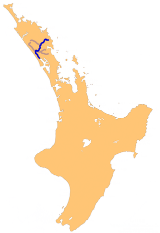
The Awakino River is a river of the Kaipara District in Northland Region. It flows 38 km (24 mi), generally south from the Awakino Stream, which rises on the Tutāmoe Range, to reach the Wairoa River on the eastern edge of Dargaville. The river is crossed by SH14 and the mothballed Dargaville Branch railway.
Hobson County was one of the counties of New Zealand in the North Island, from 1876 until 1989. It came into existence in November 1876, when the provinces were abolished. The county seat was at Aratapu, on the western bank of the Wairoa River, 9.5 kilometres (5.9 mi) south of Dargaville, until 1909, when it moved to Dargaville. In 1908, the town of Dargaville and neighboroughing Mangawhare split from Hobson County to form Dargaville Borough. In the 1989 local government reforms, Hobson County re-amalgamated with Dargaville Borough and merged with Otamatea County and parts of Rodney County and Whangarei County to create Kaipara District.


