Ohaeawai is a small village at the junction of State Highway 1 and State Highway 12 in the Far North District of New Zealand, some 250km (160mi) from Auckland. The town of Kaikohe is 10.4km (6.5mi) to the west, and the Bay of Islands is a short drive to the east.
Nearby is the site of the bloody Battle of Ohaeawai fought at Pene Taui's pā (fort) during the Flagstaff War in 1845. The therapeutic mercurial waters of the minor health spa of Ngawha Springs are in a small thermal area to the west, where Northland prison is situated. The village is the centre of a rich farming district as a result of the fertile volcanic soils, with the district known to the Ngāpuhi as Tai-a-mai.[2]
St Michael's Church, Ohaeawai
Taiamai was the name given to a large boulder of volcanic rock situated about 400 m (quarter mile) south east of the Ohaeawai hotel. This prominent rock stands about 3.5 metres (11ft) high, and was formerly an uruuru whenua, a place where travellers recited a charm and placed a small offering, such as a branch or tuft of grass, in order to placate the spirits of that place.[2]
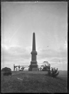
In 1845 Te Ruki Kawiti and Pene Taui fortified Taui's pā (fort), which British forces laid siege to in July that year. The outcome of the Battle of Ohaeawai is considered to be a defeat of the British colonial forces. St. Michael's Anglican Church was built in 1870 on the site of the pā.[3]
St. Michael's Anglican Church is 7.2km (4.5mi) from Kaikohe and 3.2km from the township of Ohaeawai, situated on a gentle rise a short distance west of the main road.[4] In August 2018 the battleground area around the church, including the urupa (cemetery), was added to the Heritage New Zealand list as a wāhi tapu, a place sacred to the Ngati Hine iwi and of historic significance.[5]
The locality is usually called Ngawha, from the hot springs in the neighbourhood. Cowan (1922) asserts that the site of the church (and earlier pā) is the true Ohaeawai and the European township which has appropriated the name should properly be known as Taiamai.[6]
The 2013 New Zealand census recorded Ohaeawai's population as 714, an increase of 3 people since the 2006 census.[7]
The Flagstaff War, also known as Heke's War, Hōne Heke's Rebellion and the Northern War, was fought between 11 March 1845 and 11 January 1846 in and around the Bay of Islands, New Zealand. The conflict is best remembered for the actions of Hōne Heke who challenged the authority of the British by cutting down the flagstaff on Flagstaff Hill at Kororāreka, now Russell. The flagstaff had been a gift from Hōne Heke to James Busby, the first British Resident. The Northern War involved many major actions, including the Battle of Kororāreka on 11 March 1845, the Battle of Ohaeawai on 23 June 1845 and the siege of Ruapekapeka Pā from 27 December 1845 to 11 January 1846.
The Battle of Ohaeawai was fought between British forces and local Māori during the Flagstaff War in July 1845 at Ohaeawai in the North Island of New Zealand. Te Ruki Kawiti, a prominent rangatira (chief) was the leader of the Māori forces. The battle was notable in that it established that the fortified pā could withstand bombardment from cannon fire and that frontal assaults by soldiers would result in serious troop losses.
Tāmati Wāka Nene was a Māori rangatira (chief) of the Ngāpuhi iwi (tribe) who fought as an ally of the British in the Flagstaff War of 1845–46.
Te Ruki Kawiti was a prominent Māori rangatira (chief). He and Hōne Heke successfully fought the British in the Flagstaff War in 1845–46.
Hōne Wiremu Heke Pōkai, born Heke Pōkai and later often referred to as Hōne Heke, was a highly influential Māori rangatira (chief) of the Ngāpuhi iwi (tribe) and a war leader in northern New Zealand; he was affiliated with the Ngati Rahiri, Ngai Tawake, Ngati Tautahi, Te Matarahurahu and Te Uri-o-Hua hapu (subtribes) of Ngāpuhi. Hōne Heke fought with Hongi Hika, an earlier war leader of the Ngāpuhi, in the Musket Wars. Hōne Heke is considered the principal instigator of the Flagstaff War in 1845–46.
Ngāpuhi is a Māori iwi located in the Northland region of New Zealand, and centred in the Hokianga, the Bay of Islands, and Whangarei.
Ngāti Whātua is a Māori iwi (tribe) of the lower Northland Peninsula of New Zealand's North Island. It comprises a confederation of four hapū (subtribes) interconnected both by ancestry and by association over time: Te Uri-o-Hau, Te Roroa, Te Taoū, and Ngāti Whātua-o-Ōrākei. The four hapū can act together or separately as independent tribes.
Kaikohe is a town in the Far North District of New Zealand, situated on State Highway 12 about 260 km from Auckland. It is the largest inland town and highest community above sea level in the Northland Region. With a population of just under 4000 people it is a shopping and service centre for an extensive farming district and is sometimes referred to as "the hub of the north".
Taipa-Mangonui or Taipa Bay-Mangonui is a string of small resort settlements – Taipa, Cable Bay, Coopers Beach, and Mangonui – that lie along the coast of Doubtless Bay and are so close together that they have run together to form one larger settlement. The area had a combined population in 2013 of 1662.
Ngawha Springs is a small settlement approximately five kilometres east of the town of Kaikohe, Northland in New Zealand.
Kaeo is a township in the Far North District of New Zealand, located some 22 km (14 mi) northwest of Kerikeri. The town takes its name from the kāeo or New Zealand freshwater mussel, which is found in the nearby rivers.
Waimate North is a small settlement in Northland, New Zealand. It is situated between Kerikeri and Lake Omapere, west of the Bay of Islands.
Pakaraka is a settlement in Northland, New Zealand, at the junction of State Highway 1 and 10, in the district the Ngāpuhi tribe called Tai-a-mai.
Tautoro is a locality about 8 km south-southeast of Kaikohe in Northland, New Zealand. Further to the south is the Awarua rural community.
Whirinaki is a locality on the Whirinaki River in the south Hokianga, in Northland, New Zealand. The name means "to lean against a support". Highway 12 runs through it. Opononi lies to the south west, and Rawene lies to the north east.
Whangape Harbour is a harbour on the west coast of Northland, New Zealand. There is a settlement called Whangape on the northern side of the harbour. Another, called Pawarenga, is located on the southern side. Kaitaia is 42 km north east.
Pakotai is a locality in the Mangakahia River Valley of Northland, New Zealand. Kaikohe is about 37 km to the north, and Maungatapere is about 34 km to the south east.
Te Wera Hauraki (?–1839) was a notable New Zealand tribal leader. Of Māori descent, he identified with the Nga Puhi iwi. Hauraki was the son of Kaitara, a leader of Ngāti Hineira and Te Uri Taniwha, of Nga Puhi. He lived in Pukenui pa, Te Ahuahu, in the Bay of Islands in his youth. Hauraki and his brother Te Kopiri fought as young men in the battle fought by Whaingaroa to drive Ngati Pou from Taiamai to Whangaroa and Hokianga. In 1817 Hauraki was living in the village of Motuiti, downstream from Kerikeri. He had a child who got accidentally burnt, from which Hauraki took the name Te Wera.
This timeline sets out intertribal battles involving Māori people in what is now New Zealand.
Taheke or Tāheke is a village and rural community in the Far North District and Northland Region of New Zealand's North Island. It is located west of Kaikohe and east of Waima on State Highway 12.
This page is based on this Wikipedia article Text is available under the CC BY-SA 4.0 license; additional terms may apply. Images, videos and audio are available under their respective licenses.