New Zealand State Highway 71

Last updated

State Highway 71 NZ.svg

State Highway 71
Route information
Maintained by NZ Transport Agency
Length 6.4 km (4.0 mi)
Major junctions
South endState Highway 1 NZ.svg SH 1 /Christchurch Northern Motorway at Lineside Road, Kaiapoi
North end Rangiora
Highway system
State Highway 70 NZ.svg SH 70 SH 73 State Highway 73 NZ.svg

State Highway 71 (SH 71) is a New Zealand state highway connecting Kaiapoi/Christchurch with Rangiora.

The New Zealand state highway network is the major national highway network in New Zealand. Nearly 100 roads in the North and South Islands are state highways. All state highways are administered by the NZ Transport Agency.

Kaiapoi Place

Kaiapoi is a town in the Waimakariri District of the Canterbury region, in the South Island of New Zealand. The town is located approximately 17 kilometres north of central Christchurch, close to the mouth of the Waimakariri River. It is considered to be a satellite town of Christchurch, although in the Waimakariri for statistical purposes it is part of the Christchurch urban area.

Christchurch Metropolitan area in South Island, New Zealand

Christchurch is the largest city in the South Island of New Zealand and the seat of the Canterbury Region. The Christchurch urban area lies on the South Island's east coast, just north of Banks Peninsula. It is home to 404,500 residents, making it New Zealand's third-most populous city behind Auckland and Wellington. The Avon River flows through the centre of the city, with an urban park located along its banks.

Contents

Route

History

The highway was declared in 1992 [1] after State Highway 72, the highway which serviced inland parts of Canterbury, was revoked (along with a number of other highways). [2] SH 71 provided a southern connection to Rangiora from SH 1 in contrast to SH 72, which connected Rangiora to SH 1 from the east.

Accessing the highway from SH 1

SH 71 can be accessed via offramps coming off SH 1 (as the Christchurch Northern Motorway). Smith Street, coming from Kaiapoi, also flows onto SH 71. Initially a northbound only exit, southbound access was provided in 2014. [3]

New Zealand State Highway 1 road in New Zealand

State Highway 1 is the longest and most significant road in the New Zealand road network, running the length of both main islands. It appears on road maps as SH 1 and on road signs as a white number 1 on a red shield, but it has the official designations SH 1N in the North Island, SH 1S in the South Island.

The Christchurch Northern Motorway is a motorway north of Christchurch, New Zealand, linking the northern Christchurch suburb of Belfast with Pineacres, between Woodend and Kaiapoi, bypassing the Kaiapoi area. The motorway is 10.2 kilometres (6.3 mi) in length, and is four-lane divided except for the two-lane undivided section between the Lineside Road/Smith Street interchange and the northern terminus. The motorway forms part of State Highway 1. The southern end of the motorway is being extended to QEII Drive in the Christchurch suburb of Mairehau; this extension forms part of State Highway 74.

The Road

For the entire length of the highway, SH 71 is known as Lineside Road and parallels both the Main North Line of the South Island Main Trunk Railway and a 66 kV transmission line (between Southbrook and Kaiapoi substations) for much of the length. Just south of Rangiora the road crosses the railway line at-grade. SH 71 officially ends after the crossing but the road continues into Rangiora. [4]

Main North Line, New Zealand railway line that runs north from Christchurch in New Zealand

The Main North Line, sometimes referred to as part of the South Island Main Trunk Railway, is a railway line that runs north from Christchurch in New Zealand up the east coast of the South Island through Kaikoura and Blenheim to Picton. It is a major link in New Zealand's national rail network and offers a connection with roll-on roll-off ferries from Picton to Wellington. It was also the longest railway construction project in New Zealand's history, with the first stages built in the 1870s and not completed until 1945.

South Island Main Trunk Railway

The Main North Line between Picton and Christchurch and the Main South Line between Lyttelton and Invercargill, running down the east coast of the South Island of New Zealand, are sometimes together referred-to collectively as the South Island Main Trunk Railway (SIMT). Construction of a line running the length of the east coast began in the 1860s and was completed all the way from Picton to Invercargill in 1945; the last sections being on the Main North Line south of Picton. But the designation 'South Island Main Trunk' originally referred to only that line between Christchurch and Invercargill.

See also

Related Research Articles

Rangiora Secondary urban area

Rangiora is the largest town and seat of the Waimakariri District, in Canterbury, New Zealand. It is 29 kilometres (18 mi) north of Christchurch, and is considered a satellite town of the city. With a population of 18,300, Rangiora is the 25th largest urban area in New Zealand, and the fourth-largest in the Canterbury region.

Canterbury Plains plain in New Zealand

The Canterbury Plains is an area in New Zealand centred in the Mid Canterbury, to the south of the city of Christchurch in the Canterbury region. Their northern extremes are at the foot of the Hundalee Hills in the Hurunui District, and in the south they merge into the plains of North Otago beyond the Waitaki River.

The Eyreton Branch was a branch line railway that formed part of New Zealand's national rail network. Located in the Canterbury region of the South Island, it left the Main North Line in Kaiapoi and was built a mere ten kilometres south of the Oxford Branch. It opened in 1875 and operated until 1954, except for the first portion, which remained open until 1965.

The Oxford Branch was a branch line railway that formed part of New Zealand's national rail network. It was located in the Canterbury region of the South Island, and ran roughly parallel with the Eyreton Branch that was located some ten kilometres south. It opened to Oxford in 1875 and survived until 1959.

Avondale–Southdown Line

The Avondale–Southdown Line is a proposed railway line between Avondale and Southdown in Auckland, New Zealand. One of its main functions would be to remove north–south freight trains from the section of the Auckland rail system that has the most passenger traffic.

Traffic Design Group (TDG) is a consultancy in New Zealand. The largest specialist traffic engineering and transport planning consultancy in the country, they have offices in Auckland, Tauranga, Hamilton, Hawke's Bay, Wellington, Nelson, Christchurch and Queenstown and are nationally recognised in their field.

State Highway 93 is a New Zealand State Highway connecting the Southland township of Mataura with the Western Otago town of Clinton. This provides a slightly quicker route between the cities of Dunedin and Invercargill, as it bypasses the town of Gore. It is roughly 43.2 km long.

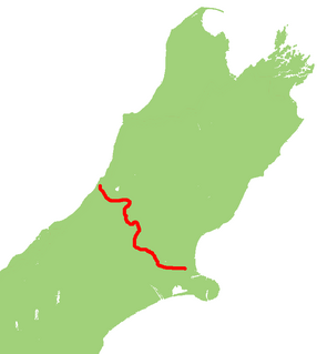
State Highway 44 (SH 44) is a New Zealand state highway. At 5.2 km it is one of the shortest highways on the network. Its entire length is within the New Plymouth city area.

New Zealand State Highway 73 road in New Zealand

State Highway 73 is a major east-west South Island state highway in New Zealand connecting Christchurch on the east coast with Cass/Hokitika via the Southern Alps. It is mostly two lane, with some single-lane bridges north of Springfield but is mostly dual carriageway in Christchurch. The fourth and fifth-highest points of New Zealand's state highway network are on this road at Porters Pass and Arthur's Pass respectively.

Provincial Highway 40 was part of the New Zealand state highway network before it was revoked in 1991-92.

Kaiapoi High School

Kaiapoi High School is a state co-educational secondary school located in Kaiapoi, in the Waimakariri District of New Zealand's South Island. The school serves 859 students from Years 9 to 13 as of August 2018.

Provincial (State) Highway 91 was part of the New Zealand state highway network before briefly becoming part of SH 92 in 1990–91. It ran for 13 kilometres through South Otago in the southern South Island. SH 92 itself had its status revoked a year later.

Papanui railway station

Papanui railway station served the suburb of Papanui in northern Christchurch, New Zealand. It was on the Main North Line between the stations of Bryndwr and Styx, 5.3 kilometres (3.3 mi) north of Addington Junction. The station handled freight and passenger traffic from when it opened in 1872 until closing in the late 20th century, and from 1880 was the site of an interchange between passenger rail and trams until the 1930s.

References

  1. "Transit New Zealand Traffic Volumes 1991" (PDF). Transit New Zealand. Retrieved 2 January 2012.
  2. "Transit New Zealand Traffic Volumes 1992" (PDF). Transit New Zealand. Retrieved 2 January 2012.
  3. "SH1/SH71 (Lineside Road) Interchange Upgrade" (PDF). Nzta.govt.nz.
  4. "Route of SH 71". Google Maps. Retrieved 2 January 2012.

Coordinates: 44°23′26″S171°15′04″E / 44.390540°S 171.251244°E / -44.390540; 171.251244

Geographic coordinate system Coordinate system

A geographic coordinate system is a coordinate system that enables every location on Earth to be specified by a set of numbers, letters or symbols. The coordinates are often chosen such that one of the numbers represents a vertical position and two or three of the numbers represent a horizontal position; alternatively, a geographic position may be expressed in a combined three-dimensional Cartesian vector. A common choice of coordinates is latitude, longitude and elevation. To specify a location on a plane requires a map projection.