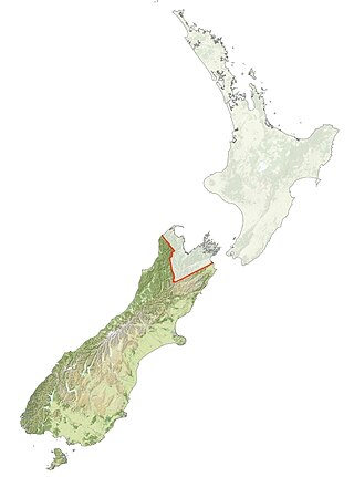
Ngāi Tahu, or Kāi Tahu, is the principal Māori iwi (tribe) of the South Island. Its takiwā is the largest in New Zealand, and extends from the White Bluffs / Te Parinui o Whiti, Mount Mahanga and Kahurangi Point in the north to Stewart Island / Rakiura in the south. The takiwā comprises 18 rūnanga corresponding to traditional settlements. According to the 2018 census an estimated 74,082 people affiliated with the Kāi Tahu iwi.

The Cook River / Weheka is in the South Island of New Zealand. The headwaters are from the La Perouse Glacier on the western flanks of the Southern Alps / Kā Tiritiri o te Moana, and it flows west, then northeast, then northwest and into the Tasman Sea. Its tributaries include the Balfour River, fed by Balfour Glacier, and the Fox River, fed by Fox Glacier / Te Moeka o Tuawe. Much of the river lies within the Westland Tai Poutini National Park. The river was renamed from Cook River to Cook River / Weheka as a result of the Ngāi Tahu Claims Settlement Act 1998.

Kaiapoi is a town in the Waimakariri District of the Canterbury region, in the South Island of New Zealand. The town is located approximately 17 kilometres north of central Christchurch, close to the mouth of the Waimakariri River. It is considered a satellite town of Christchurch and is part of the Christchurch functional urban area. The town is named after the nearby Kaiapoi Pā.
The Grey River / Māwheranui is located in the northwest of the South Island of New Zealand. It rises 12 kilometres southwest of the Lewis Pass in Lake Christabel, one of numerous small lakes on the western side of the Southern Alps, and runs westward for 120 kilometres before draining into the Tasman Sea at Greymouth. Thomas Brunner, who explored the area in the late 1840s, named the river in honour of Sir George Grey, who first served as Governor of New Zealand from 1845 to 1854. The Ngāi Tahu Claims Settlement Act 1998 changed the official name of the river to Grey River / Māwheranui in 1998. The Māori name for the river system and surrounding area is Māwhera, with Māwheranui being distinguished from the northern branch Little Grey River / Māwheraiti.

The Taramakau River is a river of the West Coast Region of the South Island of New Zealand. It rises in the Southern Alps / Kā Tiritiri o te Moana near Harper Pass, 80 kilometres (50 mi) due east of Hokitika, and runs westward for 75 kilometres (47 mi) into the Tasman Sea 15 kilometres (9.3 mi) south of Greymouth.

The Kaiapoi River is a minor river of north Canterbury, in New Zealand's South Island. Originally called the Cam River, it is a tributary of the Waimakariri River, which it joins at the larger river's estuary. The river is 16 kilometres (10 mi) long, and its drainage area is about 430 square kilometres (170 sq mi).

The Ashley River is in the Canterbury region of New Zealand. It flows generally southeastwards for 65 kilometres (40 mi) before entering the Pacific Ocean at Waikuku Beach, Pegasus Bay north of Christchurch. The town of Rangiora is close to the south bank of the Ashley River. The river's official name was changed from Ashley River to the dual name Ashley River / Rakahuri by the Ngāi Tahu Claims Settlement Act 1998.

Waimakariri District is a local government district, located in the Canterbury Region of New Zealand's South Island. It is named after the Waimakariri River, which forms the district's southern boundary, separating it from Christchurch City and the Selwyn District. It is bounded in the north by the Hurunui District and in the east by the Pacific Ocean.

Lake Ianthe is a lake located on the West Coast of New Zealand's South Island. A number of small streams flow into the lake and it empties into the Wanganui River. It is close to the coast and near the rural settlements of Pukekura and Hari Hari, and State Highway 6 runs along the eastern shore of the lake on its route between Ross and the Franz Josef Glacier.
The history of the Canterbury Region of the South Island of New Zealand dates back to settlement by Māori people in about the 14th century.

The Jacobs River or Makawhio River is located some 30 km (19 mi) south of Fox Glacier in South Westland, New Zealand. From its headwaters near Fettes Peak below the Hooker Range it flows in a westerly direction to enter the Tasman Sea near Hunts Beach. Its tributaries include Jumbo Creek and Pavo Creek. Just upstream from the bridge is Borat Flat.
Henare Whakatau Uru was a New Zealand politician. He was the Reform Party Member of Parliament for Southern Maori from 1922 to 1928.

The Cust River is a river in the Canterbury region of New Zealand. It flows east across the upper Canterbury Plains from its source north of the town of Oxford, New Zealand, flowing into the Cam River / Ruataniwha close to the town of Rangiora. The small town of Cust lies on the banks of the river. The lower part of the river, to the south-west of Rangiora, is diverted into a channel and called the "Main Drain". The channel was built in 1862 to drain the swampy land between Rangiora and the Waimakariri River, and when it was enlarged in 1868 it accidentally captured the Cust.

The Avon River / Ōtākaro flows through the centre of the city of Christchurch, New Zealand, and out to an estuary, which it shares with the Ōpāwaho / Heathcote River, the Avon Heathcote Estuary / Ihutai.

The Estuary of the Heathcote and Avon Rivers / Ihutai is the largest semi-enclosed shallow estuary in Canterbury and remains one of New Zealand's most important coastal wetlands. It is well known as an internationally important habitat for migratory birds, and it is an important recreational playground and educational resource. It was once highly valued for mahinga kai.
Mount Grey is a 934-metre (3,065 ft) mountain 15 kilometres west of Amberley in New Zealand. It is named after Sir George Grey who was governor of New Zealand when English surveyors climbed it in 1849. In Te Reo Māori, the mountain is called Maukatere, 'floating mountain', from where the spirits of the dead leave on the long journey to Cape Reinga.

The Ashburton River / Hakatere is a river in the Canterbury region of New Zealand, flowing across Mid Canterbury from the Southern Alps to the Pacific Ocean. The official name of the river was amended to become a dual name by the Ngāi Tahu Claims Settlement Act 1998. It has been identified as an Important Bird Area by BirdLife International because it supports breeding colonies of the endangered black-billed gull.

Kemp's Deed, also known as the Canterbury Purchase, Kemp's Purchase, or the Ngāi Tahu Purchase, is the purchase of Canterbury, New Zealand, from some Ngāi Tahu chiefs by Tacy Kemp on behalf of the New Zealand Company. It is the Crown's largest purchase from Ngāi Tahu and the "least carefully transacted". The grievance caused by the Crown was settled 150 years later through the Ngāi Tahu Claims Settlement Act 1998 and a compensation package valued at NZ$170 million.

Coopers Lagoon / Muriwai is a small coastal waituna-type lagoon in the Canterbury region of New Zealand, located approximately halfway between the mouth of the Rakaia River and the outlet of the much larger Lake Ellesmere / Te Waihora. While the present-day lagoon is separated from the nearby Canterbury Bight by approximately 100 metres (330 ft), the water of the lagoon is considered brackish and early survey maps show that, until recently, the lagoon was connected to the ocean by a small channel. The lagoon, along with the surrounding wetlands, has historically been an important mahinga kai for local Māori.
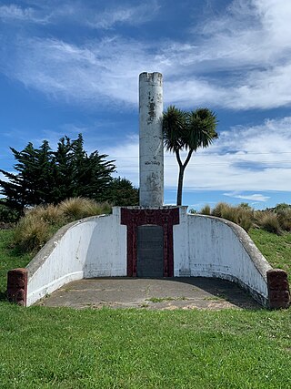
Kaiapoi Pā is a historic pā site just north of the Waimakariri River in Canterbury, New Zealand. The pā was a major centre of trade and nobility for Ngāi Tahu in the Classical Māori period.
