New Zealand State Highway 73

Last updated

State Highway 73 NZ.svg

State Highway 73
NZ-SH 73 map.png
Route information
Maintained by NZ Transport Agency
Length231 km (144 mi)
Tourist
routes
Great Alpine Highway
Christchurch Ring Road
Inland Scenic Route between Sheffield and Waddington.
Major junctions
Northwest end State Highway 6 State Highway 6 NZ.svg at Kumara Junction, New Zealand
Southeast end Curletts Road/Christchurch Southern Motorway State Highway 75 NZ.svg / State Highway 76 NZ.svg at Middleton, New Zealand
Location
Primary
destinations
Kumara, Dillmanstown, Jacksons, Otira, Arthur's Pass, Bealey, Cass, Castle Hill Village, Springfield, Sheffield, Waddington, Darfield, Kirwee, Aylesbury, West Melton, Yaldhurst, Christchurch
Highway system
State Highway 71 NZ.svg SH 71 SH 74 State Highway 74 NZ.svg

State Highway 73 (SH 73) is a major east-west South Island state highway in New Zealand connecting Christchurch on the east coast with Cass/Hokitika via the Southern Alps. It is mostly two lane, with some single-lane bridges north of Springfield but is mostly dual carriageway in Christchurch. The fourth and fifth-highest points of New Zealand's state highway network are on this road at Porters Pass and Arthur's Pass respectively.

South Island Southernmost of the two main islands in New Zealand

The South Island, also officially named Te Waipounamu, is the larger of the two major islands of New Zealand in surface area; the other being the smaller but more populous North Island. It is bordered to the north by Cook Strait, to the west by the Tasman Sea, and to the south and east by the Pacific Ocean. The South Island covers 150,437 square kilometres (58,084 sq mi), making it the world's 12th-largest island. It has a temperate climate.

The New Zealand state highway network is the major national highway network in New Zealand. Nearly 100 roads in the North and South Islands are state highways. All state highways are administered by the NZ Transport Agency.

Christchurch City in South Island, New Zealand

Christchurch is the largest city in the South Island of New Zealand and the seat of the Canterbury Region. The Christchurch urban area lies on the South Island's east coast, just north of Banks Peninsula. It is home to 404,500 residents, making it New Zealand's third-most populous city behind Auckland and Wellington. The Avon River flows through the centre of the city, with an urban park located along its banks.

Contents

History

The route connecting the West and East coasts of the South Island via the Southern Alps were known for hundreds of years by the Māori people, due to a flourishing pounamu trade. The Europeans were informed of the route by a local chief in the mid-19th century but was not used during his lifetime. In 1864, Arthur Dudley Dobson traversed from the east to the west coast from the Waimakariri River, thereby discovering Arthur's Pass. A route connecting Christchurch to Hokitika was fully completed in 1866, with the first Cobb & Co coach began operating that same year for the burgeoning gold rush.

Māori people Indigenous Polynesian people of New Zealand

The Māori are the indigenous Polynesian people of New Zealand. Māori originated with settlers from eastern Polynesia, who arrived in New Zealand in several waves of canoe voyages some time between 1250 and 1300. Over several centuries in isolation, the Polynesian settlers developed a unique culture, with their own language, a rich mythology, and distinctive crafts and performing arts. Early Māori formed tribal groups based on eastern Polynesian social customs and organisation. Horticulture flourished using plants they introduced; later, a prominent warrior culture emerged.

Pounamu

Pounamu are several types of hard and durable stone found in southern New Zealand. They are highly valued by the Māori, and objects made from pounamu play an important role in Māori culture. Geologically, pounamu are usually nephrite jade, bowenite, or serpentinite, but the Māori classify pounamu by color and appearance.

Arthur Dudley Dobson New Zealand engineer

Sir Arthur Dudley Dobson was a pioneer surveyor, engineer and explorer. Born in London, he came to Lyttelton, New Zealand in 1850 on one of the First Four Ships. He is best known for taking the first party of Europeans over Arthur's Pass.

SH 73 through Arthur's Pass ArthursPass.jpg
SH 73 through Arthur's Pass

Construction of a rail link had started in 1890, and the Midland Line between Canterbury and the West Coast was finally completed on 4 August 1923, with the opening of the Otira Tunnel. This signalled the end of the Cobb & Co coach in New Zealand. [1] When the section of the line from Springfield to Broken River in Canterbury was opened in 1906, it was then possible to travel from Canterbury to the West Coast in a single day with a 40-mile (64 km) coach journey between the railheads at Broken River and Otira.

Midland Line, New Zealand

The Midland line is a 212km section of railway between Rolleston and Greymouth in the South Island of New Zealand. The line features five major bridges, five viaducts and 17 tunnels, the longest of which is the Otira tunnel. It is the route of the popular TranzAlpine passenger train.

Otira Tunnel

The Otira Tunnel is a railway tunnel on the Midland Line in the South Island of New Zealand, between Otira and Arthur's Pass. It runs under the Southern Alps from Arthur's Pass to Otira – a length of over 8.5 kilometres (5.3 mi). The gradient is mainly 1 in 33, and the Otira end of the tunnel is over 250 m (820 ft) lower than the Arthur's Pass end.

Cobb & Co is the name of a company that operated a fleet of stagecoaches in Australia in the late 19th century. Cobb & Co themselves did not operate in New Zealand officially but their name was used by many private stage coach operators.

Due to the geography and topography between Springfield and Kumara, the road has been subjected to several closures and road realignments, with both Porters and Arthur's Pass subjected to frequent closures during the winter months. The road between Arthur's Pass and Otira in particular was amongst the most dangerous in the country, due to the road located on scree slopes which frequently gave way. As a result, numerous studies were conducted into alternative options for fixing the road around Candy's Bend, Starvation Point and the Zig Zag. Construction of the Otira Viaduct and the protective roofs from slips began in 1997 and opened in 1999. [2]

Springfield, New Zealand Village in Canterbury, New Zealand

Springfield is a small town in the Selwyn District of Canterbury, in the South Island, of New Zealand. The Maori name for Springfield is Tawera. In 2001 it had a population of 219. At the foot of the Southern Alps, 65 kilometres (40 mi) west of Christchurch, it is the most westerly town of the central Canterbury Plains. Springfield has a long association with the Midland railway line.

Kumara, New Zealand Place in West Coast, New Zealand

Kumara is a town on the West Coast of the South Island of New Zealand. It is located 30 kilometres (19 mi) south of Greymouth, close to the western end of State Highway 73, which leads across Arthur's Pass to Christchurch. The Taramakau River flows past to the north.

Porters Pass mountain pass in the Canterbury region of New Zealand

Porters Pass is a mountain pass in the Canterbury region of New Zealand's South Island.

Route

Kumara Junction to Christchurch

As of May 2016, this is the current route of the highway. [3]

State Highway 73 begins 11 km south of Greymouth at Kumara Junction. The highway passes through undulating farmland, scrubland and forest as it passes through the settlements of Kumara and Dillmanstown. The road veers sharply to the left as it approaches the mountains to the front of the road. The road then hugs the Taramakau River as it proceeds down the valley. At Jacksons, the Midland Line crosses the river and begins to run parallel to the road. Just before Aickens at the confluence of the Taramakau and Otira Rivers, the road and rail line veers to the right and runs to the south before reaching Otira.

Greymouth Place in West Coast, New Zealand

Greymouth is the largest town in the West Coast region in the South Island of New Zealand, and the seat of the Grey District Council. The population of the whole Grey District is 13,550, which accounts for 42% of the West Coast's inhabitants. The Greymouth urban area had an estimated population of 9,700. The District Council expects growth of 1.5% per year between 2006 and 2016.

Taramakau River river in New Zealand

The Taramakau River is in the northwest of the South Island of New Zealand. It rises in the Southern Alps, 80 kilometres due east of Hokitika, and immediately below the saddle of the Harper's Pass, and runs westward for 75 kilometres into the Tasman Sea 15 kilometres south of Greymouth.

Jacksons, New Zealand Place in New Zealand

Jacksons is a settlement and railway station in the Westland District of the West Coast of New Zealand. The TranzAlpine Express passes through Jacksons.

The Otira Viaduct Arthur's Pass.jpg
The Otira Viaduct

Beyond Otira, the road breaks with the railway line and crosses the river before climbing up towards the Otira Viaduct and Arthur's Pass. At 920 metres, Arthur's Pass is the second highest pass on the road and is one of the three alpine passes connecting the east and west coasts. After peaking, the road descends into Arthur's Pass village with the railway line emerging from the Otira Tunnel nearby.

After the village, the road and rail line runs along the Bealey River valley and crosses the Waimakariri River before veering left and running parallel to both the river and the rail line on the opposite side. Before Cass, the road runs along a bluff and turns right to proceed past some more farmland as well as Lakes Grasmere and Pearson.

Castle Hill Village Castle Hill Village Stevage.jpg
Castle Hill Village

The road then climbs up towards Castle Hill Village and runs through a valley before passing beside Lake Lyndon where it curves left before climbing up towards Porters Pass which, at 939 metres, is the highest point on the road. After cresting, the road descends into the Kowai River valley and runs roughly parallel with the river until it reaches Springfield.

The former Springfield doughnut with Mount Torlesse in the background Donut-springfield-nz.png
The former Springfield doughnut with Mount Torlesse in the background

After Springfield, the road emerges onto the Canterbury Plains and runs straight through the settlements of Annat, Sheffield and Waddington before arriving at Darfield. The road then passes through the settlements of Kirwee, Aylesbury and West Melton as well as dairy and lifestyle farms characteristic of the plains. The road passes by Paparua Prison and arrives in Christchurch via Yaldhurst. [4]

Christchurch

As Yaldhurst Road, the proceeds in an easterly direction towards Riccarton. The road widens to four lanes at Avonhead, but by Curletts Road/Peer Street, the highway turns right (while Yaldhurst Road becomes Riccarton Road and heads towards the city centre).

As Curletts Road, the road temporarily reverts to two lanes divided by a flush median. After Blenheim Road, however the road widens again, crosses over the Main South Line and eventually terminates at the Christchurch Southern Motorway (SH 76).

Route changes

Over the past 40 years SH 73 has been subjected to several route changes both in the Christchurch and the Arthur's Pass-Otira areas. In the early years SH 73 originally ended at the Blenheim Road and Hansons Lane corner in Upper Riccarton. In 1999, one of the worst sections of highway in the country (around Candy's Bend) were replaced with the Otira Viaduct. Meanwhile, in Christchurch, since SH 1 was rerouted to bypass the CBD, SH 73 was extended to Brougham Street/Waltham Road intersection, with the rest of the route covered by SH 74.

In 2004, with SH 74 being rerouted to run along the Ring Road and the entire length of Tunnel Road instead of through the CBD, SH 73 was extended further to the Port Hills Road interchange on SH 74. It was also rerouted from the intersection of Blenheim Road to follow Curletts Road and Yaldhurst Road, instead of via Main South Road through Hornby, meeting back again with SH 1 at the intersection of Masham and Russley Roads. [5]

As of December 2012, with the extension of the Christchurch Southern Motorway, the section of SH 73 east of Curletts Road was re-gazetted as SH 76 in line with the new motorway extension.

Former spur sections

State Highway 73A was a spur section of SH 73 connecting the suburbs of Hornby, New Zealand and Sockburn, New Zealand via Main South Road and Blenheim Road. Before 2004 it formed part of the old route of SH 73 and further before that SH 1. It was one of the few state highways in New Zealand to be wholly dual carriageway. In 2014, the entire highway has been revoked due to completion of the Christchurch Southern Motorway (gazetted SH 76 in 2012) which runs almost parallel to this route. [6]

Major junctions

Territorial authority LocationkmjctDestinationsNotes
Christchurch City Middelton0 New Zealand road sign W11-1.svg State Highway 75 NZ.svg SH 75 Akaroa
State Highway 76 NZ.svg SH 76 west (Christchurch Southern Motorway)Timaru
SH 73 begins
New Zealand road sign W11-1.svg State Highway 76 NZ.svg SH 76 east (Christchurch Southern Motorway)City Centre, Lyttelton
New Zealand road sign W10-4.svg (Lunns Road)
New Zealand road sign W10-4.svg (Parkhouse Road)
Upper Riccarton1 New Zealand road sign W10-4.svg (Blenheim Road) – Sockburn, Hornby, Riccarton, City Centre
New Zealand road sign W10-4.svg (Main South Road) – Sockburn, Church Corner
New Zealand road sign W10-4.svg (Peer Street) – Ilam
(Yaldhurst Road) – Riccarton, City Centre
New Zealand road sign W10-4.svg (Middlepark Road)
Avonhead New Zealand road sign W10-4.svg (Avonhead Road)
Russley5 New Zealand road sign W10-4.svg State Highway 1 NZ.svg SH 1 south – Hornby, Timaru
State Highway 1 NZ.svgAirport Sign.svg SH 1 northBelfast, Picton
Yaldhurst New Zealand road sign W10-4.svg (Sir John McKenzie Avenue)
New Zealand road sign W11-1.svg (Pound Road) – Templeton
New Zealand PW-11 (right).svg (Old West Coast Road) – Waddington
New Zealand PW-9.svg (Buchanans Road) – Hei Hei
West Melton15 New Zealand PW-9.svg (Chattertons Road/Dawsons Road)
Selwyn District
New Zealand PW-9.svg (Weedons Ross Road) – Rolleston, Timaru ( State Highway 1 NZ.svg )
(West Melton Road)
Aylesbury New Zealand PW-9.svg (Bealey Road/Aylesbury Road) – Burnham
(Station Road)
Kirwee New Zealand PW-57 (right).svg Midland Line
Darfield New Zealand PW-11 (left).svg (Bray Street) – Rakaia, Timaru ( State Highway 1 NZ.svg )
41 New Zealand PW-11 (left).svg State Highway 77 NZ.svg SH 77 (Bangor Road)Mount Hutt, Methven, Ashburton
Waddington New Zealand PW-11 (left).svg Regional Route 72 NZ.png Inland Scenic Route (Deans Road) – Mount Hutt, Methven, Ashburton
52 New Zealand PW-11 (right).svg Regional Route 72 NZ.png Inland Scenic Route (Waimakariri Gorge Road) – Oxford, Rangiora, Amberley
Springfield 68 New Zealand road sign R2-7.svg Kowai River – Bridge #1
Porters Pass81 Porters Pass (939 m (3,081 ft))
90 New Zealand road sign R2-7.svg Porter River
Castle Hill Village New Zealand PW-11 (left).svg (Castle Hill Drive) – Castle Hill Village
Cass New Zealand PW-11 (right).svg (Mount White Road)
Bealey131 New Zealand road sign R2-7.svg Broad Stream
133 New Zealand road sign R2-7.svg Bruce Stream
136 New Zealand road sign R2-7.svg Waimakariri River – Bealey Bridge
Arthur's Pass 145 New Zealand road sign R2-7.svg Rough Creek
151 Arthur's Pass (920 m (3,020 ft))
Westland District
Otira 153 New Zealand PW-44.svg Otira Viaduct
156 New Zealand road sign R2-7.svg Otira River – Yorkeys Point Bridge
159 New Zealand road sign R2-7.svg Otira River
165 New Zealand road sign R2-7.svg Kellys Creek
165 New Zealand PW-57 (left).svg Midland Line
Jacksons New Zealand PW-57 (right).svg Midland Line
174 New Zealand road sign R2-7.svg Rocky Creek Bridge
New Zealand PW-11 (right).svg (Lake Brunner Road) – Moana, Stillwater, Greymouth via Lake Brunner
Turiwhate191 New Zealand road sign R2-7.svg Taipo River
197 New Zealand road sign R2-7.svg Big Waihinihini River Bridge
Kumara Junction226 New Zealand PW-57 (left).svg
New Zealand road sign W11-1.svg
Hokitika Line
State Highway 6 NZ.svg SH 6 southHokitika, Haast, New Zealand
State Highway 6 NZ.svg SH 6 north Greymouth, Westport
Rail line bisects roundabout
SH 73 ends

See also

Related Research Articles

Arthurs Pass (mountain pass) mountain pass in New Zealand

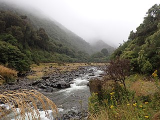
Arthur's Pass, a mountain pass in the Southern Alps of the South Island of New Zealand, marks part of the boundary between the West Coast and Canterbury regions. Located 140 km from Christchurch and 95 km from Greymouth, the pass comprises part of a saddle between the valleys of the Otira River and of the Bealey River. Arthur's Pass lies on the border of the Selwyn and Westland districts.

New Zealand State Highway 1 road in New Zealand

State Highway 1 is the longest and most significant road in the New Zealand road network, running the length of both main islands. It appears on road maps as SH 1 and on road signs as a white number 1 on a red shield, but it has the official designations SH 1N in the North Island, SH 1S in the South Island.

Main North Line, New Zealand railway line that runs north from Christchurch in New Zealand

The Main North Line, sometimes referred to as part of the South Island Main Trunk Railway, is a railway line that runs north from Christchurch in New Zealand up the east coast of the South Island through Kaikoura and Blenheim to Picton. It is a major link in New Zealand's national rail network and offers a connection with roll-on roll-off ferries from Picton to Wellington. It was also the longest railway construction project in New Zealand's history, with the first stages built in the 1870s and not completed until 1945.

New Zealand State Highway 7 road in New Zealand

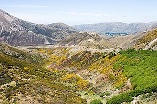
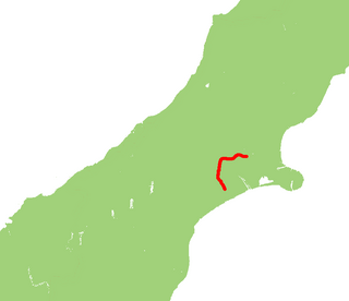
State Highway 7 is a major New Zealand state highway. One of the eight national highways, it crosses the Southern Alps to link the West Coast Region with Canterbury and to form a link between the South Island's two longest highways, State Highway 1 and State Highway 6. Distances are measured from east to west with the major junction list going from east to west.

The Christchurch Southern Motorway is a motorway to the south-west of Christchurch, New Zealand linking the inner-city suburb of Addington to the southern suburb of Hornby. The motorway, which is approximately 7.5 km long and is four-lane divided, forms part of State Highway 76.

State Highway 71 is a New Zealand state highway connecting Kaiapoi/Christchurch with Rangiora.

Arthurs Pass Township in Canterbury, New Zealand

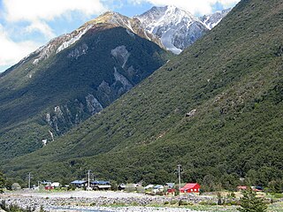
Arthur's Pass, previously called Camping Flat then Bealey Flats, and for some time officially Arthurs Pass, is a township in the Southern Alps of the South Island of New Zealand, located in the Selwyn district. It is a popular base for exploring Arthur's Pass National Park.

New Zealand State Highway 75 road in New Zealand

State Highway 75 (SH 75) is a state highway in New Zealand servicing the Banks Peninsula region, connecting Christchurch on the northwestern part of the peninsula with Akaroa towards the east coast. It is wholly two lane, but partially functions as a major arterial corridor of Christchurch. Its highest point is at Hilltop, where it rises to about 555 m - just 8 m lower than the more mountainous Haast Pass in the Southern Alps.

State Highway 74 is a state highway in New Zealand servicing the eastern suburbs of Christchurch. Mostly two-lane, it is composed of limited-access expressways, with part of the highway as the Christchurch-Lyttelton Motorway, and connects the city to its port town of Lyttelton.

Edwin Blake New Zealand politician

Edwin Blake was a 19th-century Liberal Party Member of Parliament in Canterbury, New Zealand.

New Zealand State Highway 77 road in New Zealand

State Highway 77 is a state highway in New Zealand going through the inland parts of Central and Mid Canterbury between the towns of Ashburton and Darfield via the Rakaia Gorge. It is wholly single carriageway with two one-lane bridges at the Rakaia and Selwyn Rivers. One set of traffic lights is found in Ashburton marking the southern terminus of the highway.

Mount Rolleston mountain in Arthurs Pass National Park

Mount Rolleston (2,271 m) is a prominent peak in Arthur's Pass National Park in the South Island of New Zealand. It was named by the surveyor Arthur Dudley Dobson in 1864, who observed the peak while searching for a route through the Southern Alps to the West Coast gold fields. The name honours the then Superintendent of the Canterbury Province, William Rolleston.

State Highway 79 (SH 79) is a New Zealand state highway connecting the South Canterbury communities of Rangitata, Geraldine, and Fairlie. Starting at State Highway 1 the highway is 61 kilometres in length and runs in a general east-west direction. 6.3 km of the highway through Geraldine runs concurrently with the Inland Scenic Route, formerly State Highway 72. The road is a two-lane single carriageway, with a one-lane bridge crossing the Orari River.

State Highway 76 (SH 76) is a state highway in Christchurch, New Zealand. This highway was gazetted in 2012 after stage 1 of the Christchurch Southern Motorway was completed. Beforehand, much of SH 76 was part of SH 73 and included the former two-lane Christchurch Arterial Motorway, which was upgraded to four lanes. SH 76 includes the entire length of the Christchurch Southern Motorway and forms the most direct route from the south of Christchurch to the city centre and Lyttelton.

The Western Corridor is a road in Christchurch, New Zealand which connects the suburb of Belfast, New Zealand in the north to Hornby in the south and connects the Canterbury region to Christchurch Airport. Most of the traffic on the corridor heads to the city, the airport, Belfast or Hornby, while 15% of traffic travels further north or south.

Sockburn, New Zealand Suburb

Sockburn is an industrial suburb of Christchurch, New Zealand, located between Hornby and Riccarton, some 7 kilometres (4.3 mi) west of the Christchurch city centre. The suburb is roughly bounded by the triangle formed by State Highway 1 in the west, Main South Road (SH73a) in the south and SH73 in the north. The suburb of Wigram, containing the city's former RNZAF base is located nearby. One of the city's main horseracing circuits, Riccarton Racecourse, is located close to Sockburn's northern edge, and Racecourse was the initial name for the area. The name Sockburn is likely to have come from the village of Sockburn in County Durham, England.

References