
Alexandra is a town in the Central Otago district of the South Island of New Zealand. It is located on the banks of the Clutha River, on State Highway 8, 188 kilometres (117 mi) by road from Dunedin and 33 kilometres (21 mi) south of Cromwell.
Central Otago is located in the inland part of the Otago region in the South Island of New Zealand. The motto for the area is "A World of Difference".

The Maniototo Plain, usually simply known as The Maniototo, is an elevated inland region in Otago, New Zealand. The region roughly surrounds the upper reaches of the Taieri River and the Manuherikia River. It is bounded by the Kakanui Range to the north and the Rock and Pillar Range to the southeast. It has a harsh, dry climate, ranging from over 30 °C in mid-summer to -15 °C in mid-winter.

Ranfurly is a town in the Central Otago District of Otago, New Zealand. Located 110 kilometres north of Dunedin, it lies in the dry rough plain of Maniototo at a moderately high altitude close to a small tributary of the Taieri River. It operates as a service town for the local farming community. The town was formerly known as Eweburn, one of the "farmyard" names bestowed by former Otago Chief Surveyor John Turnbull Thomson on many small streams and locations in the district. The modern name honours the Fifth Earl of Ranfurly, who served as Governor of New Zealand (1897–1904) at the time of the extension of the Otago Central Railway to the area. Ranfurly is well known for its Art Deco buildings, such as its hotel and the milk bar.
The town of Palmerston, in New Zealand's South Island, lies 50 kilometres to the north of the city of Dunedin. It is the largest town in the Waihemo Ward of the Waitaki District, with a population of 890 residents. Palmerston grew at a major road junction: State Highway 1 links Dunedin and Waikouaiti to the south with Oamaru and Christchurch to the north, while State Highway 85 heads inland to become the principal highway of the Maniototo. The Main South Line railway passes through the town and the Seasider tourist train travels from Dunedin to Palmerston and back once or twice a week. From 1880 until 1989, the town acted as the junction between the main line and a branch line that ran inland, the Dunback and Makareao Branches.
Strath Taieri is a large glacial valley and river plateau in New Zealand's South Island. It is surrounded by the rugged hill ranges to the north and west of Otago Harbour. Since 1989 it has been part of the city of Dunedin. The small town of Middlemarch is located at its southern end.
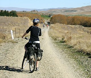
The Otago Central Rail Trail is a 150-kilometre walking, cycling and horse riding track in the South Island of New Zealand. A pioneering project for New Zealand, the successful rail trail joined the New Zealand Cycle Trail umbrella organisation in 2012, having been one of the inspirations for it.

Danseys Pass is a mountain pass located in the Kakanui Mountains, between Central Otago and North Otago, in the South Island of New Zealand.
John Turnbull Thomson was a British civil engineer and artist who played an instrumental role in the development of the early infrastructure of nineteenth-century Singapore and New Zealand.
The Dunback and Makareao Branches were two connected branch line railways, part of New Zealand's national rail network. Located in the Otago region of the South Island, both lines were 15km in length and shared the first 11km. The Dunback Branch, also known as the Waihemo Branch, opened in 1885 and closed in 1968; the Makareao Branch, also known as the Inch Valley Railway or the Inch Valley Branch, opened in 1900 and operated for 89 years to 1989.
Waipiata is an historic place on the Otago Central Rail Trail, in Central Otago, New Zealand. Waipiata is also the name of many New Zealand coastal vessels, steamers, freighters and steamships.
The township of Oturehua is in the Ida Valley of the Maniototo, in Central Otago, in the South Island of New Zealand.

State Highway 8 is one of New Zealand's eight national highways. It forms an anticlockwise loop through the southern scenic regions of the Mackenzie Basin and Central Otago, starting and terminating in junctions with State Highway 1. Distances are measured from north to south.

State Highway 57 is a New Zealand state highway, linking State Highway 1 north of Ohau to State Highway 3 east of Ashhurst, via Levin, Shannon, Massey University and the southern suburbs of Palmerston North. The highway connects State Highway 1 traffic coming north from Wellington to the city of Palmerston North, and further to the Manawatu Gorge, allowing passage to the eastern side of the North Island and to the twin cities of Napier and Hastings. The highway is classified by the NZTA as a national strategic road.

State Highway 87 is a state highway in New Zealand servicing the Taieri Plains and the Strath-Taieri Valley in Otago, connecting Mosgiel to Kyeburn on the eastern flank of the Maniototo Plains.
Waiwera South is a small settlement in the South Island of New Zealand, close to the boundary between the Otago and Southland regions. The settlement is located between Balclutha and Clinton, immediately to the south of State Highway 1, between branches of the Waiwera River and Kaihiku Stream, two minor tributaries of the Clutha River. The South Island Main Trunk railway also runs through the township. The settlement's population is around 100.
Morrisons is a small township in the Otago Region of New Zealand's South Island. It is located in the Maniototo, on State Highway 85 between Dunback and Ranfurly, some 45 kilometres southwest of Oamaru.
Lauder is a small settlement in the Otago Region of the South Island of New Zealand. It is located in Central Otago, 8 km northeast of Omakau, on the main route between Alexandra and Ranfurly, State Highway 85. The settlement was named after the town of the same name in southern Scotland, one of many Otago sites to be named after places in the Scottish borders by John Turnbull Thomson.
Kyeburn is a small settlement in Otago, in the South Island of New Zealand. It lies on the Maniototo, a wide, high plain stretching from the end of the Strath-Taieri valley.

