Maniototo

Last updated

Looking southwest across the Maniototo towards Rough Ridge from near Ranfurly Maniototo.jpg
Looking southwest across the Maniototo towards Rough Ridge from near Ranfurly
The Kakanui Range dominates the eastern horizon of the Maniototo Maniototoevening.jpg
The Kakanui Range dominates the eastern horizon of the Maniototo

The Maniototo Plain, usually simply known as The Maniototo, is an elevated inland region in Otago, New Zealand. [1] The region roughly surrounds the upper reaches of the Taieri River and the Manuherikia River. It is bounded by the Kakanui Range to the north and the Rock and Pillar Range to the southeast. It has a harsh, dry climate, ranging from over 30 °C in mid-summer to -15 °C in mid-winter.

Contents

The region is sparsely populated, with the largest centres being Ranfurly, Naseby, Wedderburn and Oturehua.

Part of the Canterbury-Otago tussock grasslands the land surrounding the plain is hilly, with many outcrops of rock which also break up the plain in places.

During the 1860s the region was one of the sites of the Central Otago goldrush, and relics from that era can still be seen around the towns of Kyeburn, Naseby, and St. Bathans.

Sheep farming is the major source of income. The area is closely associated with the sport of curling. Naseby has the only indoor curling rink and the only natural luge track in the Southern Hemisphere.

Demographics

The Maniototo statistical area covers 2,370.97 km2 (915.44 sq mi) [2] and had an estimated population of 1,810 as of June 2023, [3] with a population density of 0.8 people per km2.

Historical population
YearPop.±% p.a.
20061,566    
20131,554−0.11%
20181,635+1.02%
Source: [4]

Maniototo had a population of 1,635 at the 2018 New Zealand census, an increase of 81 people (5.2%) since the 2013 census, and an increase of 69 people (4.4%) since the 2006 census. There were 693 households, comprising 837 males and 798 females, giving a sex ratio of 1.05 males per female. The median age was 48.2 years (compared with 37.4 years nationally), with 279 people (17.1%) aged under 15 years, 228 (13.9%) aged 15 to 29, 726 (44.4%) aged 30 to 64, and 399 (24.4%) aged 65 or older.

Ethnicities were 90.8% European/Pākehā, 9.5% Māori, 0.7% Pasifika, 5.0% Asian, and 1.1% other ethnicities. People may identify with more than one ethnicity.

The percentage of people born overseas was 11.9, compared with 27.1% nationally.

Although some people chose not to answer the census's question about religious affiliation, 42.0% had no religion, 49.5% were Christian, 0.2% had Māori religious beliefs, 0.2% were Hindu and 0.9% had other religions.

Of those at least 15 years old, 177 (13.1%) people had a bachelor's or higher degree, and 327 (24.1%) people had no formal qualifications. The median income was $29,100, compared with $31,800 nationally. 150 people (11.1%) earned over $70,000 compared to 17.2% nationally. The employment status of those at least 15 was that 678 (50.0%) people were employed full-time, 225 (16.6%) were part-time, and 18 (1.3%) were unemployed. [4]

Maniototo County Council

Maniototo County Council existed between June 1877 and October 1989, when it became part of the Central Otago District Council. It was larger than the statistical area, at 1,239 sq mi (3,210 km2) and included the ridings of Mount Ida (Naseby), Hyde, St Bathans, Serpentine, Kyeburn, Puketoi and Idaburn. [5] The county offices were moved from Naseby to Ranfurly in 1936. [6]

Name

The original Māori name for the area is Māniatoto, [7] "plains of blood", which either referred to the red tussock that covers the landscape [7] or to old battles. [8] [9]

Early Pākehā settlers knew the area as Napiers Plain after Peter Napier, who purchased a run there in the 1850s. [10]

"Maniatoto" was the official name adopted by the Honorary Geographic Board of New Zealand in 1928, but the county council preferred "Maniototo", possibly because it had already installed a large sign with that spelling. [11]

While the New Zealand Geographic Board reaffirmed the Maniatoto spelling in 1948, it changed the official name to Maniototo in 1954 due to "long and accepted usage". [10]

Environment

Tussock landscape of the Oteake Conservation Park from the side of the Maniototo Oteake conservation park.jpg
Tussock landscape of the Oteake Conservation Park from the side of the Maniototo

The Maniototo plains are home to an array of native New Zealand wildlife and plants. The Otekake Conservation Park managed by the New Zealand Department of Conservation can be found at the northern end of the plains.

The Upper Taieri River flows through the Maniototo plains and is one of the only scroll plains in the Southern Hemisphere. The scroll plain works its way across the Maniototo and once flowed into an oxbow lake near the township of Kokonga. The lake was drained through agricultural practices. Today, there is much work underway through an initiative called Tiaki Maniototo the local community, farmers and business to restore the scroll plain and enrich the biodiversity that can be found here. [12]

The Maniototo is home to native species of New Zealand freshwater fish known as Galaxias. Rare Roundhead Galaxias (Galaxias anomalus) and Flathead Galaxias (Galaxias depressiceps) can be found in many creeks, streams and rivers across the plains and there is much work underway to protect their habitats from damage and introduced species such as trout. Some rare species of Galaxias are only found on the Maniototo.

In the novel Living in the Maniototo by Janet Frame, the region acts as a metaphor for the 'bloody plain' of the human imagination.

The scenery between Omakau and Ranfurly appeared in Peter Jackson's The Lord of the Rings film trilogy as the location for many of the scenes set in Rohan.

The cast and crew of the Jane Campion film The Power of the Dog which stars Benedict Cumberbatch stayed in Naseby while filming in the Ida Valley in the Maniototo. [13]

See also

Related Research Articles

<span class="mw-page-title-main">Otago</span> Region of New Zealand

Otago is a region of New Zealand located in the southern half of the South Island administered by the Otago Regional Council. It has an area of approximately 32,000 square kilometres (12,000 sq mi), making it the country's second largest local government region. Its population was 254,600 in June 2023.

<span class="mw-page-title-main">Middlemarch, New Zealand</span> Human settlement in Dunedin City, Otago Region, New Zealand

Middlemarch is a small town in the Otago region of New Zealand's South Island. It lies at the foot of the Rock and Pillar Range of hills in the broad Strath-Taieri valley, through which flows the middle reaches of the Taieri River. Since local government reorganisation in the late 1980s, Middlemarch and much of the Strath-Taieri has been administered as part of Dunedin city, the centre of which lies some 80 km to the southeast. Middlemarch is part of the Taieri electorate, and is currently represented in parliament by Ingrid Leary. Middlemarch has reticulated sewerage but no reticulated water supply. A description of 1903, that "[T]he summer seasons are warm, but not enervating, and the winters cold, but dry" is still true today.

<span class="mw-page-title-main">Dunedin</span> City in Otago, New Zealand

Dunedin is the second-largest city in the South Island of New Zealand, and the principal city of the Otago region. Its name comes from Dùn Èideann, the Scottish Gaelic name for Edinburgh, the capital of Scotland. The city has a rich Māori, Scottish, and Chinese heritage.

<span class="mw-page-title-main">Mosgiel</span> Town in Otago, New Zealand

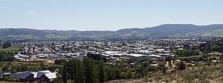
Mosgiel is an urban satellite of Dunedin in Otago, New Zealand, fifteen kilometres west of the city's centre. Since the re-organisation of New Zealand local government in 1989 it has been inside the Dunedin City Council area. Mosgiel has a population of approximately 14,800 as of June 2023. A nickname for Mosgiel is "The pearl of the plain". Its low-lying nature does pose problems, making it prone to flooding after heavy rains. Mosgiel takes its name from Mossgiel Farm, Ayrshire, the farm of the poet Robert Burns, the uncle of the co-founder in 1848 of the Otago settlement, the Reverend Thomas Burns.

<span class="mw-page-title-main">Naseby, New Zealand</span> Town in the South Island of New Zealand

Naseby is a small town, formerly a borough, in the Maniototo area of Central Otago, New Zealand. It is named after a village in Northamptonshire, England. Previous names of the township were Parker's, Hogburn and Mt Ida. The town catch phrase is "2000 feet above worry level" indicating its altitude. Naseby is 395 km from Christchurch and 143 km from Dunedin.

Central Otago is an area located in the inland part of the Otago region in the South Island of New Zealand. The motto for the area is "A World of Difference".

<span class="mw-page-title-main">Taieri River</span> River in New Zealand

The Taieri River is the fourth-longest river in New Zealand and is in Otago in the South Island. Rising in the Lammerlaw Range, it initially flows north, then east around the Rock and Pillar range before turning southeast, reaching the sea 30 kilometres (19 mi) south of Dunedin.

<span class="mw-page-title-main">Ranfurly, New Zealand</span> Settlement in Otago, New Zealand

Ranfurly is a town in the Central Otago District of Otago, New Zealand. Located 110 kilometres north of Dunedin, it lies in the dry rough plain of Maniototo at a moderately high altitude close to a small tributary of the Taieri River. It operates as a service town for the local farming community. The town was formerly known as Eweburn, one of the "farmyard" names bestowed by former Otago Chief Surveyor John Turnbull Thomson on many small streams and locations in the district. The modern name honours the Fifth Earl of Ranfurly, who served as Governor of New Zealand (1897–1904) at the time of the extension of the Otago Central Railway to the area. Ranfurly is well known for its Art Deco buildings, such as its hotel and the milk bar.

<span class="mw-page-title-main">Strath Taieri</span> Geographic region in New Zealand

The Strath Taieri is a large glacial valley and river plateau in New Zealand's South Island. It is surrounded by the rugged hill ranges to the north and west of Otago Harbour. Since 1989 it has been part of the city of Dunedin. The small town of Middlemarch is located at its southern end.

<span class="mw-page-title-main">Wedderburn, New Zealand</span> Locality in New Zealand

Wedderburn is a community in Central Otago, New Zealand. It is located 15 kilometres northwest of Ranfurly, and was at one time close to the centre of a thriving gold and coal mining area. The name of Wedderburn was given to the area by John Turnbull Thomson, and is one of the names in his infamous "Thomson's Barnyard", wedder being Northumbrian dialect form of the word wether, meaning a castrated sheep.

<span class="mw-page-title-main">Danseys Pass</span>

Danseys Pass is a mountain pass located in the Kakanui Range in the South Island of New Zealand.

Waipiata is an historic place on the Otago Central Rail Trail, in Central Otago, New Zealand. Waipiata is also the name of many New Zealand coastal vessels, steamers, freighters and steamships.

Mount Ida is a former parliamentary electorate in the Otago region of New Zealand, from 1871 to 1893, and then from 1902 to 1908.

<span class="mw-page-title-main">State Highway 85 (New Zealand)</span> Road in New Zealand

State Highway 85 (SH 85) is a South Island state highway in New Zealand, servicing the Maniototo Plains and the North and Central Otago regions of the South Island between the major settlements of Alexandra and Palmerston. It is wholly two lane and passes through some of the most extreme climatic regions in New Zealand. The highway is known colloquially as "The Pigroot". Though there is no definitive explanation for this name, A. W. Reed, in his book Place Names of New Zealand, mentions an incident during John Turnbull Thomson's survey of inland Otago in which local wild pigs were so unafraid of humans that a huge boar approached his party and rubbed its nose against that of Thomson's horse.

<span class="mw-page-title-main">State Highway 87 (New Zealand)</span> Road in New Zealand

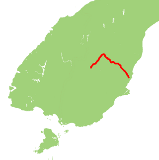
State Highway 87 (SH 87) is a state highway in New Zealand servicing the Taieri Plains and the Strath-Taieri Valley in Otago, connecting Mosgiel to Kyeburn on the eastern flank of the Maniototo Plains.

Kyeburn is a small settlement in Otago, in the South Island of New Zealand. It lies on the Maniototo, a wide, high plain stretching from the end of the Strath-Taieri valley.

Lake Manuherikia was a prehistoric lake which once stretched over some 5,600 square kilometres (2,200 sq mi) in what is now inland Otago in New Zealand's South Island. It stretched from Bannockburn and the Nevis valley in the west to Naseby in the east, and from the Waitaki valley in the north to Ranfurly in the south, including much of the area now referred to as the Maniototo. The lake existed from around 19 to 16 million years ago during the Miocene epoch, at which point New Zealand was significantly warmer than the present.

<span class="mw-page-title-main">Oteake Conservation Park</span>

Oteake Conservation Park is a protected area in the Waitaki District and Otago Region of New Zealand's South Island. Oteake or place of the ake is named by Kai Tahu iwi for the ake ake, a shrub daisy found throughout the park.

References

  1. "Place name detail: Maniototo Plain". New Zealand Gazetteer. New Zealand Geographic Board . Retrieved 18 June 2022.
  2. "ArcGIS Web Application". statsnz.maps.arcgis.com. Retrieved 31 October 2023.
  3. "Population estimate tables - NZ.Stat". Statistics New Zealand . Retrieved 25 October 2023.
  4. 1 2 "Statistical area 1 dataset for 2018 Census". Statistics New Zealand. March 2020. Maniototo (345700). 2018 Census place summary: Maniototo
  5. "Maniototo County Council - Central Otago District Council". www.codc.govt.nz. Retrieved 29 January 2022.
  6. "Otago Daily Times". paperspast.natlib.govt.nz. 15 August 1936. Retrieved 29 January 2022.
  7. 1 2 "Māniatoto". Kā Huru Manu. Nga Rūnanga o Ngāi Tahu. Retrieved 18 June 2022.
  8. Reed, A. W.; Dowling, Peter (2010). Place names of New Zealand (Rev. ed.). North Shore [City], N.Z.: Raupo. ISBN   9780143204107.
  9. "Place name detail: Maniatoto". New Zealand Gazetteer. New Zealand Geographic Board.
  10. 1 2 "Place name detail: Maniototo". New Zealand Gazetteer. New Zealand Geographic Board.
  11. "Council leaving official name change move to iwi". Otago Daily Times Online News. Otago Daily Times. 15 June 2022. Retrieved 18 June 2022.
  12. "Tiaki Maniototo | conservation". Tiaki Maniototo. Retrieved 29 March 2024.
  13. "When the movie stars came to town: a Central Otago family's farm was transformed for Jane Campion's The Power of the Dog". Stuff. 6 November 2021. Retrieved 13 November 2021.

45°09′13″S170°02′21″E / 45.1536°S 170.0392°E / -45.1536; 170.0392