Tāmaki Māori settled in the Orewa area since at least the 13th century, utilising the resources of the Ōrewa River and Whangaparāoa Bay, where an important shark fishery was located. After the Kawerau warrior Maki unified many of the Tāmaki Māori people of the northern and western Auckland Region, his younger son Maraeariki settled along the Ōrewa River. Kawerau hapū, including Ngāti Kahu, lived in the Orewa area until the mid-19th century.
Orewa was a part of the Mahurangi Block, forest sold to the Crown in 1841. Kauri loggers and itinerant kauri gum diggers were among the first Europeans to come to Orewa, with the first permanent residents arriving in the 1840s and 1850s. Orewa House was constructed in 1856, becoming the de Jersey Grut family home for three generations, later run as a boarding house and accommodation by Alice and Edward Eaves. During the 1920s, Orewa became a popular destination for campers and holidayers.
Orewa rapidly developed suburban housing in the 1950s and 1960s, in part due to the opening of the Auckland Harbour Bridge, with the town centre and Hillary Square developing from 1953. Further major developments at Orewa occurred in the 1980s and 2000s, and Orewa became the administrative centre for the Rodney District from 1989 to 2010. The town gained national press in 2004 when National Party leader Don Brash gave the Orewa Speech, in which he discussed race relations between Māori and Pākehā.
Geography
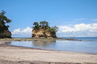
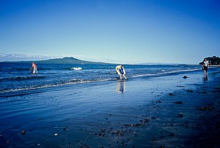
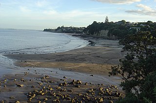
Ōrewa Beach, a major beach of Whangaparāoa Bay, lines the east of the townshipAlice Eaves Scenic Reserve features remnant kauri forests, including one tree estimated to be over 300 years old, and is also the location of Nukuhau, a Kawerau defensive pā
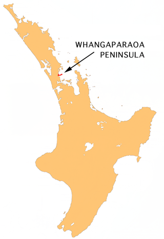
Orewa is a coastal town on the Hibiscus Coast, located on the northern shores of the Ōrewa River.[4][5] Ōrewa Beach lines the eastern margin of the settlement,[6] which is one of the major beaches surrounding Whangaparāoa Bay.[7] The highest point in Orewa is an 134 metres (440ft) hill in the Nukumea Scenic Reserve, from which the Nukumea Stream flows.[8]
Prior to human settlement, Orewa was primarily a kauri-dominated forest. By the 1840s, the Orewa beach was primarily sandhills, and likely had areas of peat swamp.[12]Alice Eaves Scenic Reserve is an area of Orewa that includes remnant kauri forest, including one estimated to be over 300 years old.[13]
Etymology
The settlement of Orewa takes its name from the adjacent Ōrewa River
The name Orewa was originally used to describe the Ōrewa River and estuary, and was later applied to the beach during European times.[12] The etymology of Ōrewa is unknown, but the most likely origin is that it is a shortening of Te Wai-o-Rewa ("The Waters of Rewa"), referring to an early Kawerau rangatira called Rewa.[4] References to the Ōrewa River in English date from at least the 1840s,[14]
Māori history
The Hibiscus Coast area has been settled since at least the 13th century, with many of the first Māori occupants identifying as Ngā Oho.[15] The wider area between the Ōrewa River and Mahurangi River was traditionally known as Mahurangi, named after a pā located at the mouth of the Waiwera River.[16] The Ōrewa River estuary features some of the most densely found archaeological sites in the area, and was an important sheltered harbour, which offered marine resources such as shellfish and flounder, and connections to inland walking routes.[15]Portages, where waka could be hauled overland between waterways, connected the Hibiscus Coast area to the Kaipara Harbour in the west. The Aotoetoe portage travelled north between the Kaukapakapa River and the Ōrewa River.[17][12]
Likely in the 17th century, the warrior Maki migrated from the Kāwhia Harbour to his ancestral home in the Auckland Region. Maki conquered and unified many of the Tāmaki Māori tribes as Te Kawerau ā Maki, including those of the North Shore and Hibiscus Coast.[18][19] After Maki's death, his sons settled different areas of his lands, creating new hapū, including the wider Hibiscus Coast hapū of Ngāti Manuhiri, Ngāti Maraeariki, Ngāti Poataniwha and Ngāti Kahu.[20][21]
Maki's younger son Maraeariki primarily settled at the head of the Ōrewa River.[20][22][23] An island in the Ōrewa River adjacent to his kāinga, Te Motu-o-Marae-Ariki, was named in remembrance of him.[24] His hapū Ngāti Maraeariki grew to occupy lands between Whangaparāoa and Ōmaha, while continuing to focus settlement at Orewa.[21] By the mid-1700s, Marutūāhu tribes from the Hauraki Gulf, especially Ngāti Pāoa, sought to control the Whangaparāoa Bay shark fishery, and waged war against Ngāti Kahu, a hapū formed from Maki's granddaughter Kahu, who were primarily based on the Whangaparāoa Peninsula.[25] During this period, Kawerau-descended hapū held exclusive land rights to the Hibiscus Coast area, while fishing rights were shared between Ngāti Kahu and Marutūāhu tribes.[21]
Orewa is home to two known defensive pā sites: Nukuhau Pā at Alice Eaves Scenic Reserve above the Nukumea Stream,[26][27] which was held by Kawerau-descendant hapū.[12] The second is Orewa South Bridge Pa, at the southern mouth of the Orewa estuary.[28] Traditional names recorded for the area include Nukumea, the stream to the north of Orewa, Wahakataka, the northern tributary of the Ōrewa River at Arran Hills and Te Rua Taniwha, at the western end of the Orewa estuary.[14] Te Rua Taniwha is associated with Ngāti Whātua o Kaipara ancestor Pokopoko-whiti-te-ra, who was famed for having slain a taniwha here.[29][30][31]
In September 1821 during the Musket Wars, a Ngāpuhi taua (war party) ventured south to avenge past losses against Ngāti Kahu in the 1790s. The Kawerau-descendant tribes were heavily defeated, and survivors fled to the Waikato, gradually returning in the 1830s.[32][25] On return, Ngāti Kahu formed intertribal marriages with Ngāti Whātua o Kaipara, seasonally migrating between Orewa, Te Haruhi Bay and Ōkura.[32][25] Naval officer Byron Drury recorded a settlement at the mouth of the Ōrewa River in 1853 called Poaheke, where the residents had been influenced by Wesleyan missionaries.[33] Ngāti Kahu settlement at Whangaparāoa continued until the 1870s.[25]
Early colonial era and holidaymakers
The de Grut family house at Orewa, pictured between 1880 and 1899. The house would later become a popular hotel, the Orewa House
Early kauri timber merchants were drawn to the Weiti River catchment to the south of Orewa by the late 1830s,[34] The Ōrewa River catchment was used during the 1840s and 1850s to a lesser extent.[33] Due to the former kauri forest, the Orewa area was a location that drew kauri gum diggers,[12] who harvested the area until the early 20th century.[35]
Following the signing of the Treaty of Waitangi in 1840,[36]the Crown made the first purchases of the Mahurangi and Omaha blocks on 13 April 1841, which included Orewa. While some iwi and hapū with customary interests had been engaged, such as Ngāti Paoa and Ngāi Tai ki Tāmaki, others, including Te Kawerau ā Maki, Ngāti Manuhiri and Ngāti Rango, were not involved with transactions.[37][38][39] This led to Ngāti Manuhiri being alienated from land on the Hibiscus Coast.[20]
The earliest permanent European resident in Orewa is likely sawyer and boatbuilder John Ryan, who bought land in 1854 but had lived in the area since the 1840s.[12] In the early 1850s, the Brunton family purchased land adjacent to the Orewa waterfall, establishing a home and jetty. The Brunton family constructed a bridge in 1880, and their house was home to the Orewa Falls post office.[12]
In 1856, Captain Isaac Rhodes Cooper built Orewa House with the 58th (Rutlandshire) Regiment of Foot.[40][12] This became the family residence of Channel Islands migrants, the de Jersey Gruts, in 1868,[40] after the family struggled to establish a farm at Birkenhead.[41] Orewa House was the de Jersey Grut home for three generations,[40] becoming a commercial guest house in 1906.[40] By the late 1880s, the clay road to Auckland was diverted to Wainui, leading the de Grut family to cut a road to Waiwera themselves.[40]
In the latter 19th century as kauri gum deposits became rarer, land at Orewa was developed into orchards, where apples, pears, grapes and citrus fruit were grown for the Auckland market. Gradually the orchards were replaced by dairy farms in the 1920s, when fruit growing became economic.[42]
In 1918, Francis Hitchins purchased the de Grut farm, selling Orewa House to Alice and Edward Eaves in 1919. Hitchins attempted to subdivide the farm, but land sales were disappointing, so onsold the farm to Dr. E. B. Gunson in the mid-1920s.[12] Orewa became a popular destination for campers and holidayers in the 1920s,[43] which led to the height of popularity of Orewa House.[12] By the 1930s, coastal steamers were no longer the major form of transportation due to improved roading infrastructure,[44] and in the 1940s Orewa Hall was constructed, where films were shown to the community.[45]
Suburban development
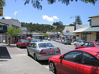
Shops in Orewa town centre, with the Nautilus apartment building in the backgroundOrewa Market
Orewa was subdivided for suburban housing in the 1950s.[12] The Orewa town centre was developed in 1953, which included a shopping precinct and Hillary Square.[46] The square is named after Sir Edmund Hillary, whose family owned a holiday bach at Orewa, where he stayed in summers in the 1930s.[47] This period saw the establishment of the Orewa Surf Life Saving Club in 1950,[48] and the Orewa Bowling Club in 1952.[49] In 1957, the Orewa Skating Rink was constructed. The rink developed into an entertainment precinct for the Hibiscus Coast in the 1960s, including a minigolf range and concert space. The rink was demolished in 1983.[50]
Orewa experienced a building and population boom in the 1960s, due to the opening of the Auckland Harbour Bridge,[51] rapidly urbanising between 1964 and 1975.[52] In 1966, Alice Eaves Scenic Reserve was established on the former lands adjacent to Orewa House, after the Eaves family donated the land to the Waitemata County Council after Alice Eaves' death,[53] and in the same year the Orewa Picture Theatre was constructed adjacent to Hillary Square.[40]
In 1968, Alan Horobin opened Orewa Marineland, a home for rescue animals including chimpanzees, llamas, seals, dolphins and "Sid the Sea elephant". Marineland closed in 1978.[54] The Orewa Combined Business Association formed in 1970.[55] The Orewa Community Centre was constructed in 1972.[56] Development of the northern shores of the Ōrewa River began in 1983 with further developed in 1995.[57]
A 2.5 metres (8ft 2in) concrete statue by Marinus van Kooten of Sir Edmund Hillary was unveiled in Hillary Square in 1983. The statue degraded over time, and was replaced with a bronze statue by Chen Wei Ming in 1991.[47] In 1990, the Centrestage Theatre was developed in Orewa by the United Players.[56]
By the late 1990s, the Auckland Northern Motorway was extended to Orewa.[58] This created a major link for the area back to the city. In 2004, a 12-storey apartment complex called the Nautilus was completed at Orewa. The only high rise building on the Hibiscus Coast, it is home to over 300 people, and in 2009 faced issues for being a leaky building.[59]
Orewa made political headlines on 27 January 2004, when New Zealand National Party leader Don Brash, then the leader of the opposition in Parliament, gave what became known as the Orewa Speech in front of the local Rotary club on a theme of race relations in New Zealand and, in particular, the special status of Māori. He advocated 'one rule for all'.[60]
In 2008, Kensington Park, the former site of the Orewa Caravan Park, was developed into a new housing area.[61]
Demographics
Orewa covers 6.80km2 (2.63sqmi)[1] and had an estimated population of 12,330 as of June 2023,[2] with a population density of 1,813 people per km2.
Orewa had a population of 10,242 at the 2018 New Zealand census, an increase of 1,653 people (19.2%) since the 2013 census, and an increase of 2,871 people (38.9%) since the 2006 census. There were 4,389 households, comprising 4,599 males and 5,643 females, giving a sex ratio of 0.81 males per female, with 1,287 people (12.6%) aged under 15 years, 1,170 (11.4%) aged 15 to 29, 3,720 (36.3%) aged 30 to 64, and 4,062 (39.7%) aged 65 or older.
Ethnicities were 86.1% European/Pākehā, 6.1% Māori, 2.7% Pacific peoples, 11.0% Asian, and 1.9% other ethnicities. People may identify with more than one ethnicity.
The percentage of people born overseas was 35.8, compared with 27.1% nationally.
Although some people chose not to answer the census's question about religious affiliation, 42.2% had no religion, 47.6% were Christian, 0.1% had Māori religious beliefs, 1.5% were Hindu, 0.5% were Muslim, 0.8% were Buddhist and 1.3% had other religions.
Of those at least 15 years old, 1,707 (19.1%) people had a bachelor's or higher degree, and 1,683 (18.8%) people had no formal qualifications. 1,530 people (17.1%) earned over $70,000 compared to 17.2% nationally. The employment status of those at least 15 was that 3,210 (35.8%) people were employed full-time, 1,107 (12.4%) were part-time, and 165 (1.8%) were unemployed.[62]
Orewa District High School was founded in 1956. In 1974, the school was split into Orewa School and Orewa College. Orewa Beach School was founded in 1978 (originally as Orewa North School), and another primary school opened at Red Beach to the south in 1988.[66]
Orewa College is a secondary (years 7–13) school with a roll of 2087 students.[67]
Orewa School and Orewa Beach School are contributing primary (years 1–6) schools, with rolls of 417 students[68] and 433 students[69] respectively.
All three schools are coeducational. Rolls are as of August 2024.[70]
Local government
From 1877 until 1974, Orewa was administered by the Waitemata County, a large rural county north and west of the city of Auckland.[23] In 1974 the county was dissolved,[71] becoming part of Rodney County, them from 1989 to 2010 Rodney District. Orewa was the administrative centre for the Rodney District.[72] The Rodney District was amalgamated into Auckland Council in November 2010, under a single unitary authority system.[73]
Within the Auckland Council, Orewa is a part of the Hibiscus Coast subdivision of the Hibiscus and Bays local government area, governed by the Hibiscus and Bays Local Board.[74] It is a part of the Albany ward, which elects two councillors to the Auckland Council.
Related Research Articles
The North Shore is one of the major geographical regions of Auckland, the largest city in New Zealand. The area is defined as the northern shores of the Waitematā Harbour as far north as the Ōkura River.
Warkworth is a town on the Northland Peninsula in the upper North Island of New Zealand. It is in the northern part of the Auckland Region. It is located on State Highway 1, 64 km (40 mi) north of Auckland and 98 km (61 mi) south of Whangārei, and is at the head of Mahurangi Harbour.
East Coast Bays is a string of small suburbs that form the northernmost part of the North Shore, part of the contiguous Auckland metropolitan area in New Zealand. The suburbs line the north-east coast of the city along the shore of the Hauraki Gulf and Rangitoto Channel. They include, from north to south, Long Bay, Torbay, Waiake Bay, Browns Bay, Rothesay Bay, Murrays Bay, Mairangi Bay, Campbells Bay and Castor Bay. Most of the East Coast Bays are covered under the East Coast Bays subdivision of the Hibiscus and Bays local board area.
The Whangaparāoa Peninsula is a suburban area about 30–50 km north of Auckland, New Zealand. It had 33,390 residents in 2018. It stretches from Red Beach, where it connects to Kingsway, Orewa and Silverdale, and extends to Army Bay in the Hauraki Gulf. It is part of the Hibiscus Coast. The area is populated by residents who work on the peninsula, or commute from the area to other parts of the Hibiscus Coast, the North Shore, Rodney district, Auckland CBD and beyond for work. They travel by vehicle, or via the Gulf Harbour ferry at Gulf Harbour Marina, or the Hibiscus Coast Bus Station at Silverdale. There is one main road along its entire length, which is accessible from State Highway 1 via Hibiscus Coast Highway at Silverdale, or from Hibiscus Coast Highway at Orewa via Red Beach. It is popular as a tourist destination for catching a ferry to Tiritiri Matangi Island, and for visiting Shakespear Regional Park. It has one open (Whangaparāoa Golf Club) and one closed golf club (Gulf Harbour Country Club), beaches, sporting and recreation facilities, a library, shops, businesses and public and private primary and secondary schools. The median age of the population is in the 30s-40s.
Browns Bay is one of the most northernmost suburbs in the contiguous Auckland metropolitan area, located in the North Shore. Named after the Brown family who settled here in 1876, Browns Bay became a holiday destination in the late 19th century. The area gradually developed into a suburb of Auckland in the 1950s, and was the administrative centre for the East Coast Bays City from 1975 until it was disestablished in 1989. During the 1990s, the suburb became a hub for the South African New Zealander community.
Mairangi Bay is a coastal suburb of North Shore, Auckland, located in the northern North Island of New Zealand, on the south-east-facing peninsula forming the northern side of the Waitematā Harbour. Mairangi Bay came under the local governance of the North Shore City Council until subsumed into the Auckland Council in 2010.
Torbay is a northern suburb of Auckland, New Zealand. It is located in the upper East Coast Bays of the city's North Shore, and is governed by Auckland Council.
The Hibiscus Coast is a populated area on a stretch of the Hauraki Gulf coast in New Zealand's Auckland Region. It has a population of 64,660, making it the 10th most populous urban area in New Zealand, and the second most populous in the Auckland Region, behind Auckland itself. As an urban area delineated by Statistics New Zealand, the Hibiscus Coast consists of Hatfields Beach, Orewa, Silverdale and Whangaparāoa Peninsula. The Auckland Council's Hibiscus Coast subdivision of the Hibiscus and Bays includes the neighbouring communities of Waiwera and Stillwater, and Milldale in Rodney, is also described as a part of the Hibiscus Coast.
Castor Bay is a bay and suburb of the North Shore, located in Auckland which is in the North Island of New Zealand. Located between Milford and Campbells Bay, it is part of the East Coast Bays. To the east lies the islands of Rangitoto and Motutapu, which are easily visible from land. The suburb is in the North Shore ward, one of the thirteen administrative divisions of Auckland Council.
Rothesay Bay is a small suburb in Auckland's East Coast Bays region. The suburb is roughly the same size as Murrays Bay, the suburb to the immediate south.
Murrays Bay is a small suburb in the East Coast Bays region, located in the North Shore of Auckland. The suburb is roughly the same size as Rothesay Bay, the suburb to the immediate north. It is primarily a residential area but does have a community centre, restaurant and café. Murrays Bay is regularly serviced by buses which go to Takapuna and the Auckland city centre.
Snells Beach is a small coastal town in the north of Auckland Region in the North Island of New Zealand. It is situated on the eastern coast of the Mahurangi Peninsula and its namesake beach faces east across Kawau Bay to Kawau Island. The nearest town is Warkworth, 8 km (5.0 mi) to the west, which is linked by 8 buses a day and also Mahu City Express twice a day.
Te Kawerau ā Maki, Te Kawerau a Maki, or Te Kawerau-a-Maki is a Māori iwi (tribe) of the Auckland Region of New Zealand. Predominantly based in West Auckland, it had 251 registered adult members as of June 2017. The iwi holds land for a new marae and papakāinga at Te Henga that was returned in 2018; and land for a secondary marae at Te Onekiritea that was returned in 2015. it has no wharenui yet.
Long Bay is one of the northernmost suburbs of the North Shore, part of the contiguous Auckland metropolitan area located in New Zealand.
Campbells Bay is a suburb of the North Shore located in Auckland, New Zealand.
The Puhoi River is a river of the Auckland Region of New Zealand's North Island. It flows southeast from its sources 10 kilometres (6 mi) southwest of Warkworth, passing through the town of Puhoi before reaching the coast of Whangaparaoa Bay seven kilometres north of Orewa.
Scandrett Regional Park is a regional park located on the north east tip of the Mahurangi Peninsula, north of the city of Auckland, New Zealand. It encompasses Mullet Point and includes regenerating coastal forest, rocky headlands that protrude into Kawau Bay, Scandretts Bay beach and a precinct of historic farm buildings. The people of Auckland own the park through the Auckland Council.
Waiake is one of the northernmost suburbs of the North Shore, in Auckland, New Zealand. It is located in the East Coast Bays between the suburbs of Browns Bay to the south and Torbay to the north. It has a beach, which looks out to the Tor, a presque-isle at the north end of the beach that becomes an island at high tide. Waiake is under the local governance of the Auckland Council.
Schnapper Rock is a western suburb on the North Shore of Auckland, New Zealand. The suburb is currently under local governance of Auckland Council. The area was known for a gum digging hut used by early European settlers in the mid-19th century. North Shore Memorial Park was opened area in 1974, and the area developed into suburban housing in the early 2000s.
Baddeleys Beach and Campbells Beach are a contiguous settlement on adjacent beaches on the southern side of Tāwharanui Peninsula in the Auckland Region of New Zealand. The beaches are on Millon Bay, which is a part of Kawau Bay.
↑ Rodney District Council. Alice Eaves Scenic Reserve Management Plan(PDF) (Report). Archived from the original(Approved by the Hibiscus Coast Area Committee on 17 September 1998 Amended by the Strategy and Community Committee on 6 March 2008) on 3 June 2010. Retrieved 7 January 2022.
↑ Murdoch, Graeme (1990). "Nga Tohu o Waitakere: the Maori Place Names of the Waitakere River Valley and its Environs; their Background History and an Explanation of their Meaning". In Northcote-Bade, James (ed.). West Auckland Remembers, Volume 1. West Auckland Historical Society. p.13-14. ISBN0-473-00983-8.
↑ Adam, Jack; Burgess, Vivien; Ellis, Dawn (2004). Rugged Determination: Historical Window on Swanson 1854-2004. Swanson Residents and Ratepayers Association Inc. pp.38–39. ISBN0-476-00544-2.
↑ "Rodney District". National Library of New Zealand. Retrieved 9 January 2024.
This page is based on this Wikipedia article Text is available under the CC BY-SA 4.0 license; additional terms may apply. Images, videos and audio are available under their respective licenses.