Stillwater, Auckland

Last updated

Stillwater
Yatches moored at Stillwater.jpg
Yachts moored at Stillwater
Stillwater, Auckland
Coordinates: 36°38′20″S174°42′54″E / 36.639°S 174.715°E / -36.639; 174.715
CountryNew Zealand
City Auckland
Local authority Auckland Council
Electoral ward Albany ward
Local board Hibiscus and Bays
Area
[1]
  Land44 ha (109 acres)
Population
 (June 2023) [2]
  Total1,030
Postcode(s)
0794, 0932, 0992
Wainui Silverdale Red Beach
Dairy Flat
Pfeil oben.svg
Pfeil links.svgStillwaterPfeil rechts.svg
Pfeil unten.svg
Stanmore Bay
Dairy Flat Ōkura Hauraki Gulf

Stillwater is a village in the northern end of Auckland in the North Island of New Zealand. [3] Situated on the Weiti River immediately south of the Whangaparaoa Peninsula in the Rodney District, it is part of the area known as the Hibiscus Coast. There is also a Stillwater, West Coast in the South Island.

Contents

History

In the 1850s, century Silverdale (then known as The Wade) was established as a port for transporting kauri logs to Auckland. [4] Stillwater was also used as a secondary landing to transport logs, kauri gum and later fruit produce from orchards established on cleared land at Stillwater, Silverdale and Dairy Flat. As there was no roading sea was the only form of transport available. The last shipment of kauri gum to leave Stillwater was in 1890. The pack horse tracks from Dairy Flat are still clearly visible on the Weiti Station property.[ citation needed ] The earliest European name for the area was Five Fingers, in reference to the many sandspits found along the Weiti River. [5]

The earliest settler in the Stillwater area was Ranulph Dacre, who began timber felling in 1848. [5] Dacre was followed by Andrew Weatherspoon Thorburn and his family in 1852. Part of his original holding is now a reserve and memorial park bequeathed on their farm.[ citation needed ] Several houses were built on the river's edge in the early days as more land was cleared and made available for farming. Some live stock was introduced, but fruit from orchards seemed to be the major produce transported to Auckland from Stillwater.[ citation needed ]

Other early settlers included the Percy, Blackshaw and McPike brothers families.[ citation needed ] In 1950 the McPike brothers subdivided their farm to form what has become the Stillwater settlement known today. After the Second World War the motor camp was developed and a road from East Coast Road constructed. Prior to this there existed only a farm track to Stillwater with a ford crossing at Doctor's Creek. The original bridge built was gradually improved over the years to the two lane concrete bridge today.[ citation needed ]

In 1958, a residential subdivision was constructed in the area, bringing more residents. This is the point when Stillwater was adopted as the name of the settlement. [5] In 1980 the Council began tar-sealing the road. In 1985 Stillwater was connected to the Whangaparaoa sewerage system and more substantial houses were built in the area. By the year 2000, most of the power and telephone cables were put underground and footpaths formed the length of Stillwater Crescent. Houses were built on almost all the original sections developed and Stillwater could no longer be called a holiday resort; it had become a well established marine suburb.[ citation needed ]

In time Coastal Heights was developed followed by the adjoining Inlet Views property and new coastal development is taking place over the river opposite the Stillwater Boat Club. Buildings continue to appear as land is cleared.[ citation needed ]

In late 2022, construction began on a new motorway between the Auckland Northern Motorway and the Whangaparāoa Peninsula, crossing the Weiti River at Stillwater and connecting the township to the Auckland motorways network. [6] The road is projected to open in 2026. [7]

Demographics

Statistics New Zealand describes Stillwater as a rural settlement, which covers 0.44 km2 (0.17 sq mi) [1] and had an estimated population of 1,030 as of June 2023, [2] with a population density of 2,341 people per km2. The settlement is part of the larger Silverdale South statistical area. [8]

Historical population
YearPop.±% p.a.
2006816    
2013867+0.87%
2018975+2.38%
Source: [9]

Stillwater had a population of 975 at the 2018 New Zealand census, an increase of 108 people (12.5%) since the 2013 census, and an increase of 159 people (19.5%) since the 2006 census. There were 345 households, comprising 513 males and 465 females, giving a sex ratio of 1.1 males per female, with 201 people (20.6%) aged under 15 years, 147 (15.1%) aged 15 to 29, 528 (54.2%) aged 30 to 64, and 96 (9.8%) aged 65 or older.

Ethnicities were 93.5% European/Pākehā, 8.3% Māori, 0.3% Pacific peoples, 4.6% Asian, and 1.2% other ethnicities. People may identify with more than one ethnicity.

Although some people chose not to answer the census's question about religious affiliation, 65.2% had no religion, 25.5% were Christian, 0.3% had Māori religious beliefs, 0.3% were Muslim and 2.2% had other religions.

Of those at least 15 years old, 168 (21.7%) people had a bachelor's or higher degree, and 78 (10.1%) people had no formal qualifications. 195 people (25.2%) earned over $70,000 compared to 17.2% nationally. The employment status of those at least 15 was that 492 (63.6%) people were employed full-time, 120 (15.5%) were part-time, and 12 (1.6%) were unemployed. [9]

Related Research Articles

<span class="mw-page-title-main">Auckland Region</span> Region of New Zealand

Auckland is one of the 16 regions of New Zealand, which takes its name from the eponymous urban area. The region encompasses the Auckland metropolitan area, smaller towns, rural areas, and the islands of the Hauraki Gulf. Containing 33 percent of the nation's residents, it has by far the largest population and economy of any region of New Zealand, but the second-smallest land area.

<span class="mw-page-title-main">Orewa</span> Suburb in Auckland, New Zealand

Orewa is a suburb of Auckland, New Zealand’s largest city. It lies on the Hibiscus Coast, just north of the base of the Whangaparāoa Peninsula and 40 kilometres north of central Auckland. It is a popular holiday destination.

Whangaparāoa Peninsula Suburban area in Auckland Council, Auckland, New Zealand

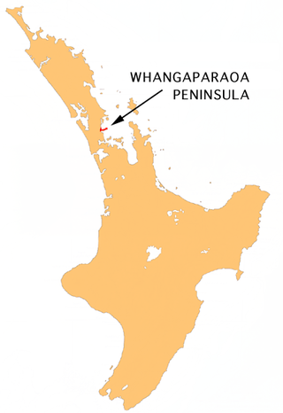
The Whangaparāoa Peninsula is a suburban area about 30–50 km north of Auckland, New Zealand. It had 33,390 residents in 2018. It stretches from Red Beach, where it connects to Kingsway, Orewa and Silverdale, and extends to Army Bay in the Hauraki Gulf. It is part of the Hibiscus Coast. The area is populated by residents who work on the peninsula, or commute from the area to other parts of the Hibiscus Coast, the North Shore, Rodney district, Auckland CBD and beyond for work. They travel by vehicle, or via the Gulf Harbour ferry at Gulf Harbour Marina, or the Hibiscus Coast Bus Station at Silverdale. There is one main road along its entire length, which is accessible from State Highway 1 via Hibiscus Coast Highway at Silverdale, or from Hibiscus Coast Highway at Orewa via Red Beach. It is popular as a tourist destination for catching a ferry to Tiritiri Matangi Island, and for visiting Shakespear Regional Park. It has one open (Whangaparāoa Golf Club) and one closed golf club (Gulf Harbour Country Club), beaches, sporting and recreation facilities, a library, shops, businesses and public and private primary and secondary schools. The median age of the population is in the 30s-40s.

<span class="mw-page-title-main">Hibiscus Coast</span> Stretch of the Hauraki Gulf

The Hibiscus Coast is a populated area on a stretch of the Hauraki Gulf coast in New Zealand's Auckland Region. It has a population of 63,400, making it the 10th most populous urban area in New Zealand, and the second most populous in the Auckland Region, behind Auckland itself.

<span class="mw-page-title-main">Whangateau</span> Place in Auckland Region, New Zealand

Whangateau is a small town on the east coast of the North Island of New Zealand. It is situated in Rodney District, part of the Auckland Region, and is on a peninsula stretching out into the Hauraki Gulf, north of Auckland. Whangateau is on the northern shore of Whangateau Harbour which is fed by the Ōmaha River and separated from Ōmaha Bay by the Maungatawhiri sandspit. The settlement is in two parts of 20 to 30 houses each. The main settlement includes a large public reserve with sports fields and a campground. There is also a public hall which hosts music events and a flax weaving group. The smaller settlement is Tram Car Bay, named for two tram cars which were used as holiday homes. Whangateau is situated between the rural settlement of Matakana and the fishing village of Leigh. A tsunami siren is located in the town.

<span class="mw-page-title-main">Silverdale, Auckland</span> Suburb in Auckland, New Zealand

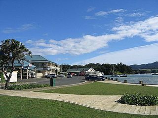
Silverdale is a village approximately 30 km north of Auckland in the North Island of New Zealand. It is located on the north bank of the Weiti River and lies to the west of the Whangaparaoa Peninsula.

O Mahurangi Penlink, is a future state highway that is expected to open in 2026. Once completed the new state highway will create a more direct and quicker route between the Whangaparaoa Peninsula and central Auckland in New Zealand.

Wainui is a locality in the Rodney Ward of the Auckland Region of New Zealand. It is 5 kilometres (3.1 mi) north-east of Waitoki and 10 kilometres (6.2 mi) west of Orewa. The Wainui Stream flows south-west through the area and into the Kaukapakapa River.

<span class="mw-page-title-main">Red Beach, New Zealand</span> Suburb in Auckland, New Zealand

Red Beach is a suburb surrounding the beach of the same name on the Hibiscus Coast, Auckland, New Zealand, at the base of the Whangaparaoa Peninsula. The suburb of Silverdale is to the south-west, and Orewa to the north.

<span class="mw-page-title-main">Stanmore Bay</span> Suburb in Auckland, New Zealand

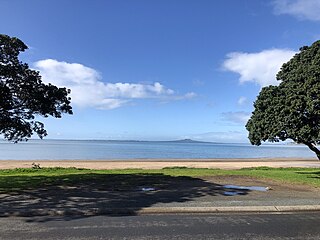
Stanmore Bay is a suburb and beach located on the Whangaparaoa Peninsula, in the Auckland Region of New Zealand. The beach is on the northern side of the peninsula.

<span class="mw-page-title-main">Port Albert, New Zealand</span> Place in Auckland Region, New Zealand

Port Albert is situated on the shores of the Kaipara Harbour, approximately 8 kilometres west of Wellsford, in the Auckland Region of New Zealand. Originally called Albertland, it was the last of the major organised British settlements in New Zealand.

<span class="mw-page-title-main">Rodney ward</span> Ward of Auckland in New Zealand

Rodney Ward is a local government area in the northernmost part of New Zealand's Auckland Region, created along with the Auckland Council in 2010. The area was previously part of Rodney District; it does not include the Hibiscus Coast, which was also part of Rodney District but is now in Albany ward. The Rodney Local Board area has the same boundaries as Rodney Ward.

<span class="mw-page-title-main">Albany ward (local government)</span> Ward of Auckland in New Zealand

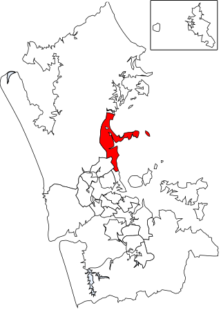
Albany Ward is an Auckland Council ward which elects two councillors and covers the Hibiscus and Bays and Upper Harbour Local Boards. The two councillors are currently John Watson and Wayne Walker.

<span class="mw-page-title-main">Hibiscus and Bays Local Board</span> Local board of Auckland Council in New Zealand

The Hibiscus and Bays Local Board is one of the 21 local boards of the Auckland Council. It is one of two boards overseen by the council's Albany Ward councillors. The board consists of eight members elected at large.

<span class="mw-page-title-main">Upper Harbour Local Board</span> Local board of Auckland Council in New Zealand

The Upper Harbour Local Board is one of the 21 local boards of the Auckland Council, and is one of the two boards overseen by the council's Albany Ward councillors.

<span class="mw-page-title-main">Mangōnui</span> Place in Northland Region, New Zealand

Mangōnui is a settlement on the west side of Mangōnui Harbour in Northland, New Zealand. State Highway 10 runs through it. It is the easternmost of the Taipa-Mangonui string of settlements, separated from Coopers Beach to the northwest by Mill Bay Road.

<span class="mw-page-title-main">Arkles Bay</span> Suburb in Auckland, New Zealand

Arkles Bay is one of the northernmost suburbs of the contiguous Auckland metropolitan area located in New Zealand. It is located on the southern side of the Whangaparaoa Peninsula, in the Hibiscus Coast, located 25 kilometres (16 mi) north of the Auckland CBD. It is part of the Albany Ward area for local government purposes. Arkles Bay is known for its sheltered beaches, suitable for swimming and paddle boarding.

<span class="mw-page-title-main">Baddeleys Beach-Campbells Beach</span> Place in Auckland Region, New Zealand

Baddeleys Beach and Campbells Beach are a contiguous settlement on adjacent beaches on the southern side of Tāwharanui Peninsula in the Auckland Region of New Zealand. The beaches are on Millon Bay, which is a part of Kawau Bay.

<span class="mw-page-title-main">Waiomu</span> Rural settlement in New Zealand

Waiomu is a settlement on the west coast of the Coromandel Peninsula of New Zealand, between Tapu to the north and Te Puru to the south. State Highway 25 runs through it.

<span class="mw-page-title-main">Karepiro Bay</span>

Karepiro Bay is a bay of the Hauraki Gulf / Tīkapa Moana in the Auckland Region, New Zealand. It found between the Whangaparāoa Peninsula and North Shore, and is the mouth of the Weiti River and Ōkura River.

References

  1. 1 2 "ArcGIS Web Application". statsnz.maps.arcgis.com. Retrieved 2 June 2022.
  2. 1 2 "Subnational population estimates (RC, SA2), by age and sex, at 30 June 1996-2023 (2023 boundaries)". Statistics New Zealand . Retrieved 25 October 2023. (regional councils); "Subnational population estimates (TA, SA2), by age and sex, at 30 June 1996-2023 (2023 boundaries)". Statistics New Zealand . Retrieved 25 October 2023. (territorial authorities); "Subnational population estimates (urban rural), by age and sex, at 30 June 1996-2023 (2023 boundaries)". Statistics New Zealand . Retrieved 25 October 2023. (urban areas)
  3. "My Auckland: Stillwater". New Zealand Herald. 1 July 2012.
  4. Grover 2008, pp. 8–16.
  5. 1 2 3 Grover 2008, pp. 54–55.
  6. "O Mahurangi Penlink - December 2022". createsend.com. Retrieved 21 December 2022.
  7. "Penlink: Frequently asked questions". NZTA. Retrieved 3 May 2022.
  8. 2018 Census place summary: Silverdale South (Auckland)
  9. 1 2 "Statistical area 1 dataset for 2018 Census". Statistics New Zealand. March 2020. 7001576–7001579 and 7001592–7001593.

Bibliography