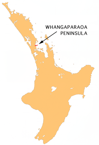
Manly is a suburb on the Whangaparaoa Peninsula, towards the northern end of Auckland, New Zealand.[3] Manly Village is an established shopping centre,[4] with the residential areas of Big Manly Beach to the north and Little Manly Beach to the south. The area was once a seaside holiday location, but has become residential suburbs within commuting distance of central Auckland city.
Initially inhabited primarily by Ngāti Kahu,[5] Manly is also home to two pā sites.[6][7] In 1851 it was brought by the Crown as part of the Mahurangi purchase.[8] By the 1890s, the land was settled by the Polkinghorne family.[9]
In the 1920s, Ted Brown and Laurie Taylor began development of the area, also constructing a pier off Little Manly Beach.[10] During this time the region was renamed after Manly a geographically similar seaside suburb north of Sydney.[11][12]
Around 1927 the Hopper Family moved into the area,[13] and farmed the area for a number of years. Later in the 1950s, the family then began subdividing the remaining land along with various other parts of the Hibiscus Coast.[14]
Demographics
Manly covers 2.61km2 (1.01sqmi)[1] and had an estimated population of 6,150 as of June 2023,[2] with a population density of 2,356 people per km2.
Manly had a population of 5,904 at the 2018 New Zealand census, an increase of 261 people (4.6%) since the 2013 census, and an increase of 651 people (12.4%) since the 2006 census. There were 2,238 households, comprising 2,829 males and 3,075 females, giving a sex ratio of 0.92 males per female, with 1,065 people (18.0%) aged under 15 years, 993 (16.8%) aged 15 to 29, 2,562 (43.4%) aged 30 to 64, and 1,284 (21.7%) aged 65 or older.
Ethnicities were 92.7% European/Pākehā, 9.5% Māori, 3.1% Pacific peoples, 3.8% Asian, and 1.5% other ethnicities. People may identify with more than one ethnicity.
The percentage of people born overseas was 26.2, compared with 27.1% nationally.
Although some people chose not to answer the census's question about religious affiliation, 55.8% had no religion, 33.6% were Christian, 0.3% had Māori religious beliefs, 0.4% were Hindu, 0.2% were Muslim, 0.9% were Buddhist and 1.9% had other religions.
Of those at least 15 years old, 1,005 (20.8%) people had a bachelor's or higher degree, and 720 (14.9%) people had no formal qualifications. 1,038 people (21.5%) earned over $70,000 compared to 17.2% nationally. The employment status of those at least 15 was that 2,280 (47.1%) people were employed full-time, 696 (14.4%) were part-time, and 165 (3.4%) were unemployed.[15]
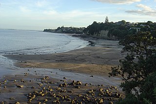
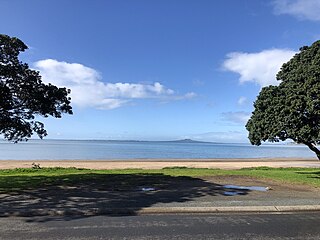
Manly is home to three Whangaparaoa Peninsula beaches, two on the northern and one on the southern side.[1] The largest and most notable is the soft, white, sandy, and popular swimming location Big Manly Beach. [18] The Beach stretches approximately 1.25 kilometres[1] and looks out over Whangaparāoa Bay. Over the summer months, a swimming pontoon is usually moored at Big Manly Beach. [19]
Big Manly is accompanied by Swann Beach, which sits to the west, together forming Polkinghornes Bay. [1]
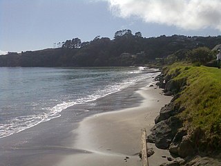
Little Manly, which is located on the southern side, is known for its calm and picturesque outlook and conditions.[20] At a length of around 300 metres[1] Little Manly is one of the peninsula's smaller beaches. In 2018, Little Manly also gained a swimming pontoon which is moored there over the summer. [19]
Education
Whangaparaoa School is a coeducational contributing primary (years 1-6) school with a roll of 692 students as of February 2024.[21][22] The school celebrated its centenary in 2002.[23]
Sport and Recreation
Sailing
The Manly Sailing Club[24] hosts a variety of Regional, National and International regattas off the coast of Big Manly Beach.[25] Formally established on 13April 1964(59 years ago)(1964-04-13)[26], the club also provides a variety of Learn to Sail Programmes through the Russell Coutts Sailing Foundation,[27] and has links to schools in the area.[28]
Bowling
Manly has been home to the Manly Bowling Club since it was incorporated on 13August 1956;67 years ago(1956-08-13)[29]. Each year the club hosts a number of bowling, and social events.[30]
Tennis
Manly is home to two tennis clubs, situated in both Edith Hopper Park and Manly Park.
The Whangaparaoa Tennis Club is the larger of the two and situated in Edith Hopper Park.[31] The tennis club was established in 1951;73years ago(1951)[32] in Manly Park, where the Manly Park Seniors Club is now located and later shifted to it current location in Edith Hopper Park in 1978. [33] The club provides six artificial flood-lit courts, and accompanying facilities, [34] offering courses for people of all ages and skill levels. [34]
Situated in Manly Park, alongside the bowling club, the Manly Park Seniors Tennis Club[35] has four courts as well as accompanying facilities. [36]
Netball
The Hibiscus Coast Netball Centre is home to six netball courts is located in Edith Hopper Park.[37] On 25 February 2021 the Hibiscus Coast Netball Centre voted in favour of Netball North Harbour taking over administration of the club.[38][39]
Orewa is a settlement in the northern Auckland Region of New Zealand. It is a suburb of the Hibiscus Coast, just north of the base of the Whangaparāoa Peninsula and 40 kilometres (25 mi) north of central Auckland. The Northern Motorway, part of State Highway 1, passes just inland of Orewa and extends through the twin Johnston Hill tunnels to near Puhoi.
Point Chevalier is a residential suburb and peninsula in the city of Auckland in the north of New Zealand. It is located five kilometres to the west of the city centre on the southern shore of the Waitematā Harbour. The suburb was originally a working-class area, with some state houses in the area, but over the past several decades the suburb has seen growth into becoming a middle-class suburb, with several redevelopment projects either completed or underway. Like most of the suburbs surrounding, Point Chevalier is known for its Californian style bungalows.
The Whangaparāoa Peninsula is a suburban area about 30–50 km north of Auckland, New Zealand. It had 33,390 residents in 2018. It stretches from Red Beach, where it connects to Kingsway, Orewa and Silverdale, and extends to Army Bay in the Hauraki Gulf. It is part of the Hibiscus Coast. The area is populated by residents who work on the peninsula, or commute from the area to other parts of the Hibiscus Coast, the North Shore, Rodney district, Auckland CBD and beyond for work. They travel by vehicle, or via the Gulf Harbour ferry at Gulf Harbour Marina, or the Hibiscus Coast Bus Station at Silverdale. There is one main road along its entire length, which is accessible from State Highway 1 via Hibiscus Coast Highway at Silverdale, or from Hibiscus Coast Highway at Orewa via Red Beach. It is popular as a tourist destination for catching a ferry to Tiritiri Matangi Island, and for visiting Shakespear Regional Park. It has one open (Whangaparāoa Golf Club) and one closed golf club (Gulf Harbour Country Club), beaches, sporting and recreation facilities, a library, shops, businesses and public and private primary and secondary schools. The median age of the population is in the 30s-40s.
Browns Bay is one of the most northernmost suburbs in the contiguous Auckland metropolitan area, located in the North Shore. Named after the Brown family who settled here in 1876, Browns Bay became a holiday destination in the late 19th century. The area gradually developed into a suburb of Auckland in the 1950s, and was the administrative centre for the East Coast Bays City from 1975 until it was disestablished in 1989. During the 1990s, the suburb became a hub for the South African New Zealander community.
The Hibiscus Coast is a populated area on a stretch of the Hauraki Gulf coast in New Zealand's Auckland Region. It has a population of 64,660, making it the 10th most populous urban area in New Zealand, and the second most populous in the Auckland Region, behind Auckland itself. As an urban area delineated by Statistics New Zealand, the Hibiscus Coast consists of Hatfields Beach, Orewa, Silverdale and Whangaparāoa Peninsula. The Auckland Council's Hibiscus Coast subdivision of the Hibiscus and Bays includes the neighbouring communities of Waiwera and Stillwater, and Milldale in Rodney, is also described as a part of the Hibiscus Coast.
Stillwater is a village in the northern end of Auckland in the North Island of New Zealand. Situated on the Weiti River immediately south of the Whangaparaoa Peninsula in the Rodney District, it is part of the area known as the Hibiscus Coast. There is also a Stillwater, West Coast in the South Island.
Whangaparāoa College is a co-educational state secondary school on the Hibiscus Coast of New Zealand. It was built on the same site as, and absorbed, Hibiscus Coast Intermediate School, with the only other state secondary school on the Hibiscus Coast being Orewa College. The decile 9 school serves Years 7 to 13. Opened officially in 2005, the founding principal was Brian O'Connell, who served until 2012. James Thomas took over the principal role in 2012. The current principal is Steve McCracken.
O Mahurangi Penlink, is a 7-kilometre-long (4.3-mile), two-lane future state highway. Construction began in late 2022 and is expected to conclude in late 2026. Once completed the new state highway will create a more direct and quicker route between the Whangaparaoa Peninsula and central Auckland in New Zealand.
Murrays Bay is a small suburb in the East Coast Bays region, located in the North Shore of Auckland. The suburb is roughly the same size as Rothesay Bay, the suburb to the immediate north. It is primarily a residential area but does have a community centre, restaurant and café. Murrays Bay is regularly serviced by buses which go to Takapuna and the Auckland city centre.
Red Beach is a suburb surrounding the beach of the same name on the Hibiscus Coast, Auckland, New Zealand, at the base of the Whangaparaoa Peninsula. The suburb of Silverdale is to the south-west, and Orewa to the north.
Stanmore Bay is a suburb and beach located on the Whangaparaoa Peninsula, in the Auckland Region of New Zealand. The beach is on the northern side of the peninsula.
Alan John Sayers was a New Zealand journalist, photographer and athlete who worked for The New Zealand Herald prior to World War II. When the war was over he was invited to join the Auckland Star where he was the first reporter in New Zealand to receive a personal by-line. In 1953 he was an official journalist on the tour of Queen Elizabeth II to the Pacific Islands and New Zealand.
Shakespear Regional Park is a nature park in the Auckland Region of New Zealand. It is located at the tip of the Whangaparaoa Peninsula, and is named after the Shakespear family which bought the land in the 1880s from local Maori.
State Highway 17 was the designation for a 32-kilometre stretch of highway in northern Auckland in the North Island of New Zealand from December 1999 to October 2012. It is now designated Urban Route 31 and consists of the Hibiscus Coast Highway, Dairy Flat Highway and Albany Expressway. It linked State Highway 1 at Puhoi in the north with SH 1 at Albany in the south. Its main destinations were the towns of Waiwera, Orewa, Red Beach, Whangaparaoa, Silverdale, Dairy Flat and the suburb of Albany. Prior to its inception as SH 17, the road was part of SH 1, and was redesignated as SH 17 as the Northern Motorway was extended northwards and took over the designation of SH 1.
John Watson is a New Zealand politician who is a councillor on the Auckland Council.
Waiake is one of the northernmost suburbs of the North Shore, in Auckland, New Zealand. It is located in the East Coast Bays between the suburbs of Browns Bay to the south and Torbay to the north. It has a beach, which looks out to the Tor, a presque-isle at the north end of the beach that becomes an island at high tide. Waiake is under the local governance of the Auckland Council.
The Hibiscus and Bays Local Board is one of the 21 local boards of the Auckland Council. It is one of two boards overseen by the council's Albany Ward councillors. The board consists of eight members elected at large.
Matakatia is a suburb situated on the Whangaparaoa Peninsula, towards the northern end of Auckland, New Zealand. It is about 43 kilometres north of the city centre.
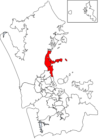
Hibiscus and Bays is a local government area in Auckland, in New Zealand's Auckland Region, governed by the Hibiscus and Bays Local Board and Auckland Council. It currently aligns with the council's Albany Ward.
Arkles Bay is one of the northernmost suburbs of the contiguous Auckland metropolitan area located in New Zealand. It is located on the southern side of the Whangaparaoa Peninsula, in the Hibiscus Coast, located 25 kilometres (16 mi) north of the Auckland CBD. It is part of the Albany Ward area for local government purposes. Arkles Bay is known for its sheltered beaches, suitable for swimming and paddle boarding.
This page is based on this Wikipedia article Text is available under the CC BY-SA 4.0 license; additional terms may apply. Images, videos and audio are available under their respective licenses.