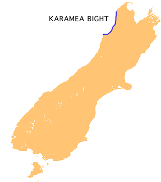
The Karamea Bight is the name given to a large bay in the Tasman Sea formed by a curved stretch of the West Coast of New Zealand's South Island. It stretches for 100 kilometres north from Cape Foulwind to just north of the mouth of the Heaphy River.
The Inangahua River is located in the north-west of New Zealand’s South Island. It is a major tributary of the Buller River, where it joins at the town of Inangahua Junction.
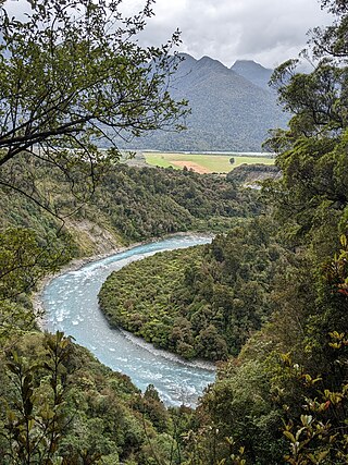
The Waimangaroa River is located on the West Coast of New Zealand.
The Papahaua Range is a mountain range on the West Coast of New Zealand's South Island east of the town of Westport. It is a geological continuation of the Paparoa Range that is south of the Buller River and it runs north from the Buller Gorge to the Mōkihinui River. At its north end, it meets the Glasgow Range.
Anama is a sparsely populated locality in the Canterbury region of New Zealand's South Island. It is on the Hinds River, with the Ashburton River / Hakatere not far to the north in nearby Mount Somers. Other nearby settlements include Valetta to the east, Mayfield to the south, and Montalto to the west. Anama School celebrated its centenary in March 2002.
Mid Canterbury is a traditional, semi-official subregion of New Zealand's Canterbury Region extending inland from the Pacific coast to the Southern Alps. It is one of four traditional sub-regions of Canterbury, along with South Canterbury, North Canterbury, and Christchurch City.
The Tauweru River, sometimes called the Taueru River, is a river in the Wairarapa region of New Zealand's North Island. It drains from the pastoral eastern highlands of the Wairarapa and joins the Ruamahanga River just north of the Gladstone Road bridge into Gladstone, southeast of Carterton. The river's name is Māori for "hanging in clusters" and named after it is the town of Tauweru, located along the middle reaches of the river east of Masterton.
Wheatstone is a locality in the Canterbury region of New Zealand's South Island. It is located on the Canterbury Plains south of Ashburton, on the banks of the Ashburton River / Hakatere. Other nearby settlements include Huntingdon to the north, Eiffelton and Flemington to the west, Ashton and Waterton to the south, and Riverside and Wakanui to the east on the opposite side of the Ashburton River / Hakatere. Wheatstone is slightly inland from the coastline of the Pacific Ocean.
Waterton is a former town in the Canterbury region of New Zealand's South Island. It is still officially recognised as a locality.
The Hodder River is a river of the northeastern South Island of New Zealand. It flows north from the northwestern slopes of Mount Tapuae-o-Uenuku, joining with the Awatere River 40 kilometres (25 mi) southwest of Seddon.
The Kaniere River is a river of New Zealand. It is located in the West Coast Region of the South Island. The river is the outflow of Lake Kaniere, and flows west to reach the Hokitika River five kilometres from the coast of the Tasman Sea.
The Little Hohonu River is a river of New Zealand's West Coast Region. It flows northwest from its origins in the Hohonu Range southwest of Lake Brunner, reaching the Greenstone River / Hokonui 20 kilometres southeast of Greymouth.
The Makikihi River is a river of the South Canterbury region of New Zealand's South Island. It flows east from its headwaters in the Hunters Hills 30 kilometres (19 mi) southwest of Timaru, and passes through the small township of Makikihi before reaching the Pacific Ocean.
The Morgan River is a river of the West Coast Region of New Zealand's South Island. It flows generally west from the small Lake Morgan, high in the Kaimata Range of the Southern Alps, reaching the Crooked River 18 kilometres (11 mi) from the latter's outflow into Lake Brunner.
The Porter River is a river of the Canterbury Region of New Zealand's South Island. It rises close to the southern end of the Craigieburn Range east of Lake Coleridge, flowing generally northeast to reach the Broken River close to Castle Hill. The Porters Ski Area is above the river valley's western flank, and State Highway 73 follows the river's course for some distance to the west of Porters Pass.
The Te Wharau or Stony River is a river of the West Coast Region of New Zealand's South Island. It flows generally east from its sources in the Paparoa Range to reach the Inangahua River 15 kilometres north of Reefton.
The Taipo River is a river of the central West Coast Region of New Zealand's South Island. It flows north from its sources west of Mount Rolleston, fed by the waters of several mountain streams. After some 15 kilometres it turns northeast to flow past the Bald Range before reaching the valley of the Taramakau River into which it flows 35 kilometres east of Hokitika.

Carters Beach is a suburb of Westport on the West Coast of New Zealand's South Island. Located 6 kilometres (4 mi) west of Westport on State Highway 67A, it offers a pristine sheltered sandy beach on the West Coast suitable for swimming. From the Buller River jetty at the east end of Carters Beach, west to Cape Foulwind, the beach runs for more than 9 uninterrupted kilometres.

The Blackwater River is located in the Buller District of New Zealand. It flows north-northwest for 19 kilometres (12 mi) from the northern slopes of Mount Copernicus in the Paparoa Range, reaching the Buller River 16 kilometres (9.9 mi) west of Inangahua in the lower Buller Gorge.
