
The Hutt River flows through the southern North Island of New Zealand. It flows south-west from the southern Tararua Range for 56 kilometres (35 mi), forming a number of fertile floodplains, including Kaitoke, central Upper Hutt and Lower Hutt.

The Wairarapa, a geographical region of New Zealand, lies in the south-eastern corner of the North Island, east of metropolitan Wellington and south-west of the Hawke's Bay Region. It is lightly populated, having several rural service towns, with Masterton being the largest. It is named after its largest lake, Lake Wairarapa.
Waipukurau is the largest town in the Central Hawke's Bay District on the east coast of the North Island of New Zealand. It is located on the banks of the Tukituki River, 7 kilometres south of Waipawa and 50 kilometres southwest of Hastings.

The Remutaka Range is the southernmost range of a mountain chain in the lower North Island of New Zealand. The chain continues north into the Tararua, then Ruahine Ranges, running parallel with the east coast between Wellington and East Cape.

The Tararua Range, often referred to as the Tararua Ranges or Tararua, is one of several mountain ranges in the North Island of New Zealand.
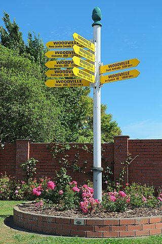
Woodville, previously known as The Junction, is a small town in the southern North Island of New Zealand, 75 km north of Masterton and 25 km east of Palmerston North. The 2013 census showed that 1401 people reside in Woodville.
Coonoor is a small sheep-farming district in the Northern Wairarapa, approximately 38 km south-east of Dannevirke, and 48 km north-east of Pahiatua. The name Coonoor was first used for one of the early sheep runs in the district, and later became the name of the district and small school. Coonoor is situated at the double junction of four roads. One goes straight to Dannevirke, crossing the boundary between Wellington and Hawkes Bay provinces. The second main route leads to Pahiatua via Makuri, which has always been a larger centre of population than Coonoor, and the locale of several social and sports clubs. The third road crosses the Puketoi Range to Horoeka, Waione, Pongaroa and the East Coast, while the fourth, known as the Makairo Track, is no longer open to vehicular traffic, and heads toward Woodville, between Dannevirke and Pahiatua. This narrow winding road is now a favourite route for mountain bikers.

"The bush" is a term mostly used in the English vernacular of South Africa, Australia, and New Zealand where it is largely synonymous with hinterland or backwoods respectively, referring to a natural undeveloped area. The fauna and flora contained within this area may be mostly indigenous to the region, although exotic species will often also be present.

The Napier Express was a passenger express train operated by the New Zealand Railways Department initially between Napier and Palmerston North and later between Napier and Wellington. It ran from 1891 until 1954.

Pūkaha National Wildlife Centre is a captive breeding facility and visitor centre located in a protected forest area on State Highway 2 in New Zealand's Tararua district. It was formerly called Mount Bruce National Wildlife Centre, then Pūkaha / Mount Bruce National Wildlife Centre.

State Highway 2 runs north–south through eastern parts of the North Island of New Zealand from the outskirts of Auckland to Wellington. It runs through Tauranga, Gisborne, Napier, Hastings and Masterton. It is the second-longest highway in the North Island, after State Highway 1, which runs the length of both of the country's main islands.
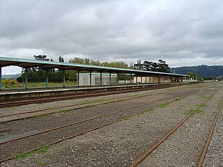
Woodville railway station is the northern terminus of the Wairarapa Line and is located at the junction with the Palmerston North–Gisborne Line in the small Tararua town of Woodville, 27 km (17 mi) east of Palmerston North in New Zealand's North Island.

Remutaka Forest Park is a protected area near Wellington, New Zealand. Popular access points are south of Wainuiomata and in the upper Hutt Valley. The park covers 220 square kilometres (85 sq mi), encompassing the Catchpool Valley and the Ōrongorongo Valley at the southern end of the Remutaka Range. Established in 1972, the park contains several short walks and six huts that can be booked and accessed by longer bush tramps. The park is one part of several local conservation areas, as it borders the Pakuratahi Forest and the Tararua Range.
Te Rehunga is a rural locality located in the Tararua District, part of the Manawatu Whanganui Region of New Zealand.
The National Provincial Championship, or NPC, was the predecessor to the current Air New Zealand Cup and Heartland Championship in New Zealand rugby. 1978 was the third year of the National Provincial Championship, Wellington were the winners of Division 1.
Wairarapa and Hawke's Bay is a former parliamentary electorate in the Wellington region of New Zealand from 1853 to 1859, when it was extended into previously unincorporated territories, split in two, and replaced by the County of Hawke, with its southern portion being the newly created Wairarapa electorate. It is the first general electorate to have been abolished in New Zealand.
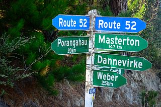
State Highway 52 is a former state highway now reclassified Route 52. It runs from Waipukurau, to Masterton in the Wairarapa through Porangahau on the east coast and the Weber and Pongaroa hill country in the Tararua District on the lower eastern side of the North Island.

Mnesarchaea hudsoni is a species of primitive moths in the family Mnesarchaeidae. This species was first described by George William Gibbs in 2019, and is endemic to New Zealand. It is found in the Auckland, Coromandel, Bay of Plenty, Taupo, Gisborne, Hawkes Bay, Wairarapa and Wellington regions. This species inhabits cool, damp parts of native forest or lives alongside waterways and can be found at altitudes ranging from sea-level up to 800 m. Adults of this species are on the wing from February to April. M. hudsoni is very similar in appearance to its near relatives M. fusca and M. fallax but can be distinguished via differences in male genitalia.


