Heriot, New Zealand

Last updated

Heriot is a small settlement in West Otago, in the South Island of New Zealand. It is located 20 kilometres southwest of Raes Junction and 15 kilometres north of Tapanui.

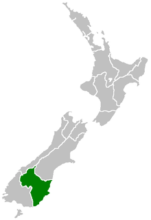
West Otago is the local name given to part of the region of Otago, New Zealand, lying close to the border with Southland. It is administratively connected to South Otago, but is geographically separated from it by a range of hills known as the Blue Mountains. The largest settlements in West Otago are Tapanui and Heriot, and other localities within the area include Moa Flat, Edievale, Merino Downs, and Waikoikoi. The area described as West Otago is sometimes extended to include Lawrence and Beaumont. The ghost town of Kelso also lies within West Otago. Other notable features of the area include Conical Hill and Landslip Hill, the latter being a major fossil-bearing formation.

South Island Southernmost of the two main islands in New Zealand

The South Island, also officially named Te Waipounamu, is the larger of the two major islands of New Zealand in surface area; the other being the smaller but more populous North Island. It is bordered to the north by Cook Strait, to the west by the Tasman Sea, and to the south and east by the Pacific Ocean. The South Island covers 150,437 square kilometres (58,084 sq mi), making it the world's 12th-largest island. It has a temperate climate.

New Zealand Country in Oceania

New Zealand is a sovereign island country in the southwestern Pacific Ocean. The country geographically comprises two main landmasses—the North Island, and the South Island —and around 600 smaller islands. New Zealand is situated some 2,000 kilometres (1,200 mi) east of Australia across the Tasman Sea and roughly 1,000 kilometres (600 mi) south of the Pacific island areas of New Caledonia, Fiji, and Tonga. Because of its remoteness, it was one of the last lands to be settled by humans. During its long period of isolation, New Zealand developed a distinct biodiversity of animal, fungal, and plant life. The country's varied topography and its sharp mountain peaks, such as the Southern Alps, owe much to the tectonic uplift of land and volcanic eruptions. New Zealand's capital city is Wellington, while its most populous city is Auckland.

The township is likely not to have been named after the Scottish border town of Heriot (unlike other local towns named after Borders places, such as Kelso and Roxburgh), but may have been named for from the maiden name of the wife of early settler William Pinkerton. [1]

Kelso, New Zealand human settlement

Kelso is an abandoned small settlement in Otago, New Zealand, located ten kilometres north of Tapanui on the Crookston Burn, close to its junction with the larger Pomahaka River. Its population during the 1960s and 1970s was close to 300, with most of its economy based on sheep farming. A small dairy factory was a focal point in the village's early years.

Roxburgh, New Zealand Town in Otago region, New Zealand

Roxburgh is a small New Zealand town of about 600 people in Central Otago. It is in Teviot Valley on the banks of the Clutha River, 40 km south of Alexandra in the South Island. State Highway 8, which links Central Otago with Dunedin city, passes through the town. Roxburgh is well known for its Roxdale fruit and "Jimmy's Pies."

The main economic activities in Heriot are related to livestock and forestry.

Related Research Articles

Haast River River of New Zealand

The Haast River has its terminus on the West Coast of the South Island of New Zealand.

Manuherikia River river in New Zealand

The Manuherikia River is located in Otago in the South Island of New Zealand. It rises in the far north of the Maniototo, with the West Branch draining the eastern side of the St Bathans Range, and the East Branch draining the western flanks of the Hawkdun Range. The river continues southwest through the wide Manuherikia Valley to its confluence with the Clutha River at Alexandra. During the 1860s the Manuherikia was one of the centres of the Central Otago Gold Rush.

Albert Town, New Zealand town in Queenstown-Lakes District, Otago Region, New Zealand

Albert Town is located to the east of Wanaka in Otago, New Zealand. Until recently only a farming settlement, the population boom in this area has led to much new development. The confluence of the Clutha and Hāwea Rivers is located here. The town was named after Prince Albert of Saxe-Coburg and Gotha. Albert Town was formerly called Newcastle.

Saint Bathans human settlement in New Zealand

The former gold and coal mining town of Saint Bathans, formerly named Dunstan Creek, lies deep in the heart of the Maniototo in New Zealand's Otago region. Mining has long ceased, and it is a tranquil holiday retreat. The preservation of many of its historic buildings makes it one of the region's more picturesque tourist venues. Saint Bathans is well known for its scenic man-made lake with beautiful looking clay cliffs that attract many tourists. It is currently a camping spot, and swimming is allowed in the lake.

The Dobson River is a river in the South Island of New Zealand. It flows south between the Neumann and Ohau ranges for 45 kilometres (28 mi) from its source to the east of Mount Hopkins, in the Southern Alps, before joining with the Hopkins River, close to the latter's entry into the northern end of Lake Ohau in the Mackenzie Country. The river flows over wide shingle beds, and has no rapids of interest to whitewater enthusiasts. It was named by Julius von Haast in the 1860s for his father-in-law, Edward Dobson, who was the Canterbury Provincial Engineer.

Ward, New Zealand Place in Marlborough, New Zealand

Ward is a small town in Marlborough, New Zealand, with a population of about 900 residents. It is located on State Highway 1, 82 kilometres (51 mi) north of Kaikoura. The Flaxbourne River flows past to the north and into the Pacific Ocean to the south-east of Ward. A current initiative aims to have the town renamed as Flaxbourne.

The Tapanui Branch was a railway line located near the border of the regions of Southland and Otago, New Zealand. Although the name suggests that it terminated in Tapanui, its furthest terminus was actually in Edievale. Construction of the line began in 1878 with the first section opened in 1880, and it operated until 1978, when it was destroyed by flooding from the Pomahaka River.

Beaumont, New Zealand settlement in Otago Region of New Zealand

Beaumont is a small town in inland Otago, in the South Island of New Zealand. It is located on the Clutha River six kilometres southeast of Raes Junction, between Roxburgh and Balclutha. Beaumont is connected to Milton and Roxburgh by State Highway 8.

Ettrick, New Zealand town in Central Otago District, Otago Region, New Zealand

Ettrick is a small town in inland Otago, in the South Island of New Zealand.

Owaka human settlement

Owaka is a small town in the Clutha District of South Otago, in the South Island of New Zealand. It is the largest community in the rugged, forested Catlins area, close to the border with Southland, some 35 km (22 mi) south of Balclutha on the Southern Scenic Route. The town's population was 334 in the 2006 census, a decrease of 39 from 2001. In the census figures, 72.9% of the population were European, and 15% were Māori.

Balfour, New Zealand town in New Zealand

Balfour is a small town located in the Southland region of New Zealand. According to the 2001 New Zealand census, it has a usually resident population of 135, unchanged from the previous census in 1996.

Otago Regional Council

Otago Regional Council (ORC) is the regional council for Otago in the South Island of New Zealand. The council's principal office is Regional House on Stafford Street in Dunedin, with smaller offices in Queenstown and Alexandra.

Kawarau Gorge canyon in New Zealand

The Kawarau Gorge is a major river gorge, located in Central Otago, in the South Island of New Zealand. The Kawarau River flows through the gorge, which is located between the towns of Queenstown and Cromwell, and part of the route of State Highway 6 also follows the gorge.

The Saxon River is a river of the Tasman Region of New Zealand's South Island. It flows northwest to reach the Big River 10 kilometres southeast off Kahurangi Point. The Saxon river's entire length is within Kahurangi National Park.

The small settlement of Caberfeidh is located in The Catlins, in the Otago region of New Zealand's South Island. The site of a former railway station on the Catlins Branch Line, it is sited close to a tributary of the Maclennan River, 5 kilometres north of the coast at Tahakopa Bay and 12 kilometres southwest of Owaka.

Waiwera South is a small settlement in the South Island of New Zealand, close to the boundary between the Otago and Southland regions. The settlement is located between Balclutha and Clinton, immediately to the south of State Highway 1, between branches of the Waiwera River and Kaihiku Stream, two minor tributaries of the Clutha River. The South Island Main Trunk railway also runs through the township. The settlement's population is around 100.

Wangaloa human settlement in New Zealand

Wangaloa is a small coastal settlement in South Otago, New Zealand. It is located to the north of the mouths of the Clutha River the beach area, close to the town of Kaitangata. There is access to Wangaloa Beach from the Kaitangata Golf course. Wangaloa is connected to Toko Mouth, 10 kilometres (6.2 mi) to the north, by a coastal road, and to Kaitangata, 5 kilometres (3.1 mi) to the west, by a road which crests a low range of coastal hills.

Edievale is a small settlement in West Otago, in New Zealand's South Island. It lies equidistant between Heriot, which lies to the west, and Raes Junction, which lies to the east, on SH 90.

References

  1. Wise's New Zealand guide: A gazetteer of New Zealand (4th ed.) (1969) Dunedin: H. Wise & Co. (N.Z.) Ltd.

Coordinates: 45°50′S169°16′E / 45.833°S 169.267°E / -45.833; 169.267

Geographic coordinate system Coordinate system

A geographic coordinate system is a coordinate system that enables every location on Earth to be specified by a set of numbers, letters or symbols. The coordinates are often chosen such that one of the numbers represents a vertical position and two or three of the numbers represent a horizontal position; alternatively, a geographic position may be expressed in a combined three-dimensional Cartesian vector. A common choice of coordinates is latitude, longitude and elevation. To specify a location on a plane requires a map projection.