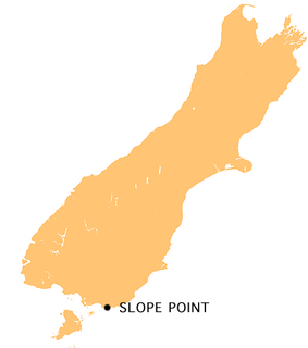
Slope Point is the southernmost point of the South Island of New Zealand.
The Catlins River Branch was a branch line railway that formed part of New Zealand's national rail network. It ran through the Catlins region in southwestern Otago and was built in sections between 1879 and 1915. It closed in 1971 except for the first four kilometres, which remain open as the Finegand Branch, formerly named the Finegand Industrial Siding. Along the line was the Hunts Road tunnel, the southernmost tunnel in New Zealand.
The Owaka River flows southeastward through The Catlins, an area of the southern South Island of New Zealand. Its total length is 30 kilometres (19 mi), and it shares the estuary of the Catlins River, flowing into the Pacific Ocean at Pounawea, 28 kilometres (17 mi) south of Balclutha. Its source is on the slopes of Mt Rosebery, 12 kilometres (7.5 mi) south of Clinton.
The Catlins River flows southeastward through The Catlins, an area of the southern South Island of New Zealand. Its total length is 42 kilometres (26 mi), and it flows into the Pacific Ocean at Pounawea, 28 kilometres (17 mi) south of Balclutha. Its upper estuary is called Catlins Lake, and its lower estuary is shared with the Owaka River.
The Tahakopa River flows southeastward through the Catlins, an area of the southern South Island of New Zealand. Its total length is 32 kilometres (20 mi), and it flows into the Pacific Ocean 30 kilometres (19 mi) east of Waikawa, close to the settlement of Papatowai.

Curio Bay is a coastal embayment in the Southland District of New Zealand, best known as the site of a petrified forest some 180 million years old. It also hosts a yellow-eyed penguin colony, arguably the rarest of penguin species, with approximately 1600 breeding pairs in the extant population. The bay, along with neighbouring Porpoise Bay, is home to the endemic Hector's dolphin. Southern right whales are occasionally observed offshore, as on numerous parts of the country's coast. Located near the southernmost point of the South Island, Curio Bay is one of the major attractions in the Catlins, attracting around 100,000 visitors per year. The town of Waikawa has an information center for tourists.
The Catlins Ranges are a series of rugged, roughly parallel hill ranges in the southeastern corner of New Zealand's South Island.
Pounawea is a small town in The Catlins, an area of the southern South Island of New Zealand. It is located four kilometres southwest of Owaka, at the mouth of the Catlins River. It is a popular holiday spot with a seasonal population, there are numerous cribs at the settlement.

Jack's Bay is a small settlement in The Catlins, an area on the southeastern corner of the South Island of New Zealand. It is located six kilometres southwest of Owaka, close to the mouth of the Catlins River. A popular holiday spot with a seasonal population, there are numerous cribs at the settlement. Jack's Bay is noted for a large blowhole, known as Jack's Blowhole, a 55-metre-deep blowhole that formed when part of a sea cavern's roof collapsed. The blowhole is 200 metres from the sea.
Kaka Point is a small town at the northern edge of The Catlins, an area of the southern South Island of New Zealand. It is located 14 km south of Balclutha and 8 km north of the headland of Nugget Point. It has a seasonally fluctuating population, and there are numerous cribs at the settlement. It has a permanent population of about 100. The settlement's best known resident was Māori poet Hone Tuwhare, who lived in Kaka Point for many years until his death in 2008. Kaka Point is named for the New Zealand kaka bird, whose signature call is "ka-aa." There is a restaurant, a motel, bed and breakfasts and a camping ground(s) there. http://www.lonelyplanet.com/new-zealand/the-catlins/things-to-do
Glenomaru is a small settlement in The Catlins, an area of the southern South Island of New Zealand. It is located 10 kilometres north of Owaka on the main road to Balclutha. On 7 July 1891, a branch line railway from the Main South Line in Balclutha was opened to Glenomaru, and the village remained the terminus of the line until it was extended to Tahora on 16 December 1895. This line ultimately terminated in Tahakopa and was known as the Catlins River Branch. It closed on 27 February 1971 and a sawmill now exists on the site of Glenomaru station, though some of the railway's old formation can be seen in the surrounding area and the Hunts Road tunnel is in the vicinity and can be walked.
Tahakopa is a small settlement in The Catlins, an area of the southern South Island of New Zealand. It is located 25 kilometres northeast of Waikawa on the Tahakopa River. On 17 February 1915, Tahakopa became the terminus of the Catlins River Branch railway and retained this status until the branch line was closed on 27 February 1971. From the line's opening until 12 August 1956, a railway locomotive depot was based in the village. The old station building and goods shed still stand today.
Mount Pye is a rugged hill in the southeast of the South Island of New Zealand. It is the highest point in the area known as the Catlins, rising to 720 m (2361 ft). It is located 40 km (25 mi) southeast of Gore, and forms part of the border between the Otago and Southland regions. The headwaters of many of the Catlins' rivers are located on the slopes of Mount Pye.

Waikawa is a small settlement in Southland, New Zealand, at the southwestern edge of The Catlins.
The Fleming River is a river of the eastern Catlins, New Zealand. A tributary of the Tautuku River, it rises west of Soaker Hill in the Maclennan Range and flows south-eastward through the Catlins Forest Park to join that river at Tautuku.
The Maclennan River is a river of New Zealand, a tributary of the Tahakopa River.
The Purakaunui River is a river in the western Catlins, New Zealand. It rises west of Houipapa and flows into the Pacific Ocean at Purakaunui Bay.

The Tautuku River originates in the Maclennan Range of The Catlins. It continues through native bush for almost its entire length, including McLean Falls. Near its mouth at Tautuku Bay, just north of Tautuku Peninsula, the river flows through the Tautuku Estuary, a breeding ground for fernbirds.
The Waipati River, alternatively known as the Chaslands River is a river in the eastern Catlins, New Zealand. It rises in the Maclennan Range and flows south-eastward into the Waipati Beach north of Chaslands Mistake.
The small settlement of Caberfeidh is located in The Catlins, in the Otago region of New Zealand's South Island. The site of a former railway station on the Catlins Branch Line, it is sited close to a tributary of the Maclennan River, 5 kilometres north of the coast at Tahakopa Bay and 12 kilometres southwest of Owaka.


