Finegand, New Zealand

Last updated
New Zealand location map.svg
Disc Plain red.svg
Finegand

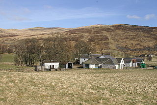
Finegand is a locality in the South Otago region of New Zealand's South Island. [1]

South Otago lies in the south east of the South Island of New Zealand. As the name suggests, it forms the southernmost part of the geographical region of Otago.

South Island Southernmost of the two main islands in New Zealand

The South Island, also officially named Te Waipounamu, is the larger of the two major islands of New Zealand in surface area; the other being the smaller but more populous North Island. It is bordered to the north by Cook Strait, to the west by the Tasman Sea, and to the south and east by the Pacific Ocean. The South Island covers 150,437 square kilometres (58,084 sq mi), making it the world's 12th-largest island. It has a temperate climate.

Contents

Named after Finegand, in Scotland, by John Shaw. John Shaw arrived in New Zealand in 1852, with his sister Margaret, from Finegand which is near Glenshee in Perthshire, Scotland. He took up land on the south bank of the Clutha River, and named his farm "Finegand".

Finegand village in United Kingdom

Finegand is a farming hamlet located in eastern Perth and Kinross, Scotland and also refers historically to the portion of lands surrounding the hamlet. Finegand is located in Glen Shee and encompasses the lands east of the Shee Water adjacent to a burn which joins it about 4 miles below the Spittal and about 18 miles north of Blairgowrie.

Scotland Country in Europe, part of the United Kingdom

Scotland is a country that is part of the United Kingdom. Sharing a border with England to the southeast, Scotland is otherwise surrounded by the Atlantic Ocean to the north and west, by the North Sea to the northeast and by the Irish Sea to the south. In addition to the mainland, situated on the northern third of the island of Great Britain, Scotland has over 790 islands, including the Northern Isles and the Hebrides.

Finegand is situated on the Clutha River south of Balclutha. Other nearby settlements include Otanomomo and Waitepeka to the south and Kakapuaka to the northwest.

Clutha River river in New Zealand

The Clutha River / Mata-Au is the second longest river in New Zealand and the longest in the South Island. It flows south-southeast 338 kilometres (210 mi) through Central and South Otago from Lake Wanaka in the Southern Alps to the Pacific Ocean, 75 kilometres (47 mi) south west of Dunedin. It is the highest volume river in New Zealand, and the swiftest, with a catchment of 21,960 square kilometres (8,480 sq mi), discharging a mean flow of 614 cubic metres per second (21,700 cu ft/s). The Clutha River is known for its scenery, gold-rush history, and swift turquoise waters. A river conservation group, the Clutha Mata-Au River Parkway Group, is working to establish a regional river parkway, with a trail, along the entire river corridor. The name of the river was changed to a dual name by the Ngai Tahu Claims Settlement Act 1998.

Balclutha, New Zealand Town in Otago, New Zealand

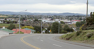
Balclutha is a town in Otago, lying towards the end of the Clutha River, on the east coast of the South Island of New Zealand. It is about halfway between Dunedin and Invercargill on the Main South Line railway, State Highway 1 and the Southern Scenic Route. Balclutha has a population of 3,990, and is the largest town in South Otago.

Otanomomo human settlement in New Zealand

Otanomomo is a locality in the South Otago region of New Zealand's South Island. It is situated on the banks of the Clutha River, roughly 6 km south of Balclutha. Nearby settlements include Finegand to the north, Paretai, Puerua, and Romahapa to the south, and Waitepeka to the west.

Economy

Finegand is located in a rural area and thus the economic emphasis is on agriculture. A major freezing works operated by Silver Fern Farms is located in Finegand. A multimillion-dollar upgrade of the facility was undertaken in 2007. [2]

Agriculture Cultivation of plants and animals to provide useful products

Agriculture is the science and art of cultivating plants and livestock. Agriculture was the key development in the rise of sedentary human civilization, whereby farming of domesticated species created food surpluses that enabled people to live in cities. The history of agriculture began thousands of years ago. After gathering wild grains beginning at least 105,000 years ago, nascent farmers began to plant them around 11,500 years ago. Pigs, sheep and cattle were domesticated over 10,000 years ago. Plants were independently cultivated in at least 11 regions of the world. Industrial agriculture based on large-scale monoculture in the twentieth century came to dominate agricultural output, though about 2 billion people still depended on subsistence agriculture into the twenty-first.

Slaughterhouse facility where animals are killed for consumption as food products

A slaughterhouse or abattoir is a facility where animals are slaughtered, most often to provide food for humans. Slaughterhouses supply meat, which then becomes the responsibility of a packaging facility.

Silver Fern Farms

Silver Fern Farms Limited is a New Zealand multinational meat company. It is owned in equal partnership by Silver Fern Farms Co-op Ltd, a cooperative of 16,000 New Zealand sheep, cattle and deer farmers and Shanghai Maling Aquarius Ltd. The company is New Zealand’s largest livestock processing and marketing company. It has investments in manufacturing, meat processing, transport of live stock, export logistics and meat marketing, with associated companies including, New Zealand and Australian Lamb Company Limited, The Lamb Co-Operative, Inc, Robotic Technologies Limited, Livestock Logistics Nationwide Limited. Kotahi Logistics LP, Ovine Automation Limited, FarmIQ Systems Ltd, Primary Collaboration NZ Ltd and the Red Meat Profit Partnership.

Transport

Finegand is situated on the Southern Scenic Route road, which meets State Highway 1 just to the north in Balclutha.

Southern Scenic Route road in New Zealand

The Southern Scenic Route is a tourist highway in New Zealand linking Queenstown, Fiordland, Te Anau and the iconic Milford Road to Dunedin via, Riverton, Invercargill and The Catlins. An Australian travel magazine labelled it "one of the world's great undiscovered drives" in 2008.

New Zealand State Highway 1 road in New Zealand

State Highway 1 is the longest and most significant road in the New Zealand road network, running the length of both main islands. It appears on road maps as SH 1 and on road signs as a white number 1 on a red shield, but it has the official designations SH 1N in the North Island, SH 1S in the South Island.

On 15 December 1885, the first section of the Catlins River Branch railway opened through Finegand. This branch line ultimately terminated in Tahakopa, with the Finegand station 3.6 km from the junction with the Main South Line in Balclutha. [3] At its peak in the first half of the 20th century, up to sixteen trains per week would pass through Finegand, primarily mixed trains. However, the line's profitability declined after World War II and it closed beyond Finegand on 27 February 1971. The first 4.05 km remain in operation as an industrial siding to serve the Silver Firm Farms freezing works and it is shunted as required by passing trains on the Main South Line. [4]

The Catlins River Branch was a branch line railway that formed part of New Zealand's national rail network. It ran through the Catlins region in southwestern Otago and was built in sections between 1879 and 1915. It closed in 1971 except for the first four kilometres, which remain open as the Finegand Branch, formerly named the Finegand Industrial Siding. Along the line was the Hunts Road tunnel, the southernmost tunnel in New Zealand.

Branch line Minor railway line

A branch line is a secondary railway line which branches off a more important through route, usually a main line. A very short branch line may be called a spur line. David Blyth Hanna, the first president of the Canadian National Railway, said that although most branch lines cannot pay for themselves, they are essential to make main lines pay.

Tahakopa human settlement in New Zealand

Tahakopa is a small settlement in The Catlins, an area of the southern South Island of New Zealand. It is located 25 kilometres northeast of Waikawa on the Tahakopa River. On 17 February 1915, Tahakopa became the terminus of the Catlins River Branch railway and retained this status until the branch line was closed on 27 February 1971. From the line's opening until 12 August 1956, a railway locomotive depot was based in the village. The old station building and goods shed still stand today.

Related Research Articles

Gore, New Zealand Town and district in Southland, New Zealand

Gore is a town and district in the Southland region of the South Island of New Zealand.

Manuherikia River river in New Zealand

The Manuherikia River is located in Otago in the South Island of New Zealand. It rises in the far north of the Maniototo, with the West Branch draining the eastern side of the St Bathans Range, and the East Branch draining the western flanks of the Hawkdun Range. The river continues southwest through the wide Manuherikia Valley to its confluence with the Clutha River at Alexandra. During the 1860s the Manuherikia was one of the centres of the Central Otago Gold Rush.

The Tuapeka River is located in Otago in the South Island of New Zealand. It is a tributary of the Clutha River, which it joins at Tuapeka Mouth between Roxburgh and Balclutha.

Clyde, New Zealand Town in Otago, New Zealand

Clyde, formerly Dunstan, is a small town in Central Otago, New Zealand with a population of 918 in 2006. It is located on the Clutha River, between Cromwell and Alexandra.

Clutha District Territorial authority in Otago, New Zealand

Clutha District is a local government district of southern New Zealand, with its headquarters in the Otago town of Balclutha. The Clutha District has a land area of 6,362.86 km² and a 2006 census population of 16,839 usual residents. Clutha District occupies the majority of the geographical area known as South Otago.

Inch Clutha is a large, flat island sitting in the delta between the Matau (northern) and Koau (southern) branches of the Clutha River, downstream from the town of Balclutha in the South Island of New Zealand. Approximately 10 kilometres (6 mi) long and 3 kilometres (2 mi) wide, the fertile but flood-prone land of the island is extensively farmed. The island was formed in 1878 after a massive flood changed the course of the Clutha, which had formerly reached the ocean 4 km to the south at Port Molyneux.

The Pomahaka River is in South Otago in New Zealand's South Island. It is a tributary of the Clutha River, flowing south for 80 kilometres (50 mi) from the Old Man Range of mountains to join the Clutha just north of Balclutha. Along its path it passes the Blue Mountains and the forestry town of Tapanui in the area known locally as West Otago.

The Kaitangata Line, also known as the Kaitangata Branch in its first years of operation, was a railway line in Otago, New Zealand. It was built by a private company and was later acquired by the government's Mines Department, and operated from 1876 until 1970. It provided a link from coal mines to the Main South Line, and was never integrated into the network managed by the New Zealand Railways Department, thus although it could be seen as a branch line of the Main South Line, it officially never was.

Beaumont, New Zealand settlement in Otago Region of New Zealand

Beaumont is a small town in inland Otago, in the South Island of New Zealand. It is located on the Clutha River six kilometres southeast of Raes Junction, between Roxburgh and Balclutha. Beaumont is connected to Milton and Roxburgh by State Highway 8.

Owaka human settlement

Owaka is a small town in the Clutha District of South Otago, in the South Island of New Zealand. It is the largest community in the rugged, forested Catlins area, close to the border with Southland, some 35 km (22 mi) south of Balclutha on the Southern Scenic Route. The town's population was 334 in the 2006 census, a decrease of 39 from 2001. In the census figures, 72.9% of the population were European, and 15% were Māori.

Romahapa human settlement in New Zealand

Romahapa is a locality in the Catlins region of Otago in New Zealand's South Island. It is located between the towns of Balclutha and Owaka. The last shop closed in 1977.

The Roxburgh Branch was a branch line railway built in the Otago region of New Zealand's South Island that formed part of the country's national rail network. Originally known as the Lawrence Branch, it was one of the longest construction projects in New Zealand railway history, beginning in the 1870s and not finished until 1928. The full line was closed in 1968.

Balclutha Road Bridge

The Balclutha Road Bridge, which spans the Clutha River in Balclutha, South Otago, New Zealand, is one of the best-known road bridges in New Zealand's South Island. The bridge is often simply known as "The Clutha Bridge", despite the fact that there are numerous bridges across the country's second longest river.

Waiwera South is a small settlement in the South Island of New Zealand, close to the boundary between the Otago and Southland regions. The settlement is located between Balclutha and Clinton, immediately to the south of State Highway 1, between branches of the Waiwera River and Kaihiku Stream, two minor tributaries of the Clutha River. The South Island Main Trunk railway also runs through the township. The settlement's population is around 100.

Port Molyneux

Port Molyneux is a tiny settlement on the coast of South Otago, New Zealand, close to the northeasternmost point of The Catlins. Now home only to farmland, it was a thriving port in the early years of New Zealand's European settlement.

References

  1. "Place name detail: Finegand". New Zealand Gazetteer. Land Information New Zealand . Retrieved 27 November 2007.
  2. Neal Wallace, "Meat Workers Remain Confident", Otago Daily Times (31 October 2007).
  3. New Zealand Railway and Tramway Atlas, fourth edition, edited by John Yonge (Essex: Quail Map Company, 1993), 28.
  4. David Leitch and Brian Scott, Exploring New Zealand's Ghost Railways, revised edition (Wellington: Grantham House, 1998 [1995]), 103-4.

Coordinates: 46°16′S169°44′E / 46.267°S 169.733°E / -46.267; 169.733