
The Waipori River is in Otago in the South Island of New Zealand. Rising in the Lammerlaw Range, it flows southeast for 50 kilometres (31 mi) before joining the Taieri River near Henley, 30 kilometres (19 mi) southwest of Dunedin of which it is officially the southernmost border.
Hampden, a rural township in North Otago, New Zealand, lies close to the North Otago coast, 35 kilometres south of Oamaru and 80 kilometres north of the city of Dunedin, to both of which it is connected by State Highway 1.
Macandrew Bay is located on the Otago Peninsula in the South Island of New Zealand. It is situated on the edge of Otago Harbour, and is named for pioneer settler James Macandrew who lived here during his later life. Early residents of the area called the bay "The Hundreds", due to the large number of boulders which covered the foreshore.

George Street is the main street of Dunedin, the second largest city in the South Island of New Zealand. It runs for two and a half kilometres north-northeast from The Octagon in the city centre to the foot of Pine Hill. It is straight and undulates gently as it skirts the edge of the hills to its northwest. South of The Octagon, Princes Street continues the line of George Street south-southwest for two kilometres.
Allanton is a small town in Otago, New Zealand, located some 20 kilometres southwest of Dunedin on State Highway 1. The settlement lies at the eastern edge of the Taieri Plains close to the Taieri River at the junction of the main road to Dunedin International Airport at Momona.
Clarksville is a small township located three kilometres southwest of Milton in the Otago region of the South Island of New Zealand. State Highways 1 and 8 meet in Clarksville. The town was also once the location of a railway junction, where the Roxburgh Branch left the Main South Line. Construction of this branch line began in the 1870s and Clarksville acted as the junction until 1907, when an extension of the branch was built alongside the Main South Line into Milton to improve operations. This led to Milton being the junction until 1960, when the extension was removed and Clarksville regained its status as a junction until the branch was entirely closed in 1968.
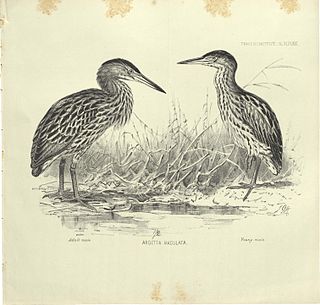
The New Zealand bittern is an extinct and enigmatic species of heron in the family Ardeidae. It was endemic to New Zealand and was last recorded alive in the 1890s.
Katiki is a small settlement in North Otago, New Zealand. It lies between the townships of Palmerston and Hampden on State Highway 1 at the northern end of Katiki Beach, close to the Moeraki Peninsula. The tip of the peninsula, Katiki Point, is the site of Katiki Point Lighthouse. The scenic reserve of Trotter's Gorge is located just inland of Katiki.

Toko Mouth is a settlement close to the south bank of the mouth of the Tokomairaro River, some 50 kilometres (31 mi) south of Dunedin and 15 kilometres (9.3 mi) southeast of Milton in Otago, New Zealand.

St Leonards is a suburb of the New Zealand city of Dunedin. It is located close to the northern shore of the Otago Harbour and on the hilly slopes above the harbour. St Leonards is 8.5 kilometres (5.3 mi) northeast of Dunedin's city centre, between the small settlement of Burkes and Sawyers Bay. St Leonards was named by early settler David Carey for the birthplace of his wife, the English town of St Leonards-on-Sea, on the Sussex coast.
Mornington is a suburb of the city of Dunedin, in the South Island of New Zealand. It is situated on hilly slopes 2 kilometres (1.2 mi) to the west of the city centre, the slopes forming part of a ridge which surrounds the heart of the city.
Ravensbourne is a suburb of the New Zealand city of Dunedin. It is located on the steep southeastern slopes of Signal Hill above the Otago Harbour. It lies on the harbour's northern shore, 4.5 kilometres (2.8 mi) east-northeast of the city centre. Ravensbourne's 2001 population was 1,269.
Kensington is a small suburb of the New Zealand city of Dunedin, nestled to the south of a hilly spur between the central city and the major suburb of South Dunedin, some 2.4 kilometres (1.5 mi) to the south of the city centre. The suburb was named for the leafy London suburb, possibly by John Hyde Harris, who subdivided the area in the 1860s.
Trotters Gorge is a locality in the Otago region, in the South Island of New Zealand. It is located 12 kilometres to the north of Palmerston, inland from State Highway 1. The gorge and the creek which runs through it were named for the family of early settler W. S. Trotter.

Bendigo is a settlement and historic area in Central Otago, in the southern South Island of New Zealand. It is located some 20 kilometres to the north of Cromwell, to the east of the head of Lake Dunstan, on the banks of the Bendigo Creek, a small tributary of the Clutha River.
Waiwera South is a small settlement in the South Island of New Zealand, close to the boundary between the Otago and Southland regions. The settlement is located between Balclutha and Clinton, immediately to the south of State Highway 1, between branches of the Waiwera River and Kaihiku Stream, two minor tributaries of the Clutha River. The South Island Main Trunk railway also runs through the township. The settlement's population is around 100.

Hoopers Inlet is one of two large inlets in the Pacific coast of Otago Peninsula, in the South Island of New Zealand.
Hindon is a small settlement in inland Otago, in the South Island of New Zealand. It is located 24 kilometres northwest of Dunedin in the Silverpeaks Range, close to the edge of the Strath Taieri. The Taieri Gorge Railway runs through Hindon on its way between Dunedin and Middlemarch.
Kyeburn is a small settlement in Otago, in the South Island of New Zealand. It lies on the Maniototo, a wide, high plain stretching from the end of the Strath-Taieri valley.


