Otago is a region of New Zealand located in the southern half of the South Island administered by the Otago Regional Council. It has an area of approximately 32,000 square kilometres (12,000 sq mi), making it the country's second largest local government region. Its population was 254,600 in June 2023.
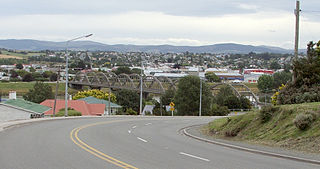
Balclutha is a town in South Otago, lying towards the end of the Clutha River, on the east coast of the South Island of New Zealand. It is about halfway between Dunedin and Gore on the Main South Line railway, State Highway 1 and the Southern Scenic Route. Balclutha has a population of 4,340, and is the largest town in South Otago.

The Clutha River is the second longest river in New Zealand and the longest in the South Island. It flows south-southeast 338 kilometres (210 mi) through Central and South Otago from Lake Wānaka in the Southern Alps to the Pacific Ocean, 75 kilometres (47 mi) south west of Dunedin. It is the highest volume river in New Zealand, and the swiftest, with a catchment of 21,000 square kilometres (8,100 sq mi), discharging a mean flow of 614 cubic metres per second (21,700 cu ft/s). The river is known for its scenery, gold-rush history, and swift turquoise waters. A river conservation group, the Clutha Mata-Au River Parkway Group, is working to establish a regional river parkway, with a trail, along the entire river corridor.
Kaitangata is a town near the coast of South Otago, New Zealand, on the left bank of the Matau Branch of the Clutha River ten kilometres south east of Balclutha. The town is known to its residents simply as Kai.

The Catlins comprise an area in the southeastern corner of the South Island of New Zealand. The area lies between Balclutha and Invercargill, straddling the boundary between the Otago and Southland regions. It includes the South Island's southernmost point, Slope Point.
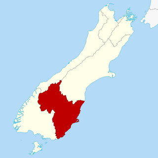
South Otago lies in the south east of the South Island of New Zealand. As the name suggests, it forms the southernmost part of the geographical region of Otago.

Clutha District is a local government district of southern New Zealand, with its headquarters in the Otago town of Balclutha. Clutha District has a land area of 6,334.47 km2 (2,445.75 sq mi) and an estimated population of 18,900 as of June 2023. Clutha District occupies the majority of the geographical area known as South Otago.
Inch Clutha is a large, flat island sitting in the delta between the Matau (northern) and Koau (southern) branches of the Clutha River, downstream from the town of Balclutha in the South Island of New Zealand. Approximately 10 kilometres (6 mi) long and 3 kilometres (2 mi) wide, the fertile but flood-prone land of the island is extensively farmed. The island was formed in 1878 after a massive flood changed the course of the Clutha, which had formerly reached the ocean 4 km to the south at Port Molyneux.

Beaumont is a small town in inland Otago, in the South Island of New Zealand. It is located on the Clutha River / Mata-Au six kilometres southeast of Raes Junction, between Roxburgh and Balclutha. Beaumont is connected to Milton and Roxburgh by State Highway 8.

Owaka is a small town in the Clutha District of South Otago, in the South Island of New Zealand. It is the largest community in the rugged, forested Catlins area, close to the border with Southland, some 35 km (22 mi) south of Balclutha on the Southern Scenic Route.
The Otago region of New Zealand is one of the more isolated places of the inhabited earth. Its high latitude, elevation and distance from larger foreign and domestic population centres have defined Otago at each stage of its history.
Finegand is a locality in the South Otago region of New Zealand's South Island.
The Pūerua River, prior to 2018 spelled Puerua River, is a river in South Otago, New Zealand. A tributary of the Clutha River / Mata-Au, it rises east of Brown Dome and flows eastward to join that river near Port Molyneux.
Clutha County was one of the counties of New Zealand in the South Island. Its first meeting was on 4 January 1877 at the Balclutha courthouse. The offices on the corner of Clyde and Elizabeth Streets in Balclutha were rebuilt in 1934 and demolished in 2009. Clutha District Council began in November 1989 with amalgamation of Balclutha Borough, Clutha County, Lawrence Borough, Tapanui Borough, part of Tuapeka County and Bruce District Council. Bruce District Council had been formed in 1986 from Bruce County, Milton Borough and Kaitangata Borough.
Waiwera South is a small settlement in the South Island of New Zealand, close to the boundary between the Otago and Southland regions. The settlement is located between Balclutha and Clinton, immediately to the south of State Highway 1, between branches of the Waiwera River and Kaihiku Stream, two minor tributaries of the Clutha River. The South Island Main Trunk railway also runs through the township. The settlement's population is around 100.
Wangaloa is a small coastal settlement in South Otago, New Zealand. It is located to the north of the mouths of the Clutha River the beach area, close to the town of Kaitangata. There is access to Wangaloa Beach from the Kaitangata Golf course. Wangaloa is connected to Toko Mouth, 10 kilometres (6.2 mi) to the north, by a coastal road, and to Kaitangata, 5 kilometres (3.1 mi) to the west, by a road which crests a low range of coastal hills.
Clutha District Council is the territorial authority for the Clutha District of New Zealand.
The Koau and Matau Rivers, also called the Koau and Matau Branches, are the two distributaries of New Zealand's Clutha River. The two distributaries split immediately to the southeast of the town of Balclutha, at which point the more northerly branch becomes the Matau and the more southerly becomes the Koau. The two branches both flow generally southeast to reach the Pacific Ocean, surrounding the island of Inch Clutha. A small silty channel connects the two rivers close to their mouths, creating a smaller unnamed island to the south of Inch Clutha.

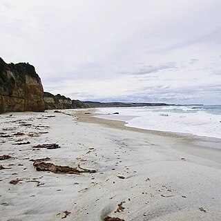
Molyneux Bay is a bay on the south east coast of the South Island in the Otago Region of New Zealand. The bay is the location of the mouth of the Clutha River / Mata-Au and the estuarial river island of Inch Clutha. It stretches for some 12 kilometres (7.5 mi) and is bounded in the northeast by a small promontory close to Summer Hill and in the southwest by the headland of Kaka Point.
