Clyde Dam

Last updated
Clyde Dam
Clydedam.jpg
Clyde Dam from the east, looking west
New Zealand relief map.jpg
Disc Plain red.svg
Location of Clyde Dam in New Zealand
Location Clyde, Otago, New Zealand
Coordinates 45°10′46″S169°18′25″E / 45.179314°S 169.306955°E / -45.179314; 169.306955 Coordinates: 45°10′46″S169°18′25″E / 45.179314°S 169.306955°E / -45.179314; 169.306955
Dam and spillways
Type of dam Concrete gravity dam
Impounds Clutha River
Height100 m (330 ft)
Length490 m (1,610 ft)
Width (crest)10 m (33 ft)
Width (base)70 m (230 ft)
Reservoir
Creates Lake Dunstan
Surface area26 km2 (10 sq mi)
Power Station
Operator(s) Contact Energy
Commission date1992
Turbines 4× 10⁸ MW (145,000 hp) Francis turbines
Installed capacity 464 MW [1]
Annual generation 2,100 GWh

The Clyde Dam, New Zealand's third-largest hydroelectric dam, [Note 1] is built on the Clutha River / Mata-Au near the town of Clyde. It is owned and operated by Contact Energy.

Contents

History

Clyde Dam under construction circa 1986 Clyde Dam Under Construction.jpg
Clyde Dam under construction circa 1986

There was considerable controversy when the dam was planned because it would flood many houses and orchards upstream at Cromwell, [2] as well as the scenic Cromwell Gorge, which was a highlight of the then young but growing New Zealand tourism industry. Construction also required replacement of a stretch of highway [3] and the closure of the Otago Central Railway beyond Clyde, though materials for the dam would provide significant traffic for the rest of the line which was experiencing a drop in freight tonnage. To mitigate these problems, the Kirk Labour government decided a low dam should be built at Clyde. This decision was overturned by the following National government, who preferred a high dam. [4]

There was also debate about whether the dam was needed. National's support for a controversial aluminium smelter at Aramoana, another of Prime Minister Sir Robert Muldoon's Think Big projects of the late 1970s and early 1980s, was one justification propounded for the dam. [4] An initial grant of water rights for the dam was overturned by the High Court following an appeal by landowners. National overturned this decision, after bargaining for the support of Social Credit (who had initially opposed a high dam), in the Clutha Development (Clyde Dam) Empowering Act 1982. [2] [4] The Act was later repealed by the following National government on 1 October 1991, when it was superseded by the Resource Management Act 1991. [5]

Expansion joint Clyde Dam expansion joint, Otago, NZ.jpg
Expansion joint

The dam was constructed between 1982 and 1993. Filling it was done in four controlled stages beginning in April 1992, and completed the following year, creating Lake Dunstan. [2] The power station has a capacity of four 120 MVA (116 MW) Francis turbines (for a total of 464 MW), but was only allowed to run 432 MW due to resource consent conditions. The dam was built with two additional penstocks, allowing additional turbines to be installed in future. [6] The resource consent was changed in 2005 to allow the full 464 MW to be produced.

During construction, the adjacent rock was discovered to be microfractured, because of an earthquake fault running underneath the dam site. The dam was redesigned, losing a sluice channel and cutting its generation capacity from 612 MW to 464 MW. A slip joint was built into the dam to accommodate 1–2 metres of potential ground movement, [7] [8] and a large amount of slurry cement was pumped into the rock to stop water leaks. This additional work was one reason for a major project cost overrun, which made the dam the most expensive in New Zealand. The other areas of overrun were due to stabilisation of landslides in the Cromwell Gorge. [9] [10] There are over 18 km of tunnels throughout the gorge for draining purposes. Because of all this extra work it overran the budget by nearly an extra 50% and delayed the filling of Lake Dunstan by a few years.

Maintenance workers accidentally activated fire alarms in the dam on 15 December 2008. The alarms triggered the release of a large bank of CO2 cylinders at the generators, flooding the equipment with the gas. Extractor fans to clear the CO2 then activated, and firefighters with breathing apparatus and gas detectors checked through the dam to ensure it had cleared. [11]

Trivia

The Clyde Dam, while still under construction, was used for on-location filming in the 1985 movie Shaker Run. [12]

See also

Notes

Related Research Articles

Otago is a region of New Zealand located in the southern half of the South Island administered by the Otago Regional Council. It has an area of approximately 32,000 square kilometres (12,000 sq mi), making it the country's second largest local government region. Its population was 246,000 in June 2022.

<span class="mw-page-title-main">Alexandra, New Zealand</span> Town in Otago, New Zealand

Alexandra is a town in the Central Otago district of the South Island of New Zealand. It is on the banks of the Clutha River, on State Highway 8, 188 kilometres (117 mi) by road from Dunedin and 33 kilometres (21 mi) south of Cromwell. The nearest towns to Alexandra via state highway 8 are Clyde seven kilometers to the northwest and Roxburgh forty kilometers to the south. State highway 85 also connects Alexandra to Omakau, Lauder, Oturehua, Ranfurly and on to Palmerston on the East Otago coast.

<span class="mw-page-title-main">Clutha River</span> River in the South Island of New Zealand

The Clutha River is the second longest river in New Zealand and the longest in the South Island. It flows south-southeast 338 kilometres (210 mi) through Central and South Otago from Lake Wānaka in the Southern Alps to the Pacific Ocean, 75 kilometres (47 mi) south west of Dunedin. It is the highest volume river in New Zealand, and the swiftest, with a catchment of 21,960 square kilometres (8,480 sq mi), discharging a mean flow of 614 cubic metres per second (21,700 cu ft/s). The river is known for its scenery, gold-rush history, and swift turquoise waters. A river conservation group, the Clutha Mata-Au River Parkway Group, is working to establish a regional river parkway, with a trail, along the entire river corridor.

<span class="mw-page-title-main">Cromwell, New Zealand</span> Town in Otago, New Zealand

Cromwell is a town in Central Otago region of the South Island of New Zealand. Cromwell is located on the shores of Lake Dunstan where the Kawarau river joins Lake Dunstan. Cromwell was established during the Otago gold rush and is now more known as one of the sub regions of the Central Otago wine region. In 2018, the town of Cromwell was home to a population of 5610 people.

<span class="mw-page-title-main">Kawarau River</span> River in the South Island of New Zealand

The Kawarau River is a river in the South Island of New Zealand. It drains Lake Wakatipu in northwestern Otago via the lake's Frankton Arm. The river flows generally eastwards for about 60 kilometres (37 mi) and passes through the steep Kawarau Gorge until it joins Lake Dunstan near Cromwell. Before the construction of the Clyde High Dam, the Kawarau joined the Clutha River / Mata-Au in a spectacular confluence at Cromwell. The Shotover River enters the Kawarau from the north; the Nevis River enters it from the south. With many rapids and strong currents, the river can be dangerous and has claimed many lives. It is popular for bungy jumping and kayaking.

<span class="mw-page-title-main">Lake Dunstan</span> Body of water

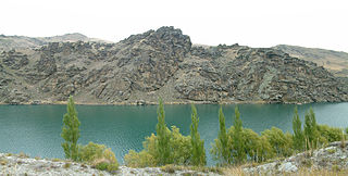
Lake Dunstan is a man-made lake and reservoir in the South Island of New Zealand.

<span class="mw-page-title-main">Cromwell Gorge</span> Canyon in New Zealand

The Cromwell Gorge is a deep gorge on the Clutha River in the Otago region of New Zealand's South Island. It stretches for 20 km south of the town of Cromwell towards Alexandra. It is one of three substantial river gorges in Central Otago, the others being the Kawarau Gorge to the west of Cromwell, and the Roxburgh Gorge downstream from Alexandra.

<span class="mw-page-title-main">Clyde, New Zealand</span> Town in Otago, New Zealand

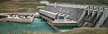
Clyde, formerly Dunstan, is a small town in Central Otago, New Zealand with a population of 1,270 in June 2022. It is located on the Clutha River, between Cromwell and Alexandra.

<span class="mw-page-title-main">Roxburgh Dam</span> Dam in Central Otago, New Zealand

The Roxburgh Dam is the earliest of the large hydroelectric projects in the lower half of the South Island of New Zealand. It lies across the Clutha River / Mata-Au, some 160 kilometres (99 mi) from Dunedin, some 9 kilometres (5.6 mi) to the north of the town of Roxburgh. The settlement of Lake Roxburgh Village is close to the western edge of the dam.

<span class="mw-page-title-main">Otago Central Railway</span> Branch railway line in Otago, New Zealand

The Otago Central Railway (OCR) or in later years Otago Central Branch Railway, now often referred to as the Taieri Gorge Railway, was a secondary railway line in Central Otago, in the South Island of New Zealand.

<span class="mw-page-title-main">Aviemore Dam</span> Dam in Canterbury/Otago, New Zealand

The Aviemore Dam is a dam on the Waitaki River in New Zealand. The dam is a composite dam, with an embankment section, and a concrete section. Built in the 1960s it impounds Lake Aviemore.

<span class="mw-page-title-main">Wind power in New Zealand</span> Overview of wind power in New Zealand

Wind power constitutes a small but growing proportion of New Zealand's electricity. As of December 2020, wind power accounts for 690 MW of installed capacity and over 5 percent of electricity generated in the country.

The electricity sector in New Zealand uses mainly renewable energy, such as hydropower, geothermal power and increasingly wind energy. As of 2019, 82% of electricity is generated from renewable sources, making New Zealand one of the countries with the lowest carbon dioxide emissions from electricity generation. Electricity demand grew by an average of 2.1% per year from 1974 to 2010 but decreased by 1.2% from 2010 to 2013.

<span class="mw-page-title-main">State Highway 8 (New Zealand)</span> Road in New Zealand

State Highway 8 is one of New Zealand's eight national highways. It forms an anticlockwise loop through the southern scenic regions of the Mackenzie Basin and Central Otago, starting and terminating in junctions with State Highway 1. Distances are measured from north to south.

Lowburn is a small settlement in Central Otago, in the South Island of New Zealand. It is located close to the shores of the man-made Lake Dunstan, which was formed by the building of the Clyde Dam. Lowburn lies between the towns of Wanaka and Cromwell.

<span class="mw-page-title-main">Hydroelectric power in New Zealand</span>

Hydroelectric power in New Zealand has been a part of the country's energy system for over 100 years and continues to provide more than half of the country's electricity needs. Hydroelectricity is the primary source of renewable energy in New Zealand. Power is generated the most in the South Island and is used most in the North Island.

<span class="mw-page-title-main">Clutha Mata-Au River Parkway Group</span>

The Clutha Mata-Au River Parkway Group, New Zealand, was formed in October 2003, and is an Incorporated Society. The Group was set up in response to land development issues along the Clutha River / Mata-Au corridor, much of which has high scenic and recreational values. The project aims to establish a regional river parkway, including a river trail, along the entire 338 km river corridor from Lake Wānaka to the Pacific Ocean.

The Save Aramoana Campaign was formed in 1974 to oppose a proposed aluminium smelter at Aramoana in New Zealand.

<span class="mw-page-title-main">National Grid (New Zealand)</span> Overview of the electrical grid in New Zealand

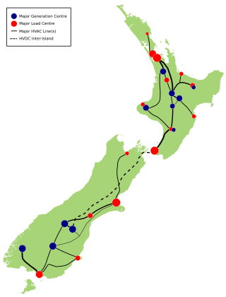
The National Grid is the nationwide system of electric power transmission in New Zealand. The grid is owned, operated and maintained by Transpower New Zealand, a state-owned enterprise, although some lines are owned by local distribution companies and leased to Transpower. In total, the national grid contains 11,803 kilometres (7,334 mi) of high-voltage lines and 178 substations.

References

  1. Hydroelectricity: turning water into power Archived 2010-05-24 at the Wayback Machine , Contact Energy.
  2. 1 2 3 Gilchrist, Shane (31 January 2009). "Reflections on Lake Dunstan". Otago Daily Times. Retrieved 2009-03-18.
  3. Dai Redshaw (1997). Sustainable Energy Archived 2008-10-16 at the Wayback Machine , New Zealand Science Monthly, March 1997.
  4. 1 2 3 Aynsley John Kellow (1996). Transforming power: the politics of electricity planning. Cambridge University Press. ISBN   978-0-521-47122-0.
  5. "Resource Management Act 1991 No 69 - New Zealand Legislation". Archived from the original on 4 April 2012. Retrieved 30 December 2010.
  6. "Clyde Dam factsheet" (PDF). Contact Energy. Retrieved 26 November 2021.
  7. Fault Provisioned Design Examples Archived 2011-07-22 at the Wayback Machine , Chapter 7 in Key Points for Rational Design for Civil-Infrastructures near Seismic Faults Reflecting Soil-Structure Interaction Features Archived 2011-07-22 at the Wayback Machine , Japan Society for Promoting Science, 2007.
  8. Eileen McSaveney. Earthquakes - Building for earthquake resistance Archived 2011-03-10 at the Wayback Machine , Te Ara - the Encyclopedia of New Zealand. Updated 2 March 2009.
  9. Michael J. Crozier. Landslides - People and landslides, Te Ara - the Encyclopedia of New Zealand. Updated 2 March 2009.
  10. Vicki Hyde (1990). Slip Sliding Away, New Zealand Science Monthly, November 1990 (Via Archive.org).
  11. Brown, Diane (16 December 2008). "Gas cylinders inadvertently activated at Clyde dam". Otago Daily Times. Retrieved 2008-12-15.
  12. "Shaker Run". IMDB.

Further reading