List of Mayors of Clutha
| Name | Portrait | Term | |
|---|---|---|---|
| 1 | Keith Fyall |  | 1989–1998 |
| 2 | Juno Hayes |  | 1998–2010 |
| 3 | Bryan Cadogan | | 2010–current |
| Mayor of Clutha District | |
|---|---|
| Style | His Worship |
| Term length | Three years, renewable |
| Inaugural holder | Keith Fyall |
| Formation | 1989 |
| Deputy | Ken Payne |
| Salary | $124,638 [1] |
| Website | Official website |
The Mayor of Clutha officiates over the Clutha District of New Zealand which is administered by the Clutha District Council.
The current mayor is Bryan Cadogan. [2]
| Name | Portrait | Term | |
|---|---|---|---|
| 1 | Keith Fyall | | 1989–1998 |
| 2 | Juno Hayes | | 1998–2010 |
| 3 | Bryan Cadogan | | 2010–current |
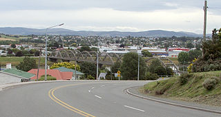
Balclutha is a town in South Otago, lying towards the end of the Clutha River, on the east coast of the South Island of New Zealand. It is about halfway between Dunedin and Gore on the Main South Line railway, State Highway 1 and the Southern Scenic Route. Balclutha has a population of 4,430, and is the largest town in South Otago.

The Clutha River is the second longest river in New Zealand and the longest in the South Island. It flows south-southeast 338 kilometres (210 mi) through Central and South Otago from Lake Wānaka in the Southern Alps to the Pacific Ocean, 75 kilometres (47 mi) south west of Dunedin. Gold is in abundance in the Clutha River and its surrounding areas. It is the highest volume river in New Zealand, and has a discharging mean flow of 614 cubic metres per second (21,700 cu ft/s).

A system of counties of New Zealand was instituted after the country dissolved its provinces in 1876, and these counties were similar to other countries' systems, lasting with little change until 1989, when they were reorganised into district and city councils within a system of larger regions.
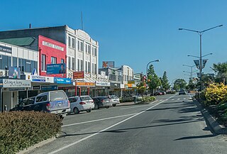
Kaitangata is a town near the coast of South Otago, New Zealand, on the left bank of the Matau Branch of the Clutha River ten kilometres south east of Balclutha. The town is known to its residents as Kai.

Central Otago is an area located in the inland part of the Otago region in the South Island of New Zealand. The motto for the area is "A World of Difference".

The Catlins comprise an area in the southeastern corner of the South Island of New Zealand. The area lies between Balclutha and Invercargill, straddling the boundary between the Otago and Southland regions. It includes the South Island's southernmost point, Slope Point.

The 1957 New Zealand general election was a nationwide vote to determine the shape of the New Zealand Parliament's 32nd term. It saw the governing National Party narrowly defeated by the Labour Party. The 1957 elections marked the beginning of the second Labour government, although this administration was to last only a single term.

Clutha District is a local government district of southern New Zealand, with its headquarters in the Otago town of Balclutha. Clutha District has a land area of 6,334.47 km2 (2,445.75 sq mi) and an estimated population of 19,300 as of June 2024. Clutha District occupies the majority of the geographical area known as South Otago.
Nantan is a city located in Kyoto Prefecture, Japan. As of 1 May 2022, the city had an estimated population of 30,744 in 14406 households and a population density of 50 persons per km2. The total area of the city is 616.40 square kilometres (237.99 sq mi).
Clutha was a New Zealand parliamentary electorate from 1866 to 1996.
John Edie was a Liberal Party Member of Parliament in the Otago region of New Zealand. He was a surveyor and an engineer, and also spent time as a farmer. He was Mayor of Lawrence.
James William Thomson was a 19th-century conservative Member of Parliament in New Zealand.
Gore District is a district in the Southland Region of the South Island of New Zealand. It is named for Gore, the district's biggest township.
Clutha County was one of the counties of New Zealand in the South Island. Its first meeting was on 4 January 1877 at the Balclutha courthouse. The offices on the corner of Clyde and Elizabeth Streets in Balclutha were rebuilt in 1934 and demolished in 2009. Clutha District Council began in November 1989 with amalgamation of Balclutha Borough, Clutha County, Lawrence Borough, Tapanui Borough, part of Tuapeka County and Bruce District Council. Bruce District Council had been formed in 1986 from Bruce County, Milton Borough and Kaitangata Borough.
Clutha District Council is the territorial authority for the Clutha District of New Zealand.
The 2019 New Zealand local elections were triennial elections held in New Zealand on Saturday 12 October 2019.
Bryan Alexander Cadogan is a New Zealand politician who has served as the mayor of Clutha since 2010. A retailer and former sheep shearer, he was first elected as a Clutha District Councillor in 1998. His younger brother, Tim Cadogan, was the mayor of Central Otago between 2016 and 2024.
The 2022 New Zealand local elections were triennial elections held in New Zealand on Saturday 8 October 2022. Voting began by postal vote on 16 September and ended at noon on 8 October 2022.
Tim Cadogan is a New Zealand politician who served as the Mayor of Central Otago between 2016 and 2024. Cadogan worked as a radio broadcaster and lawyer before becoming Mayor. In late October 2024, Cadogan resigned as Mayor and moved to Wellington to work as the Local Government Engagement Specialist at the Taumata Arowai water services authority. He is the younger brother of Bryan Cadogan, the Mayor of Clutha.

In early October 2024, the Otago region of New Zealand's South Island experienced heavy rainfall and significant flooding and landslides. The weather event affected coastal areas in Otago including North Otago, Dunedin, and the Clutha District, which received an estimated two-months worth of rainfall between 2 and 4 October. On 3 October, a state of emergency was declared in Dunedin, with residents in some low-lying suburbs being told to evacuate. By 4 October, the Clutha District had also declared a state of emergency. By 6 October, the state of emergency in Dunedin and Clutha had been lifted due to improving weather conditions and floodwaters subsiding.
| | This article about New Zealand politics is a stub. You can help Wikipedia by expanding it. |