Toetoes Bay is the easternmost of three large bays lying on the Foveaux Strait coast of Southland, New Zealand, the others being Te Waewae Bay and Oreti Beach. The 190 km Mataura River drains to sea at Toetoes Bay, first passing through the Toetoes Harbour estuary. Thirty kilometres in length, the bay is the southern end of the Awarua Plain, an area of swampy land stretching inland for about fifteen kilometres. The eastern end of the bay is close to Slope Point, the South Island's southernmost point, and the western end of the Catlins.
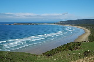
Oreti Beach is the central bay of three lying on the Foveaux Strait coast of Southland, New Zealand, the others being Te Waewae Bay and Toetoes Bay. Twenty-six kilometres in length, the bay lies between the town of Riverton and the outflow of the Aparima River in the northwest, and the estuary of the Oreti River in the southeast.

Owaka is a small town in the Clutha District of South Otago, in the South Island of New Zealand. It is the largest community in the rugged, forested Catlins area, close to the border with Southland, some 35 km (22 mi) south of Balclutha on the Southern Scenic Route. The town's population was 334 in the 2006 census, a decrease of 39 from 2001. In the census figures, 72.9% of the population were European, and 15% were Māori.

Lake Wilkie is a small, scenic lake near Tautuku Bay in the Catlins, south of Dunedin, New Zealand. It formed after the last ice age and has gradually shrunk to its current size of 1.7 hectares (4.2 acres). Bog lakes like Lake Wilkie are a rare ecosystem in this part of the country.
The Owaka River flows southeastward through The Catlins, an area of the southern South Island of New Zealand. Its total length is 30 kilometres (19 mi), and it shares the estuary of the Catlins River, flowing into the Pacific Ocean at Pounawea, 28 kilometres (17 mi) south of Balclutha. Its source is on the slopes of Mt Rosebery, 12 kilometres (7.5 mi) south of Clinton.
The Catlins River flows southeastward through The Catlins, an area of the southern South Island of New Zealand. Its total length is 42 kilometres (26 mi), and it flows into the Pacific Ocean at Pounawea, 28 kilometres (17 mi) south of Balclutha. Its upper estuary is called Catlins Lake, and its lower estuary is shared with the Owaka River.

Curio Bay is a coastal embayment in the Southland District of New Zealand, best known as the site of a petrified forest some 180 million years old. It also hosts a yellow-eyed penguin colony, arguably the rarest of penguin species, with approximately 1600 breeding pairs in the extant population. The bay, along with neighbouring Porpoise Bay, is home to the endemic Hector's dolphin. Southern right whales are occasionally observed offshore, as on numerous parts of the country's coast. Located near the southernmost point of the South Island, Curio Bay is one of the major attractions in the Catlins, attracting around 100,000 visitors per year. The town of Waikawa has an information center for tourists.
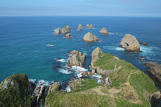
Nugget Point is one of the most iconic landforms on the Otago coast. Located at the northern end of the Catlins coast, along the road from Kaka Point, this steep headland has a lighthouse at its tip, surrounded by rocky islets. The point is home to many seabirds, including penguins, gannets and royal spoonbills, and a large breeding colony of fur seals. Roaring Bay, on the south coast of the tip of Nugget Point, is home to a small colony of yellow-eyed penguins.
The Catlins Ranges are a series of rugged, roughly parallel hill ranges in the southeastern corner of New Zealand's South Island.
Jack's Bay is a small settlement in The Catlins, an area on the southeastern corner of the South Island of New Zealand. It is located six kilometres southwest of Owaka, close to the mouth of the Catlins River. A popular holiday spot with a seasonal population, there are numerous cribs at the settlement. Jack's Bay is noted for a large blowhole, known as Jack's Blowhole, a 55-metre-deep blowhole that formed when part of a sea cavern's roof collapsed. The blowhole is 200 metres from the sea.
Maclennan is a small settlement in The Catlins, an area of the southern South Island of New Zealand. It is located 20 kilometres southwest of Owaka. From 1915 until its closure on 27 February 1971, the Catlins River Branch railway passed through the village, and the station building and goods shed still stand today.

The Cathedral Caves are one of the thirty longest sea caves in the world, located on Waipati Beach, 15 kilometres (9.3 mi) south of Papatowai, on the Catlins Coast in the southeast corner of the South Island, New Zealand. They are one of the most popular tourist attractions in the area, along with the McLean Falls, the highest water falls in the Catlins, located 4.9 kilometres (3.0 mi) away. The two main cave systems join together within the cliff and one has a 30 metres (98 ft) high ceiling. Often blue penguins and fur seals will emerge from the gloom at the far end of the cave.

Waikawa is a small settlement in Southland, New Zealand, at the southwestern edge of The Catlins.
The Fleming River is a river of the eastern Catlins, New Zealand. A tributary of the Tautuku River, it rises west of Soaker Hill in the Maclennan Range and flows south-eastward through the Catlins Forest Park to join that river at Tautuku.
The small settlement of Caberfeidh is located in The Catlins, in the Otago region of New Zealand's South Island. The site of a former railway station on the Catlins Branch Line, it is sited close to a tributary of the Maclennan River, 5 kilometres north of the coast at Tahakopa Bay and 12 kilometres southwest of Owaka.
Port Molyneux is a tiny settlement on the coast of South Otago, New Zealand, close to the northeasternmost point of The Catlins. Now home only to farmland, it was a thriving port in the early years of New Zealand's European settlement.
The wreck of the three-masted ship Surat was a major event in the early history of New Zealand's Otago Region, occurring on New Year's Day 1874.