Related Research Articles

The Great Dividing Range, also known as the East Australian Cordillera or the Eastern Highlands, is a cordillera system in eastern Australia consisting of an expansive collection of mountain ranges, plateaus and rolling hills. It runs roughly parallel to the east coast of Australia and forms the fifth-longest land-based mountain chain in the world, and the longest entirely within a single country. It is mainland Australia's most substantial topographic feature and serves as the definitive watershed for the river systems in eastern Australia, hence the name.

The Haast River / Awarua is a river on the West Coast of the South Island of New Zealand. The Māori name for the river is Awarua. It drains the western watershed of the Haast Pass. The Haast River is 100 kilometres (62 mi) in length, and enters the Tasman Sea near Haast township. The river's main tributary is the Landsborough River.
This article lists extreme locations on Earth that hold geographical records or are otherwise known for their geophysical or meteorological superlatives. All of these locations are Earth-wide extremes; extremes of individual continents or countries are not listed.

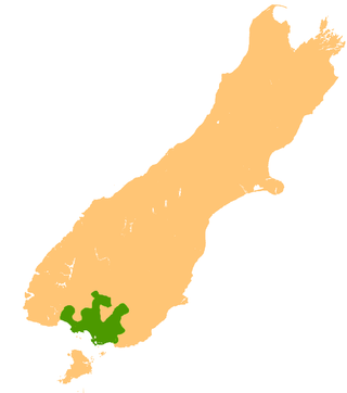
The Catlins comprise an area in the southeastern corner of the South Island of New Zealand. The area lies between Balclutha and Invercargill, straddling the boundary between the Otago and Southland regions. It includes the South Island's southernmost point, Slope Point.
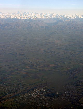
The Southland Plains is a general name given to several areas of low-lying land in the South Island of New Zealand, separated by the rise of the Hokonui Hills in the north. It forms a sizeable area of Southland region and encompasses its two principal settlements the city of Invercargill and the town of Gore. The Southland Plains include some of New Zealand's most fertile farmland.

The Tararua Range, often referred to as the Tararua Ranges or Tararua, is one of several mountain ranges in the North Island of New Zealand.

The Mount Lofty Ranges are a range of mountains in the Australian state of South Australia which for a small part of its length borders the east of Adelaide. The part of the range in the vicinity of Adelaide is called the Adelaide Hills and defines the eastern border of the Adelaide Plains.
The Catlins River Branch was a branch line railway that formed part of New Zealand's national rail network. It ran through the Catlins region in southwestern Otago and was built in sections between 1879 and 1915. It closed in 1971 except for the first four kilometres, which remain open as the Finegand Branch. Along the line was the Hunts Road tunnel, the southernmost tunnel in New Zealand.

The Catlins River flows southeastward through The Catlins, an area of the southern South Island of New Zealand. Its total length is 42 kilometres (26 mi), and it flows into the Pacific Ocean at the holiday settlement of Pounawea, 28 kilometres (17 mi) south of Balclutha. Its upper estuary is called Catlins Lake, and its lower estuary is shared with the Ōwaka River. The lower estuary is also known at Pounawea Estuary.
The Tahakopa River flows southeastward through the Catlins, an area of the southern South Island of New Zealand. Its total length is 32 kilometres (20 mi), and it flows into the Pacific Ocean 30 kilometres (19 mi) east of Waikawa, close to the settlement of Papatowai. The Maclennan River is a tributary.
The Mokoreta River is a river in Southland, New Zealand. A tributary of the Mataura River, its source is between Mt Rosebery and Catlins Cone, close to the source of the Catlins River. It flows westward from the Catlins Ranges into the Southland Plains. Its total length is 50 kilometres (31 mi), and it flows into the Mataura River about 5 kilometres (3 mi) south of the town of Wyndham.
Maclennan is a small settlement in The Catlins, an area of the southern South Island of New Zealand. It is located 20 kilometres southwest of Owaka. From 1915 until its closure on 27 February 1971, the Catlins River Branch railway passed through the village, and the station building and goods shed still stand today.
Mount Pye is a rugged hill in the southeast of the South Island of New Zealand. It is the highest point in the area known as the Catlins, rising to 720 m (2361 ft). It is located 40 km (25 mi) southeast of Gore, and forms part of the border between the Otago and Southland regions. The headwaters of many of the Catlins' rivers are located on the slopes of Mount Pye.
Mid Canterbury is a traditional, semi-official subregion of New Zealand's Canterbury Region extending inland from the Pacific coast to the Southern Alps. It is one of four traditional sub-regions of Canterbury, along with South Canterbury, North Canterbury, and Christchurch City.
The Fleming River is a river of the eastern Catlins, New Zealand. A tributary of the Tautuku River, it rises west of Soaker Hill in the Maclennan Range and flows south-eastward through the Catlins Forest Park to join that river at Tautuku.
The Tautuku River originates in the Maclennan Range of The Catlins in New Zealand. It continues through native bush for almost its entire length, including McLean Falls. Near its mouth at Tautuku Bay, just north of Tautuku Peninsula, the river flows through the Tautuku Estuary, a breeding ground for fernbirds.
The Waipati River, alternatively known as the Chaslands River is a river in the eastern Catlins, New Zealand. It rises in the Maclennan Range and flows south-eastward into the Waipati Beach north of Chaslands Mistake.
The small settlement of Caberfeidh is located in The Catlins, in the Otago region of New Zealand's South Island. The site of a former railway station on the Catlins Branch Line, it is sited close to a tributary of the Maclennan River, 5 kilometres north of the coast at Tahakopa Bay and 12 kilometres southwest of Owaka.

Ship Creek is a small river that flows into an area of coastal swamp forest on the West Coast of New Zealand's South Island. Ship Creek is approximately 11 km (6.8 mi) long and flows northwest from catchment areas on the slopes of Bald Hill, reaching the Tasman Sea around 20 km (12 mi) north-east of Haast. Near the mouth of Ship Creek, there are short walks around dune lakes and ancient kahikatea swamp forest.
References
- ↑ Reed, A. W. (2010). Peter Dowling (ed.). Place Names of New Zealand. Rosedale, North Shore: Raupo. p. 74. ISBN 9780143204107.