Related Research Articles

Canterbury is a region of New Zealand, located in the central-eastern South Island. The region covers an area of 44,503.88 square kilometres (17,183.04 sq mi), making it the largest region in the country by area. It is home to a population of 694,400.

The San Andreas Fault is a continental right-lateral strike-slip transform fault that extends roughly 1,200 kilometers (750 mi) through the U.S. state of California. It forms part of the tectonic boundary between the Pacific Plate and the North American Plate. Traditionally, for scientific purposes, the fault has been classified into three main segments, each with different characteristics and a different degree of earthquake risk. The average slip rate along the entire fault ranges from 20 to 35 mm per year.

Christchurch is the largest city in the South Island and the second-largest city by urban area population in New Zealand. Christchurch has an urban population of 415,100, and a metropolitan population of over half a million. It is located in the Canterbury Region, near the centre of the east coast of the South Island, east of the Canterbury Plains. It is located near the southern end of Pegasus Bay, and is bounded to the east by the Pacific Ocean and to the south by the ancient volcanic complex of the Banks Peninsula. The Avon River (Ōtākoro) winds through the centre of the city, with a large urban park along its banks. With the exception of the Port Hills, it is a relatively flat city, on an average around 20 m (66 ft) above sea level. Christchurch has a reputation for being an English city, with its architectural identity and nickname the 'Garden City' due to similarities with garden cities in England, but also has a historic Māori heritage. Christchurch has a temperate oceanic climate with regular moderate rainfall.

Cashmere is a suburb which rises above the southern end of the city of Christchurch in New Zealand's South Island, on the north side of the Port Hills. It covers an area of 4.71 km2 (1.82 sq mi) and has a population of 6,453 as at 2018.

Rolleston is the seat and largest town in the Selwyn District, in the Canterbury region of New Zealand's South Island. It is located on the Canterbury Plains 22 kilometres (14 mi) south-west of Christchurch, and is part of the wider Christchurch metropolitan area.
The Calaveras Fault is a major branch of the San Andreas Fault System that is located in northern California in the San Francisco Bay Area. Activity on the different segments of the fault includes moderate and large earthquakes as well as aseismic creep. The last large event was the magnitude 6.2 1984 Morgan Hill event. The most recent moderate earthquakes were the magnitude 5.1 event on 25 October 2022, and the magnitude 5.6 2007 Alum Rock event.

Loburn is a rural community in North Canterbury, New Zealand. It is located ten kilometres northwest of Rangiora and nearly 50 kilometres north of Christchurch.
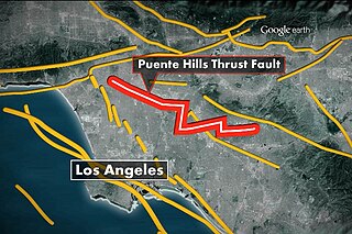
The Puente Hills Fault is an active geological fault that is located in the Los Angeles Basin in California. The thrust fault was discovered in 1999 and runs about 40 km (25 mi) in three discrete sections from the Puente Hills region in the southeast to just south of Griffith Park in the northwest. The fault is known as a blind thrust fault, as the fault plane does not extend to the surface. Large earthquakes on the fault are relatively infrequent but computer modeling has indicated that a major event could have substantial impact in the Los Angeles area. The fault is now thought to be responsible for one moderate earthquake in 1987 and another light event that took place in 2010, with the former causing considerable damage and deaths.

Canterbury in New Zealand is the portion of the South Island to the east of the Southern Alps / Kā Tiritiri o te Moana, from the Waiau Uwha River in the north, to the Waitaki River in the south.

Christchurch Central City or Christchurch City Centre is the geographical centre and the heart of Christchurch, New Zealand. It is defined as the area within the Four Avenues and thus includes the densely built up central city, some less dense surrounding areas of residential, educational and industrial usage, and green space including Hagley Park, the Christchurch Botanic Gardens and the Barbadoes Street Cemetery.

John Anderson was the second Mayor of Christchurch in New Zealand 1868–1869, and a successful businessman. He had a close connection with three buildings that have later received Category I heritage registrations by Heritage New Zealand. Two of these buildings were demolished following the February 2011 Christchurch earthquake.

The 1916 Irondale earthquake struck in the north–central region of the U.S. state of Alabama on October 18. The strongest earthquake in state history, it registered an estimated Richter scale magnitude of 5.1 and resulted in minor damage. Damage was limited to Shelby and Jefferson counties and reached its maximum severity near the epicenter in the city of Irondale, including cracked windows, fallen chimneys, and dried-up wells. While there were no fatalities, the earthquake spawned widespread panic, prompting alarmed workers to evacuate tall buildings.
The 2010 Canterbury earthquake struck the South Island of New Zealand with a moment magnitude of 7.1 at 4:35 am local time on 4 September, and had a maximum perceived intensity of X (Extreme) on the Mercalli intensity scale. Some damaging aftershocks followed the main event, the strongest of which was a magnitude 6.3 shock known as the Christchurch earthquake that occurred nearly six months later on 22 February 2011. Because this aftershock was centred very close to Christchurch, it was much more destructive and resulted in the deaths of 185 people.

Colombo Street is a main road of the city of Christchurch, New Zealand. It runs south-north through the centre of Christchurch with a break at Cathedral Square. As with many other central Christchurch streets, it is named for a colonial Anglican bishopric, Colombo, Sri Lanka in what at the time was known as Ceylon. Parts of the street which run through Sydenham were known as Addison Street during the 1880s, and some parts were known as Colombo Road.
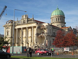
A major earthquake occurred in Christchurch on Tuesday 22 February 2011 at 12:51 p.m. local time. The Mw6.2 earthquake struck the Canterbury region in the South Island, centred 6.7 kilometres (4.2 mi) south-east of the central business district. It caused widespread damage across Christchurch, killing 185 people in New Zealand's fifth-deadliest disaster. Scientists classified it as an intraplate earthquake and potentially an aftershock of the 2010 Canterbury earthquake.
Ken Ring is a writer from Auckland, New Zealand, who asserts that he can use lunar cycles to predict weather and earthquakes. He terms his predictions "alternative weather" and has authored books about the weather and climate. Ring publishes almanacs each year for New Zealand, Australia and Ireland in which he provides weather predictions for the entire year. His New Zealand almanac covers 64 towns. Ring's methods have been shown to be unscientific and have been widely confirmed as fake and pseudoscience by many real scientists in the fields of meteorology and geology.

The June 2011 Christchurch earthquake was a shallow magnitude 6.0 Mw earthquake that occurred on 13 June 2011 at 14:20 NZST. It was centred at a depth of 7 km (4.3 mi), about 5 km (3 mi) south-east of Christchurch, which had previously been devastated by a magnitude 6.2 MW earthquake in February 2011. The June quake was preceded by a magnitude 5.9 ML tremor that struck the region at a slightly deeper 8.9 km (5.5 mi). The United States Geological Survey reported a magnitude of 6.0 Mw and a depth of 9 km (5.6 mi).

The Church of St Michael and All Angels is an Anglican church located at 84 Oxford Terrace, Christchurch, New Zealand.

City Mall is the main pedestrian mall in the central city of Christchurch, New Zealand, comprising two sections of Cashel Street plus the Bridge of Remembrance and one section of High Street. It is also known colloquially as Cashel Mall. The Bridge of Remembrance was pedestrianised in 1976. The main mall was closed to traffic on 11 January 1982 and formally reopened as a pedestrian mall on 7 August, but it was not until 1992 that the entire mall was paved. The mall was redeveloped between 2006 and 2009, and track was installed for an expansion of the heritage tram network.
The 1869 Christchurch earthquake occurred at 8:00 am on 5 June, near New Brighton, with an estimated Richter magnitude of 6.0. The shock had a Mercalli Intensity of VII–VIII.
References
- ↑ Gorman, Paul (29 March 2011). "Second Christchurch fault much better behaved". The Press . Retrieved 24 September 2011.
- ↑ "5 June 1869 Christchurch Earthquake" (PDF). GeoNet. February 2003. p. 5. Archived from the original (PDF) on 15 October 2011. Retrieved 20 October 2011.
| | This article about a regional geological feature is a stub. You can help Wikipedia by expanding it. |