Aotea / Great Barrier Local Board

Last updated • 2 min readFrom Wikipedia, The Free Encyclopedia

Aotea / Great Barrier Local Board
Te Poari ā-Rohe o Aotea
Great Barrier local board.svg
Country New Zealand
Region Auckland
Territorial authority Auckland Council
Ward Waitematā and Gulf Ward
Legislated2010
Local Board Members
Leadership
Chairperson
Izzy Fordham, Independent
Deputy chairperson
Chris Ollivier,Independent
Structure
Seats5
Political groups
  Independents (5)
Length of term
3 years
Elections
Last election
2022
Next election
2025
Meeting place
81 Hector Sanderson Road, Claris, Great Barrier Island

Aotea / Great Barrier Local Board is one of the 21 local boards of the Auckland Council, and is represented by the council's Waitematā and Gulf Ward councillor. [1]

Contents

The board's administrative area covers whole of the Great Barrier Island. [2]

The board is governed by five board members elected at-large. The inaugural members were elected in the nationwide 2010 local elections, coinciding with the introduction of the Auckland Council.

Demographics

Aotea/Great Barrier local board covers 320.28 km2 (123.66 sq mi) [3] and had an estimated population of 1,050 as of June 2023, [4] with a population density of 3.3 people per km2.

Historical population
YearPop.±% p.a.
2006894    
2013939+0.70%
2018936−0.06%
20231,251+5.97%
Source: [5] [6]
Ethnicities, 2023 Census
EthnicityPopulation
New Zealand European
1,122
Māori
285
Pasifika
27
Asian
21
MELAA
9
Other
18

Aotea/Great Barrier had a population of 1,251 in the 2023 New Zealand census, an increase of 315 people (33.7%) since the 2018 census, and an increase of 312 people (33.2%) since the 2013 census. There were 1,320 dwellings. The median age was 51.0 years (compared with 38.1 years nationally). There were 165 people (13.2%) aged under 15 years, 153 (12.2%) aged 15 to 29, 606 (48.4%) aged 30 to 64, and 324 (25.9%) aged 65 or older. [6]

Ethnicities were 89.7% European/Pākehā, 22.8% Māori, 2.2% Pasifika, 1.7% Asian, 0.7% Middle Eastern, Latin American and African New Zealanders, and 1.4% other. People may identify with more than one ethnicity. [6]

The Local Board Area had a population of 936 at the 2018 New Zealand census. There were 537 households, comprising 507 males and 429 females, giving a sex ratio of 1.18 males per female.

The percentage of people born overseas was 18.3, compared with 27.1% nationally.

Although some people chose not to answer the census's question about religious affiliation, 62.5% had no religion, 24.7% were Christian, 1.3% had Māori religious beliefs, 1.0% were Buddhist and 1.6% had other religions.

Of those at least 15 years old, 144 (18.0%) people had a bachelor's or higher degree, and 147 (18.4%) people had no formal qualifications. The median income was $21,200, compared with $31,800 nationally. 48 people (6.0%) earned over $70,000 compared to 17.2% nationally. The employment status of those at least 15 was that 282 (35.3%) people were employed full-time, 168 (21.1%) were part-time, and 57 (7.1%) were unemployed. [5]

2022-25 term

The board's term currently runs from the 2022 Local Body Elections to the local body elections in 2025. The current board members are: [7]

Izzy Fordham (Chair), Independent
Patrick O'Shea (Deputy Chair), Independent
Neil Sanderson, Independent
Chris Ollivier, Independent
Laura Caine, None

Related Research Articles

<span class="mw-page-title-main">Rodney ward</span> Ward of Auckland in New Zealand

Rodney Ward is a local government area in the northernmost part of New Zealand's Auckland Region, created along with the Auckland Council in 2010. The area was previously part of Rodney District; it does not include the Hibiscus Coast, which was also part of Rodney District but is now in Albany ward. The Rodney Local Board area has the same boundaries as Rodney Ward.

<span class="mw-page-title-main">Waitematā Local Board</span> Local board of Waitematā in Auckland, New Zealand

The Waitematā Local Board is one of the 21 local boards of the Auckland Council, and is one of the three boards overseen by the council's Waitematā and Gulf Ward councillor.

<span class="mw-page-title-main">Puketāpapa Local Board</span> Local board of Puketāpapa in Auckland, New Zealand

The Puketāpapa Local Board is one of the 21 local boards of the Auckland Council, and is one of the two boards overseen by the council's Albert-Eden-Puketāpapa ward councilors.

<span class="mw-page-title-main">Ōrākei ward</span> Ward of Auckland in New Zealand

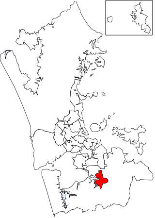
Ōrākei Ward is one of thirteen wards of Auckland Council in Auckland, New Zealand. It encompasses the neighbourhoods of Saint Heliers, Glendowie, Kohimarama, Mission Bay, Saint Johns and Meadowbank. It elects one councillor to represent the ward on the council. The councillor has oversight over the Orakei Local Board. The current councillor is Desley Simpson.

<span class="mw-page-title-main">Franklin ward</span> Ward of Auckland in New Zealand

The Franklin Ward is the southernmost ward on the Auckland Council. The Franklin ward has one local board, also called Franklin; the Franklin Local Board has three subdivisions - Wairoa, Pukekohe and Waiuku. Franklin is currently represented by Andy Baker.

<span class="mw-page-title-main">Devonport-Takapuna Local Board</span> Auckland Council Local Board

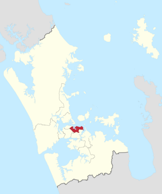
The Devonport-Takapuna Local Board covers from Castor Bay and Sunnynook south to the end of the Devonport Peninsula; it is separated from the Kaipātiki board area by the Northern Motorway. This local board sits in the Auckland Council office buildings on The Strand in Takapuna. These were the North Shore City Council offices until the North Shore City Council was merged into Auckland Council in 2010. It is part of the North Shore Ward of Auckland Council, which also includes the Kaipātiki Local Board.

<span class="mw-page-title-main">Kaipātiki Local Board</span> Local board of Auckland Council in New Zealand

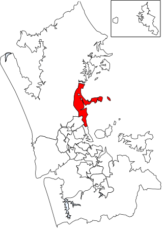
The Kaipātiki Local Board is one of the 21 local boards of Auckland Council, and is one of the two boards overseen by the council's North Shore Ward councillors. It covers Glenfield south to Northcote Point. Its eastern border is the Northern Motorway and its western border is the Waitematā Harbour. The board sits at the Citizen's Advice Bureau in Bentley Ave, Glenfield. AUT's Akoranga Campus is the only tertiary institution in the North Shore ward, and it is in the Kaipātiki board area.

<span class="mw-page-title-main">Howick ward</span> Ward of Auckland in New Zealand

Howick Ward is an Auckland Council ward which elects two councillors and covers the Howick Local Board. Sharon Stewart and Maurice Williamson are the current councillors.

<span class="mw-page-title-main">Manurewa-Papakura ward</span> Ward of Auckland in New Zealand

Manurewa-Papakura Ward is an Auckland Council ward which elects two councillors and covers the Manurewa and Papakura Local Boards. The two councillors are currently Angela Dalton and Daniel Newman.

<span class="mw-page-title-main">Waitematā and Gulf ward</span> Ward of Auckland in New Zealand

Waitematā and Gulf Ward is an Auckland Council ward which elects one councillor and covers the Great Barrier, Waiheke, and Waitematā Local Boards. The current councillor is Mike Lee.

<span class="mw-page-title-main">Whau ward</span> Ward of Auckland in New Zealand

Whau Ward is an Auckland Council ward which elects one councillor and covers the Whau local board area. The current councillor is Kerrin Leoni.

<span class="mw-page-title-main">Hibiscus and Bays Local Board</span> Local board of Auckland Council in New Zealand

The Hibiscus and Bays Local Board is one of the 21 local boards of the Auckland Council. It is one of two boards overseen by the council's Albany Ward councillors. The board consists of eight members elected at large.

<span class="mw-page-title-main">Upper Harbour Local Board</span> Local board of Auckland Council in New Zealand

The Upper Harbour Local Board is one of the 21 local boards of the Auckland Council, and is one of the two boards overseen by the council's Albany Ward councillors.

<span class="mw-page-title-main">Māngere-Ōtāhuhu Local Board</span> Local board of Auckland Council in New Zealand

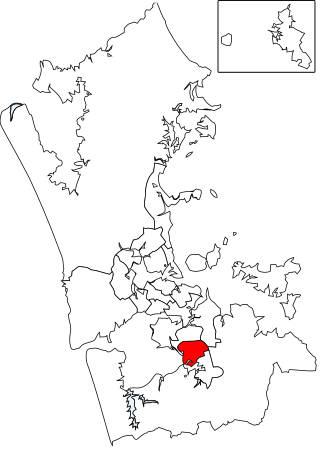
Māngere-Ōtāhuhu Local Board is one of the 21 local boards of the Auckland Council, and is overseen by the council's Manukau ward councillors. The board is governed by seven board members elected at-large. The board's administrative area includes the suburbs Māngere Bridge, Māngere, Ōtāhuhu, and Favona, and covers areas south of the Manukau Harbour.

<span class="mw-page-title-main">Henderson-Massey Local Board</span> Local board of Auckland Council in New Zealand

Henderson-Massey Local Board is one of the 21 local boards of the Auckland Council, and is overseen by the council's Waitākere Ward councillors.

<span class="mw-page-title-main">Waiheke Local Board</span> Local board of Waiheke Island in Auckland, New Zealand

The Waiheke Local Board is one of the 21 local boards of the Auckland Council. It is one of three local board areas overseen by the Waitematā and Gulf Ward councillor.

<span class="mw-page-title-main">Papakura Local Board</span> Local board of Papakura in Auckland, New Zealand

The Papakura Local Board is one of the 21 local boards of the Auckland Council. It is overseen by the Manurewa-Papakura ward councillor.

<span class="mw-page-title-main">Manurewa Local Board</span> Local board of Manurewa in Auckland, New Zealand

The Manurewa Local Board is one of the 21 local boards of the Auckland Council. It is overseen by the Manurewa-Papakura ward councillor.

<span class="mw-page-title-main">Tryphena, New Zealand</span> Place in Auckland Region, New Zealand

Tryphena is a beach settlement on the southern coast of Great Barrier Island in the Hauraki Gulf of New Zealand's Auckland Region.

<span class="mw-page-title-main">Shelly Beach, New Zealand</span> Place in Auckland Region, New Zealand

Shelly Beach, officially known as Aotea / Shelly Beach, is a settlement and beach located on the eastern side of Te Korowai-o-Te-Tonga Peninsula and the southwest side of Kaipara Harbour, North Auckland. In 2018, a seawall and five groynes were constructed to fight erosion.

References

  1. "Waitematā and Gulf Ward - Rohe o Waitematā me te Whanga o Hauraki". Auckland Council. Retrieved 18 April 2020.
  2. "About Great Barrier". 27 October 2018. Retrieved 27 October 2018.
  3. "ArcGIS Web Application". statsnz.maps.arcgis.com. Retrieved 3 June 2024.
  4. "Subnational population estimates (RC, SA2), by age and sex, at 30 June 1996-2023 (2023 boundaries)". Statistics New Zealand . Retrieved 25 October 2023. (regional councils); "Subnational population estimates (TA, SA2), by age and sex, at 30 June 1996-2023 (2023 boundaries)". Statistics New Zealand . Retrieved 25 October 2023. (territorial authorities); "Subnational population estimates (urban rural), by age and sex, at 30 June 1996-2023 (2023 boundaries)". Statistics New Zealand . Retrieved 25 October 2023. (urban areas)
  5. 1 2 "Statistical area 1 dataset for 2018 Census". Statistics New Zealand. March 2020. Great Barrier Local Board Area (CMB07608). 2018 Census place summary: Great Barrier Local Board Area
  6. 1 2 3 "2023 Census national and subnational usually resident population counts and dwelling counts" (Microsoft Excel). Stats NZ - Tatauranga Aotearoa. Retrieved 29 May 2024.
  7. "Local Elections 2022 Official Results Local Board Members" (PDF). Auckland Council. Retrieved 4 March 2024.

36°14′37″S175°28′01″E / 36.243632114°S 175.46681535°E / -36.243632114; 175.46681535