Franklin ward

Last updated

Franklin Ward
Auckland Council Franklin Ward.png
Country New Zealand
Island North Island
Region Auckland Region
Area
[1]
  Land1,199.75 km2 (463.23 sq mi)
Population
 (June 2022) [2]
  Total83,600

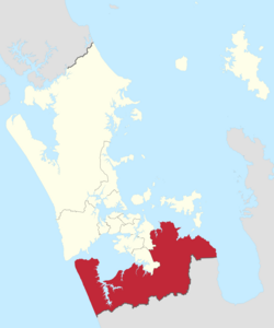
The Franklin Ward is the southernmost ward on the Auckland Council. The Franklin ward has one local board, also called Franklin; the Franklin Local Board has three subdivisions - Wairoa, Pukekohe and Waiuku. [3] Franklin is currently represented by Andy Baker.

Contents

Demographics

Franklin ward covers 1,199.75 km2 (463.23 sq mi) [1] and had an estimated population of 83,600 as of June 2022, [2] with a population density of 70 people per km2.

Historical population
YearPop.±% p.a.
200658,605    
201365,319+1.56%
201874,838+2.76%
Source: [4]

Franklin ward had a population of 74,838 at the 2018 New Zealand census, an increase of 9,519 people (14.6%) since the 2013 census, and an increase of 16,233 people (27.7%) since the 2006 census. There were 25,359 households, comprising 37,155 males and 37,683 females, giving a sex ratio of 0.99 males per female. The median age was 40.5 years (compared with 37.4 years nationally), with 15,765 people (21.1%) aged under 15 years, 12,882 (17.2%) aged 15 to 29, 34,896 (46.6%) aged 30 to 64, and 11,295 (15.1%) aged 65 or older.

Ethnicities were 82.0% European/Pākehā, 15.0% Māori, 5.4% Pacific peoples, 8.5% Asian, and 2.1% other ethnicities. People may identify with more than one ethnicity.

The percentage of people born overseas was 22.3, compared with 27.1% nationally.

Although some people chose not to answer the census's question about religious affiliation, 51.9% had no religion, 35.2% were Christian, 0.9% had Māori religious beliefs, 1.6% were Hindu, 0.7% were Muslim, 0.5% were Buddhist and 2.4% had other religions.

Of those at least 15 years old, 11,064 (18.7%) people had a bachelor's or higher degree, and 10,431 (17.7%) people had no formal qualifications. The median income was $38,200, compared with $31,800 nationally. 14,364 people (24.3%) earned over $70,000 compared to 17.2% nationally. The employment status of those at least 15 was that 31,635 (53.6%) people were employed full-time, 8,706 (14.7%) were part-time, and 1,941 (3.3%) were unemployed. [4]

Councillors

Franklin Ward Councillor of Auckland
Incumbent
Andy Baker
since 2022
Term length Three years
Inaugural holder Des Morrison
Formation1 November 2010
Website www.aucklandcouncil.govt.nz
ElectionCouncillor electedAffiliationVotesNotes
2010 Des Morrison C&R Team Franklin 10,651
2013 Bill Cashmore C&R Team Franklin 8,178
2016 [5] Bill CashmoreTeam Franklinelected unopposed [6] Appointed Deputy Mayor of Auckland by mayor Phil Goff after Goff won the 2016 Auckland mayoral election.
2019 Bill CashmoreTeam Franklinelected unopposed [7]
2022 Andy Baker Team Franklin14,187 [8]

Election Results

Election Results for the Franklin Ward:

2022 Election Results

NameAffiliationVotes
1 Andy Baker Team Franklin14187
Keven Mealamu Independent9279
Blank820
Informal10

[8]


Related Research Articles

<span class="mw-page-title-main">Rodney ward</span> Ward of Auckland in New Zealand

Rodney Ward is a local government area in the northernmost part of New Zealand's Auckland Region, created along with the Auckland Council in 2010. The area was previously part of Rodney District; it does not include the Hibiscus Coast, which was also part of Rodney District but is now in Albany ward. The Rodney Local Board area has the same boundaries as Rodney Ward.

<span class="mw-page-title-main">Waitematā Local Board</span> Local board of Auckland Council in New Zealand

The Waitematā Local Board is one of the 21 local boards of the Auckland Council, and is one of the three boards overseen by the council's Waitematā and Gulf Ward councillor.

<span class="mw-page-title-main">Waitākere ward</span> Ward of Auckland in New Zealand

Waitākere Ward is a district of Auckland Council in New Zealand. It consists of the part of the old Waitakere City lying west of a line from Te Atatū Peninsula to Titirangi.

<span class="mw-page-title-main">Ōrākei ward</span> Ward of Auckland in New Zealand

Ōrākei Ward is one of thirteen wards of Auckland Council in Auckland, New Zealand. It encompasses the neighbourhoods of Saint Heliers, Glendowie, Kohimarama, Mission Bay, Saint Johns and Meadowbank. It elects one councillor to represent the ward on the council. The councillor has oversight over the Orakei Local Board. The current councillor is Desley Simpson.

<span class="mw-page-title-main">North Shore ward</span> Ward of Auckland in New Zealand

North Shore Ward is an Auckland Council ward that elects two councillors and covers the Devonport-Takapuna and Kaipātiki Local Boards. The two councillors are currently Richard Hills and Chris Darby.

<span class="mw-page-title-main">Albert-Eden-Puketāpapa ward</span> Ward of Auckland in New Zealand

The Albert-Eden-Puketāpapa Ward is an Auckland Council ward which elects two councillors and covers the Albert-Eden and Puketāpapa Local Boards. Currently the councillors are Christine Fletcher and Julie Fairey. Prior to 2019, this ward was known as the Albert-Eden-Roskill Ward.

<span class="mw-page-title-main">Devonport-Takapuna Local Board</span> Local board of Auckland Council in New Zealand

The Devonport-Takapuna Local Board covers from Castor Bay, and Sunnynook south to the end of the Devonport Peninsula; it is separated from the Kaipātiki board area by the Northern Motorway. This local board sits in the Auckland Council office buildings on The Strand in Takapuna. These were the North Shore City Council offices until the North Shore City Council was merged into Auckland Council in 2010. It is part of the North Shore Ward of Auckland Council, which also includes the Kaipātiki Local Board.

<span class="mw-page-title-main">Kaipātiki Local Board</span> Local board of Auckland Council in New Zealand

The Kaipātiki Local Board is one of the 21 local boards of Auckland Council, and is one of the two boards overseen by the council's North Shore Ward councillors. It covers Glenfield south to Northcote Point. Its eastern border is the Northern Motorway and its western border is the Waitematā Harbour. The board sits at the Citizen's Advice Bureau in Bentley Ave, Glenfield. AUT's Akoranga Campus is the only tertiary institution in the North Shore ward, and it is in the Kaipātiki board area.

<span class="mw-page-title-main">Albany ward (local government)</span> Ward of Auckland in New Zealand

Albany Ward is an Auckland Council ward which elects two councillors and covers the Hibiscus and Bays and Upper Harbour Local Boards. The two councillors are currently John Watson and Wayne Walker.

<span class="mw-page-title-main">Howick ward</span> Ward of Auckland in New Zealand

Howick Ward is an Auckland Council ward which elects two councillors and covers the Howick Local Board. Sharon Stewart and Maurice Williamson are the current councillors.

<span class="mw-page-title-main">Manukau ward</span> Ward of Auckland in New Zealand

Manukau Ward is an Auckland Council ward that elects two councillors and covers the Māngere-Ōtāhuhu and Ōtara-Papatoetoe Local Boards. The two councillors are currently Alf Filipaina and Lotu Fuli.

<span class="mw-page-title-main">Manurewa-Papakura ward</span> Ward of Auckland in New Zealand

Manurewa-Papakura Ward is an Auckland Council ward which elects two councillors and covers the Manurewa and Papakura Local Boards. The two councillors are currently Angela Dalton and Daniel Newman.

<span class="mw-page-title-main">Maungakiekie-Tāmaki ward</span> Ward of Auckland in New Zealand

Maungakiekie-Tāmaki Ward is an Auckland Council ward which elects one councillor and covers the Maungakiekie-Tāmaki Local Board. The current councillor is Josephine Bartley.

<span class="mw-page-title-main">Waitematā and Gulf ward</span> Ward of Auckland in New Zealand

Waitematā and Gulf Ward is an Auckland Council ward which elects one councillor and covers the Great Barrier, Waiheke, and Waitematā Local Boards. The current councillor is Mike Lee.

<span class="mw-page-title-main">Whau ward</span> Ward of Auckland in New Zealand

Whau Ward is an Auckland Council ward which elects one councillor and covers the Whau local board area. The current councillor is Kerrin Leoni.

<span class="mw-page-title-main">Upper Harbour Local Board</span> Local board of Auckland Council in New Zealand

The Upper Harbour Local Board is one of the 21 local boards of the Auckland Council, and is one of the two boards overseen by the council's Albany Ward councillors.

<span class="mw-page-title-main">Māngere-Ōtāhuhu Local Board</span> Local board of Auckland Council in New Zealand

Māngere-Ōtāhuhu Local Board is one of the 21 local boards of the Auckland Council, and is overseen by the council's Manukau ward councillors. The board is governed by seven board members elected at-large. The board's administrative area includes the suburbs Māngere Bridge, Māngere, Ōtāhuhu, and Favona, and covers areas south of the Manukau Harbour.

<span class="mw-page-title-main">Waitākere Ranges Local Board</span> Local board of Auckland Council in New Zealand

Waitākere Ranges Local Board is one of the 21 local boards of the Auckland Council, and is one of the two boards overseen by the council's Waitākere Ward councillors.

<span class="mw-page-title-main">Papakura Local Board</span> Local board of Auckland Council in New Zealand

The Papakura Local Board is one of the 21 local boards of the Auckland Council. It is overseen by the Manurewa-Papakura ward councillor.

The Ōtara-Papatoetoe Local Board is one of the 21 local boards of the Auckland Council. It is overseen by the Manukau ward councillors.

References

  1. 1 2 "ArcGIS Web Application". statsnz.maps.arcgis.com. Retrieved 24 February 2022.
  2. 1 2 "Subnational population estimates (RC, SA2), by age and sex, at 30 June 1996-2022 (2022 boundaries)". Statistics New Zealand . Retrieved 25 October 2022. (regional councils); "Subnational population estimates (TA, SA2), by age and sex, at 30 June 1996-2022 (2022 boundaries)". Statistics New Zealand . Retrieved 25 October 2022. (territorial authorities); "Subnational population estimates (urban rural), by age and sex, at 30 June 1996-2022 (2022 boundaries)". Statistics New Zealand . Retrieved 25 October 2022. (urban areas)
  3. "Franklin ward". www.aucklandcouncil.govt.nz. Retrieved 3 January 2017.
  4. 1 2 "Statistical area 1 dataset for 2018 Census". Statistics New Zealand. March 2020. Franklin Ward (07613).
  5. "Local body election nominations close". Radio New Zealand. 12 August 2016. Retrieved 3 January 2017.
  6. "Ward councillors – Franklin Ward confirmed" (PDF). Auckland Council. 2016. Retrieved 9 December 2017.
  7. "Auckland local board election results: Some wards too close to call". Stuff.co.nz. 12 October 2019. Retrieved 18 October 2019.
  8. 1 2 "Local Elections 2022 - Official Results" (PDF). Auckland Council. 15 October 2022. Archived (PDF) from the original on 17 October 2022. Retrieved 17 October 2022.