This article is about the former local government area of the central portion of the Auckland urban area. For the football club, see Auckland City FC. For the 19th-century parliamentary constituency, see City of Auckland (New Zealand electorate). For the central Auckland area, see Auckland isthmus. For the wider urban area, see Auckland.
Former territorial authority area of New Zealand in Auckland
Auckland City's urban areas (in orange) within the greater Auckland urban region (grey). The city centre is ringed. Auckland City also encompassed islands of the inner (upper right) and outer Hauraki Gulf.
The territory of Auckland grew from just covering the central business district to encompass suburbs such as Ponsonby and Parnell, although several suburbs remained independent boroughs until the 1989 local government reforms, when the nascent Auckland City was constituted as covering the entire isthmus and islands within the Hauraki Gulf such as Waiheke.
City of Auckland (1871–1989)
History
Auckland was constituted a city On 24 April 1871 under The Municipal Corporations Act, 1867 by Parliament.[2]:80 Previously Auckland was an independent borough.[2]:74
The boundaries of Auckland were Stanley Street, Symonds Street, Karangahape Road, Ponsonby Road, and Franklin Road. It was initially 623 acres (252ha) in size. In 1882 it more than doubled in size by amalgamating the neighbouring highway districts of Ponsonby, Karangahape, and Grafton. The boundaries remained static until a period of multiple amalgamations between 1913 and 1921 resulted in an increase to 7,844 acres (3,174ha), an almost five-fold increase. These amalgamations were: 15 February 1913, Parnell Borough; 1 April 1913, Arch Hill Road District; 1 July 1914, Grey Lynn Borough; 1 March 1915, Remuera Road District; 1 October 1915, Eden Terrace Road District; 1 February 1917, Epsom Road District; 1 April 1918 188 acres (76ha) from West Tamaki Road District, to incorporate lake St John; 1 March 1921; 1 March 1921, Point Chevalier Road District.[2]:145[3]:109–110 Further amalgamations included Avondale Borough in 1 September 1927, West Tamaki and Orakei Road District in 1 April 1928.[3]:110 From 1928 to 1971 the city did not change boundaries except for harbour reclamations and the inclusion of the Auckland Domain and the loss of 9 acres (3.6ha) to the Newmarket Borough.[3]:66,113 By this point the city covered 18,500 acres (7,500ha).[3]:109
By 1971 the city stretched from the Whau River in the West to the Tamaki River in the East; however, the city did not cover the entire Auckland isthmus due to the existence of several independent boroughs.[4]
Wards
The City of Auckland used wards for electoral purposes from 1878 to 1903. Initially the city had three wards: East, West, and North, after the amalgamation of Ponsonby, Karangahape, and Grafton these districts were included as wards. In 1901 the Karangahape ward was abolished as the Municipal Corporations Act 1900 imposed a limit of 5 wards.[3]:109–110
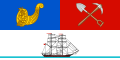
The ship is intended to symbolise Auckland City's relationship with the sea as a major port, while the cornucopia symbolises agricultural productivity and the pick and shovel symbolise early mining activities in the Auckland Province.
Auckland City (1989–2010)
Geography
The mainland part of Auckland City occupied the Auckland isthmus, also known as the Tāmaki isthmus. The Waitematā Harbour, which opens to the Hauraki Gulf, separated North Shore City from the isthmus. The Manukau Harbour, which opens to the Tasman Sea, separated Manukau City from the isthmus. The distance between the two harbours is particularly narrow at each end of the isthmus. At the western end, the Whau River, an estuarial arm of the Waitematā Harbour, comes within two kilometres of the waters of the Manukau Harbour on the west coast and marks the beginning of the Northland Peninsula. A few kilometres to the southeast at Ōtāhuhu, the Tāmaki River, an arm of the Hauraki Gulf on the east coast, comes just 1200 metres from the Manukau's waters. Being part of the Auckland volcanic field, much of the isthmus is mantled with volcanic rocks and soils, and several prominent scoria cones dot the isthmus.
In November 1989, central government restructured local authorities throughout New Zealand. After substantial protests and legal challenges, Auckland City was merged with eight smaller local authorities to form a new Auckland City Council. The new Auckland City had double the population of the old. However, amalgamation, forced onto local authorities often against their will, was criticised to have led to less democracy and higher rates for the same services.[8]
Auckland City was the most populous local authority in the country, with a population of 450,300 at 30 June 2010.[9] In 2010 it was made up of 188 ethnic groups, making it New Zealand's most diverse city, and slightly more diverse than in 2007, when 185 ethnic groups had been counted.[10][11] In 2010, the life expectancy was 83 years for women, and 79.6 years for men, while the average age of the population was 33.4 years, with 35.9 years for the whole country.[10]
In 2009, Auckland was rated the fourth-best place to live in the world, in human resources consultancy Mercer's annual survey.[12]
Economy
In the year to March 2009, Auckland City had 353,000 jobs, of which 26.3% was held by property and business services,[13] as well as 65,655 businesses, making up 13.1% of New Zealand's businesses and 16.2% of New Zealand's jobs.[14] Over 2009 to the month of March, Auckland City's unemployment rate increased to 5.6%, compared to the overall New Zealand unemployment rate of 4.5%. In addition the city's economic output declined by 2.4%.[13] Gareth Stiven, the economic manager of Auckland City, stated that this was because the city's economy was heavily involved with service industries, such as banking and insurance, which were affected by financial crises.[15] However, over the last five years of its existence, Auckland's economic growth averaged 1.4% each year, higher than the average of the region and the nation.[10]
Air New Zealand has its worldwide headquarters, called "The Hub", off Beaumont and Fanshawe Streets in the Western Reclamation;[17][18] the airline moved there from the Auckland CBD in 2006.[17] In September 2003 Air New Zealand was the only one of the very largest corporations in New Zealand to have its headquarters within the Auckland CBD.[16]
Administrative divisions
Auckland City was divided into seven wards; each of them consisting of the following areas, that were arranged electorally, starting from the west:[a]
↑ Otherwise known as Auckland Central or Auckland CBD.
Sister cities and friendship cities
Auckland City had six sister cities and two friendship city relationships.[19] All of these cities except Hamburg (Germany) and Galway (Ireland) are located around the Pacific Rim.[20]
1 2 3 4 5 Bloomfield, Gerald Taylor (1973). The Evolution of Local Government Areas in Metropolitan Auckland, 1840-1971. Auckland: [Auckland]: Auckland University Press. ISBN0-19-647714-X.{{cite book}}: CS1 maint: publisher location (link)
↑ Laurenson, Helen (1 May 2019). The History of Mt Eden - The District and its People. Epsom & Eden District Historical Society. p.64. ISBN9780473460013.
↑ Thorns, David; Schrader, Ben. "City history and people – Towns to cities". teara.govt.nz. New Zealand Ministry for Culture and Heritage Te Manatu Taonga. Retrieved 29 December 2022.
↑ McLintock, Alexander Hare. "Coats of Arms – Local". An encyclopaedia of New Zealand, edited by A. H. McLintock, 1966. New Zealand Ministry for Culture and Heritage Te Manatu Taonga. Retrieved 29 December 2022.
This page is based on this Wikipedia article Text is available under the CC BY-SA 4.0 license; additional terms may apply. Images, videos and audio are available under their respective licenses.