Related Research Articles
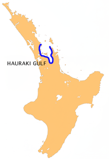
The Hauraki Gulf / Tīkapa Moana is a coastal feature of the North Island of New Zealand. It has an area of 4000 km2, and lies between, in anticlockwise order, the Auckland Region, the Hauraki Plains, the Coromandel Peninsula, and Great Barrier Island. Most of the gulf is part of the Hauraki Gulf Marine Park.
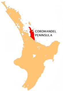
The Coromandel Peninsula on the North Island of New Zealand extends 85 kilometres (53 mi) north from the western end of the Bay of Plenty, forming a natural barrier protecting the Hauraki Gulf and the Firth of Thames in the west from the Pacific Ocean to the east. It is 40 kilometres (25 mi) wide at its broadest point. Almost its entire population lies on the narrow coastal strips fronting the Hauraki Gulf and the Bay of Plenty. In clear weather the peninsula is clearly visible from Auckland, the country's biggest city, which lies on the far shore of the Hauraki Gulf, 55 kilometres (34 mi) to the west. The peninsula is part of the Thames-Coromandel District of the Waikato region.
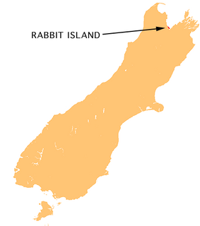
Moturoa / Rabbit Island is a small island that lies across the southernmost part of Tasman Bay / Te Tai-o-Aorere, on the northern coast of New Zealand's South Island. The long narrow island runs east–west for 8 kilometres (5 mi), and covers 15 km2 (5.8 sq mi).

Cape Colville is the northernmost point of the Coromandel Peninsula in New Zealand's North Island. It lies 85 kilometres north of Thames, and 70 kilometres northeast of the city of Auckland, on the other side of the Hauraki Gulf. The small settlements of Port Jackson and Fletcher Bay lie immediately to the west and east respectively of the cape.

The Colville Channel is one of three channels connecting the Hauraki Gulf with the Pacific Ocean to the northeast of Auckland, New Zealand. It is the easternmost channel, lying between the southern end of Great Barrier Island and Cape Colville at the northern tip of the Coromandel Peninsula. The tiny Channel Island lies in the centre of the channel.

Rangipo Desert is a barren desert-like environment in New Zealand, located in the Ruapehu District on the North Island Volcanic Plateau; to the east of the three active peaks of Mount Tongariro, Mount Ngauruhoe, and Mount Ruapehu, and to the west of the Kaimanawa Range.
Kaikoura Island lies in an irregularly-shaped bay on the western side of Great Barrier Island in the Hauraki Gulf in New Zealand, 90 km (56 mi) north east of Auckland. Kaikoura Island is the seventh largest island in the Hauraki Gulf. It is 80 metres from Great Barrier Island at its closest point and forms the natural harbours of Port FitzRoy and Port Abercrombie. Its biota includes the endangered brown teal duck, the North Island kaka and many native trees and shrubs.

Windy Canyon is a canyon and associated walking track on Great Barrier Island, New Zealand. Located in the centre east of the island, the canyon is a wind funnel shaped from andesitic rock. The canyon is located on one of the highest stretches of the island, less than 200 m below the 621 m summit of Mount Hobson. From the canyon it is possible to view the Okiwi and Awana lowlands.
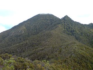
Mount Hobson is the highest mountain on Great Barrier Island, New Zealand. Located in the centre of the island, it rises 627 m (2,057 ft) above sea level.
Port Fitzroy is a harbour and coastal community on Great Barrier Island in New Zealand's Hauraki Gulf.

Harataonga is a beach and bay on the northeast coast of Great Barrier Island in New Zealand's Hauraki Gulf. It is located approximately 51 nautical miles northeast of central Auckland, and is also known as Overtons Beach.
Okiwi Airfield, also called Okiwi Station Airfield, is a small airfield located near the village of Okiwi on Great Barrier Island. It has a single bitumen runway, and a small terminal in the form of a wooden hut. The airfield is owned by Auckland Council and is used for both general aviation and on-demand commercial flights operated by Fly My Sky.
Kaitoke Beach is a beach and settlement on Great Barrier Island in the Hauraki Gulf of Auckland, New Zealand.
Medlands Beach is a beach settlement, located in Oruawharo Bay on Great Barrier Island in the Hauraki Gulf of Auckland, New Zealand.
Claris is the largest settlement on Great Barrier Island in the Hauraki Gulf of Auckland, New Zealand. It includes Great Barrier Aerodrome, the major entry and exit point to the island.
Awana Bay is a beach on the east coast of Great Barrier Island in the Hauraki Gulf of New Zealand's Auckland Region.
Tryphena is a beach settlement on the southern coast of Great Barrier Island in the Hauraki Gulf of New Zealand's Auckland Region.
Okiwi is a settlement and rural community on Great Barrier Island in New Zealand's Hauraki Gulf. It is located at the head of the Whangapoua Estuary, in Whangapoua Bay.
Whangapoua Beach is a beach on the east coast of Great Barrier Island in New Zealand's Hauraki Gulf.
Whangaparapara is a habour and coastal community on Great Barrier Island in New Zealand's Hauraki Gulf.
References
- ↑ "Palmer's Beach". greatbarrierphotography.com. Great Barrier Photography.
- ↑ "Palmers". surfseeker.nz. Surf Seeker NZ.
- ↑ "Palmers Beach". greatbarrierisland.nz. Destination Great Barrier Island.
Coordinates: 36°13′34″S175°28′34″E / 36.2262358°S 175.4761353°E