
Horowhenua District is a local government district on the west coast of the North Island of New Zealand. It forms part of the Manawatū-Whanganui region. Its name roughly means shaking or rippling earth.
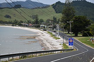
Hikuai is a small community on the Tairua River towards the base of the Coromandel Peninsula in the North Island of New Zealand. It lies 40 kilometres north of Waihi and 10 kilometres southwest of Tairua, close to the junction of State Highways 25 and 25A, the latter of which is a winding road cutting across the steep Coromandel Range of hills. It is a tourist hot spot in days such as New Zealand Labour Weekend, The Christmas Holidays and especially when Tairua and Pauanui are busy.
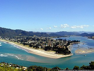
The town of Pauanui is on the east coast of the Coromandel Peninsula in the North Island of New Zealand. It lies at the mouth of the Tairua River on its south bank, directly opposite the larger town of Tairua.

The town of Whangamatā is sited on the southeast coast of the Coromandel Peninsula in the North Island of New Zealand. It is located 30 kilometres north of Waihi, to the north of the western extremity of the Bay of Plenty.
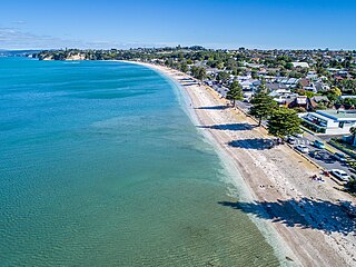
Eastern Beach is a suburb of Auckland, New Zealand. Located on the eastern city of the city centre, the suburb is in the Howick ward, one of the thirteen administrative divisions of Auckland City.

Oneroa is a settlement on Waiheke Island in northern New Zealand. It was known as the capital city of the island.

Ostend is a settlement on Waiheke Island, in New Zealand's Hauraki Gulf within the Auckland Region. Ostend is located in the west of the island, on and around a small peninsula which juts into Putiki Bay, one of two large indentations in the island's southwest coast. The southwest of the island contains much of the island's population, with Ostend being located immediately to the east of the settlement of Surfdale, and to the southwest of Onetangi.

Maraetai is a town in the former Manukau City and the easternmost suburb of greater Auckland in New Zealand.

Matatoki is a locality on the Hauraki Plains of New Zealand. It lies on State Highway 26, south east of Thames and north of Paeroa. The Matatoki Stream runs from the Coromandel Range through the area to join the Waihou River.
Te Rerenga is a locality on the Whangapoua Harbour, Coromandel Peninsula, New Zealand. State Highway 25 runs through it. Coromandel is 12 km to the west. Whitianga lies to the south east. The Waitekuri and Opitonui Rivers flow from the Coromandel Range in the west and south through the area to drain in the Whangapoua Harbour.
Whenuakite is a locality on the Coromandel Peninsula of New Zealand. State Highway 25 runs through it. Whitianga is north west, Coroglen 8 km west, Cooks Beach and Hahei north, Hot Water Beach north east, and Tairua 18 km to the south east. The Whenuakite River flows from coastal hills in the east through the area to drain in the Whitianga Harbour.

Long Bay is a northern suburb of the North Shore, part of the Auckland metropolitan area in New Zealand.

The Pines Beach is a small town situated roughly 4 km east of Kaiapoi in the Canterbury region of the South Island of New Zealand. It is 1 km north of the mouth of the Waimakariri River. It takes its name from its close proximity to both a pine forest and the beach.

Huntington is a suburb of Hamilton, New Zealand.
Pukemoremore is a mount and surrounding rural community in the Waikato District and Waikato region of New Zealand's North Island.
Fairview Heights is an Auckland suburb, which is under local governance of Auckland Council. The area is defined by Lonely Track Road on the north, East Coast Road on the east, Oteha Valley Road on the south, and the Auckland Northern Motorway on the west. Until the end of the 20th century, the area was rural.

Surfdale is a settlement on Waiheke Island in northern New Zealand. The original name being Okahu, Surfdale beach on Huruhi Bay has tidal mudflats, and is often used for windsurfing or kitesurfing. Shelly beach on Pukiki Bay is sandy and shelly. The area was developed in the mid–1920s.

Onetangi is a settlement on the north coast of Waiheke Island in New Zealand. It has a long white-sand beach fronting onto Onetangi Bay.
Rural Waiheke comprises the eastern and southern parts of Waiheke Island in the Hauraki Gulf near Auckland, in New Zealand. Apart from small settlements at Rocky Bay and Orapiu, the area south and east of Onetangi is mostly private farmland. Waiheke Island Aerodrome is approximately in the centre of the island.
Kawakawa Bay is an east coast bay and settlement in the Franklin area of New Zealand's Auckland Region.


