
Great Barrier Island lies in the outer Hauraki Gulf, New Zealand, 100 kilometres (62 mi) north-east of central Auckland. With an area of 285 square kilometres (110 sq mi) it is the sixth-largest island of New Zealand and fourth-largest in the main chain. Its highest point, Mount Hobson, is 627 metres (2,057 ft) above sea level. The local authority is the Auckland Council.

Coromandel, also called Coromandel Town to distinguish it from the wider district, is a town on the Coromandel Harbour, on the western side of the Coromandel Peninsula, which is in the North Island of New Zealand. It is 75 kilometres east of the city of Auckland, although the road between them, which winds around the Firth of Thames and Hauraki Gulf coasts, is 190 km long. The population was 1,930 as of June 2023.
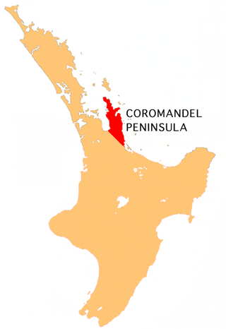
The Coromandel Peninsula on the North Island of New Zealand extends 85 kilometres (53 mi) north from the western end of the Bay of Plenty, forming a natural barrier protecting the Hauraki Gulf and the Firth of Thames in the west from the Pacific Ocean to the east. It is 40 kilometres (25 mi) wide at its broadest point. Almost its entire population lives on the narrow coastal strips fronting the Hauraki Gulf and the Bay of Plenty. In clear weather the peninsula is clearly visible from Auckland, the country's biggest city, which lies on the far shore of the Hauraki Gulf, 55 kilometres (34 mi) to the west. The peninsula is part of the Thames-Coromandel District and the Waikato Region.

Tiwai Point lies at the entrance to Bluff Harbour on the southern coast of the South Island of New Zealand. A spit which extends from the western end of the Awarua Plain, it lies between Awarua Bay to the north and Foveaux Strait to the south. It is known for the Tiwai Point Aluminium Smelter, one of the largest industrial facilities in New Zealand.

The Firth of Thames is a large bay located in the north of the North Island of New Zealand. It is the firth of the rivers Waihou and Piako, the former of which was formerly named the Thames River, and the town of Thames lies on its southeastern coast.

Little Barrier Island, or Hauturu in Māori, lies off the northeastern coast of New Zealand's North Island. Located 80 kilometres (50 mi) to the north of Auckland, the island is separated from the mainland to the west by Jellicoe Channel, and from the larger Great Barrier Island to the east by Cradock Channel. The two aptly named islands shelter the Hauraki Gulf from many of the storms of the Pacific Ocean.
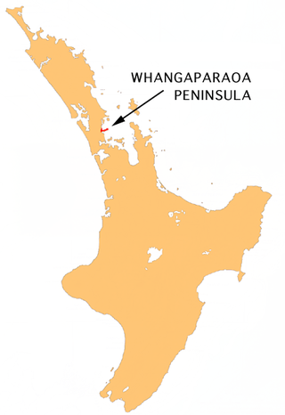
The Whangaparāoa Peninsula is a suburban area about 30–50 km north of Auckland, New Zealand. It had 33,390 residents in 2018. It stretches from Red Beach, where it connects to Kingsway, Orewa and Silverdale, and extends to Army Bay in the Hauraki Gulf. It is part of the Hibiscus Coast. The area is populated by residents who work on the peninsula, or commute from the area to other parts of the Hibiscus Coast, the North Shore, Rodney district, Auckland CBD and beyond for work. They travel by vehicle, or via the Gulf Harbour ferry at Gulf Harbour Marina, or the Hibiscus Coast Bus Station at Silverdale. There is one main road along its entire length, which is accessible from State Highway 1 via Hibiscus Coast Highway at Silverdale, or from Hibiscus Coast Highway at Orewa via Red Beach. It is popular as a tourist destination for catching a ferry to Tiritiri Matangi Island, and for visiting Shakespear Regional Park. It has one open (Whangaparāoa Golf Club) and one closed golf club (Gulf Harbour Country Club), beaches, sporting and recreation facilities, a library, shops, businesses and public and private primary and secondary schools. The median age of the population is in the 30s-40s.

SS Wairarapa was a New Zealand ship of the late 19th century plying the route between Auckland, New Zealand and Australia. It came to tragic fame when it hit a reef at the northern edge of Great Barrier Island, about 100 km out from Auckland, and sank. The death toll of around 130 people remains one of the largest such losses in the country's history. The ship was named for the Wairarapa region.

Kaikoura Island lies in an irregularly-shaped bay on the western side of Great Barrier Island in the Hauraki Gulf in New Zealand, 90 km (56 mi) north east of Auckland. Kaikoura Island is the seventh largest island in the Hauraki Gulf. It is 80 metres from Great Barrier Island at its closest point and forms the natural harbours of Port FitzRoy and Port Abercrombie. Its biota includes the endangered brown teal duck, the North Island Kākā and many native trees and shrubs.

Rotoroa Island is an island to the east of Waiheke Island in the Hauraki Gulf of New Zealand. It covers 82 hectares. The Salvation Army purchased it for £400 in 1908 from the Ruthe family to expand their alcohol and drug rehabilitation facility at nearby Pakatoa Island. Men were treated at Home Bay at Rotoroa, while women were treated at Pakatoa. This treatment facility was closed in 2005.

The Manukau Heads is the name given to the two promontories that form the entrance to the Manukau Harbour – one of the two harbours of Auckland in New Zealand. The southern head, at the northern tip of Āwhitu Peninsula, is simply termed "The South Head", whereas the northern head is named "Burnett Head". Both heads are hilly areas of land that rise steeply from the water to over 240m within less than 400m of the shoreline.
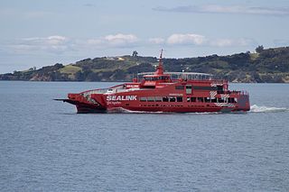
SeaLink New Zealand, formerly part of SeaLink Travel Group, operates a vehicle, passenger and freight ferry service on the Hauraki Gulf in Auckland.

The Mokohinau Islands (Pokohinau), sometimes spelt Mokohīnau Islands are a small group of islands that lie off the northeast coast of New Zealand's North Island. The islands are 100 km (62 mi) northeast of Auckland, 21 km (13 mi) northwest of Great Barrier Island and approximately 52 km (32 mi) east of Bream Head. The main islands of the group include Fanal Island (Motukino), Burgess Island (Pokohinu), Flax Island (Hokoromea), and Atihau Island. Smaller islands include Bird Rock. Most of them are managed by the Department of Conservation as nature reserves and wildlife sanctuaries. Landing is not allowed without a permit, with the exception of Burgess Island, much of which is managed as a scenic reserve by the Department of Conservation. The remainder of Burgess Island is Crown Land and is administered by the Ministry of Transport. The total land area of the Mokohinau Islands is 160 ha (400 acres).

Auckland is a large metropolitan city in the North Island of New Zealand. It has an urban population of about 1,478,800. It is located in the greater Auckland Region, the area governed by Auckland Council, which includes outlying rural areas and the islands of the Hauraki Gulf, and which has a total population of 1,739,300 as of June 2023. It is the most populous city of New Zealand and the fifth largest city in Oceania. While Europeans continue to make up the plurality of Auckland's population, the city became multicultural and cosmopolitan in the late-20th century, with Asians accounting for 31% of the city's population in 2018. Auckland has the fourth largest foreign-born population in the world, with 39% of its residents born overseas. With its large population of Pasifika New Zealanders, the city is also home to the biggest ethnic Polynesian population in the world. The Māori-language name for Auckland is Tāmaki Makaurau, meaning "Tāmaki desired by many", in reference to the desirability of its natural resources and geography. Tāmaki means "omen".

The Wairahi River is a river of New Zealand's Great Barrier Island. It is the only river on the island — the island's other watercourses all having names ending is "stream". The Wairahi flows generally west, roughly paralleling the island's long southwestern shore, from its origins north of Whangaparapara Harbour. A walking track from Whangaparapara to Port Fitzroy follows the river for part of its length.
Minginui is a town in Whakatāne District and Bay of Plenty Region on New Zealand's North Island.

Harataonga Bay is a coastal feature and area on the northeast coast of Great Barrier Island in New Zealand's Hauraki Gulf, approximately 51 nautical miles northeast of central Auckland. Most of the area is in the Harataonga Recreation Reserve, with some of the hinterland forming the Harataonga Scenic Reserve.
Ōkiwi is a small settlement and rural community at the head of the Whangapoua Estuary, in Whangapoua Bay, on Great Barrier Island in New Zealand's Hauraki Gulf.

Whangapoua Beach is on the east coast of Great Barrier Island in New Zealand's Hauraki Gulf. The beach runs roughly north–south and has views of Rakitu Island. The Whangapoua Creek drains large estuarine wetlands and enters the sea at the southern end of the beach.

Whangaparapara is a harbour and coastal community on Great Barrier Island in New Zealand's Hauraki Gulf.
