
Great Barrier Island lies in the outer Hauraki Gulf, New Zealand, 100 kilometres (62 mi) north-east of central Auckland. With an area of 285 square kilometres (110 sq mi) it is the sixth-largest island of New Zealand and fourth-largest in the main chain. Its highest point, Mount Hobson, is 627 metres (2,057 ft) above sea level. The local authority is the Auckland Council.

Waiheke Island is the second-largest island in the Hauraki Gulf of New Zealand. Its ferry terminal in Matiatia Bay at the western end is 21.5 km (13.4 mi) from the central-city terminal in Auckland.

Abel Tasman National Park is a New Zealand national park located between Golden Bay and Tasman Bay / Te Tai-o-Aorere at the north end of the South Island. It is named after Abel Tasman, who in 1642 became the first European explorer to sight New Zealand and who anchored nearby in Golden Bay.

Little Barrier Island, or Hauturu in Māori, lies off the northeastern coast of New Zealand's North Island. Located 80 kilometres (50 mi) to the north of Auckland, the island is separated from the mainland to the west by Jellicoe Channel, and from the larger Great Barrier Island to the east by Cradock Channel. The two aptly named islands shelter the Hauraki Gulf from many of the storms of the Pacific Ocean.
Motutapu Island is a 1,510 ha island in the Hauraki Gulf to the northeast of the city of Auckland, New Zealand. The island is part of the Hauraki Gulf Maritime Park. Its full name, rarely used, is Te Motutapu a Taikehu, "The sacred island of Taikehu", Taikehu having been a tohunga of the Tainui iwi. 'Motutapu', meaning "sacred" or "sanctuary" island, is a term used for various islands in a number of Polynesian cultures. The island can be accessed via regular ferry services departing from Auckland City.

Protected areas of New Zealand are areas that are in some way protected to preserve their environmental, scientific, scenic, historical, cultural or recreational value. There are about 10,000 protected areas covering about a third of the country. The method and aims of protection vary according to the importance of the resource and whether it is publicly or privately owned.

Te Paepae o Aotea, also known the Volkner Rocks, are a group of andesitic rock stacks and pinnacles located 5 kilometres (3.1 mi) northwest of Whakaari/White Island in New Zealand's Bay of Plenty. They reach 113 metres above sea level from 400 metres below the sea floor, while the saddle separating them from Whakaari/White Island is over 200 metres deep.

Cape Rodney-Okakari Point Marine Reserve is a 5.5 km2 (2.1 sq mi) protected area in the North Island of New Zealand.

Harataonga Bay is a coastal feature and area on the northeast coast of Great Barrier Island in New Zealand's Hauraki Gulf, approximately 51 nautical miles northeast of central Auckland. Most of the area is in the Harataonga Recreation Reserve, with some of the hinterland forming the Harataonga Scenic Reserve.

Sir Robert George Mappin Fenwick was a New Zealand environmentalist, businessman and professional director.

Ulva Island-Te Wharawhara Marine Reserve is a marine reserve covering an area of 1,075 hectares south-west and north-east of Ulva Island, in the Paterson Inlet of New Zealand's Stewart Island. It was established in 2004 and is administered by the Department of Conservation.

Waiau Glacier Coast Marine Reserve is a marine reserve of the West Coast Region of New Zealand's South Island. It covers an area of 4,641 hectares or 46 km2, from 11 km south from Kohuamarua Bluff near Ōkārito, to Omoeroa Bluff, and about 4 km out to sea.
Whakanewha Regional Park is a regional park situated on Waiheke Island in New Zealand's Hauraki Gulf. It is owned and operated by Auckland Council.
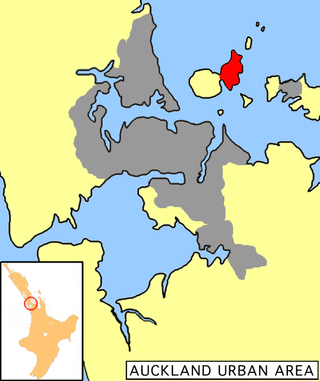
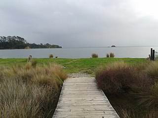
Te Matuku Marine Reserve is a marine reserve administered by the New Zealand Department of Conservation. It includes Te Matuku Bay, one of the largest and least disturbed estuaries on Waiheke Island, as well as a surrounding area of sea. It covers an area of 690 ha and was established in 2003.

Tauparikākā Marine Reserve is a marine reserve located offshore about 20 kilometres (12 mi) north of Haast on the West Coast of New Zealand's South Island. It covers the area immediately offshore from Ship Creek, which is also known as Tauparikākā in Māori.

Tāwharanui Marine Reserve is a marine reserve covering an area of 394 hectares in the Hauraki Gulf, offshore from the Tāwharanui Peninsula in the Auckland Region of New Zealand's North Island. It was established in 2011 and is administered by the Department of Conservation.
Te Angiangi Marine Reserve is a marine reserve covering a marine area of 446 hectares in the Hawke's Bay Region of New Zealand's North Island. It was established in 1997 and is administered by the Department of Conservation.

Westhaven Marine Reserve is a marine reserve covering an area of 536 hectares in the Whanganui Inlet at the top of New Zealand's South Island. It was established in 1994 and is administered by the Department of Conservation.

Taumoana Marine Reserve is a marine reserve covering an area of 464 hectares in Fiordland on New Zealand's South Island. It was established in 2005 and is administered by the Department of Conservation. It is located next to the Five Fingers Peninsula, at the entrance to Tamatea / Dusky Sound.
Te Hapua Marine Reserve is a marine reserve covering an area of 449 hectares of Te Hāpua / Sutherland Sound, in Fiordland on New Zealand's South Island. It was established in 2005 and is administered by the Department of Conservation.
