Related Research Articles

Great Barrier Island lies in the outer Hauraki Gulf, New Zealand, 100 kilometres (62 mi) north-east of central Auckland. With an area of 285 square kilometres (110 sq mi) it is the sixth-largest island of New Zealand and fourth-largest in the main chain. Its highest point, Mount Hobson, is 627 metres (2,057 ft) above sea level. The local authority is the Auckland Council.
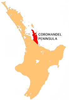
The Coromandel Peninsula on the North Island of New Zealand extends 85 kilometres (53 mi) north from the western end of the Bay of Plenty, forming a natural barrier protecting the Hauraki Gulf and the Firth of Thames in the west from the Pacific Ocean to the east. It is 40 kilometres (25 mi) wide at its broadest point. Almost its entire population lives on the narrow coastal strips fronting the Hauraki Gulf and the Bay of Plenty. In clear weather the peninsula is clearly visible from Auckland, the country's biggest city, which lies on the far shore of the Hauraki Gulf, 55 kilometres (34 mi) to the west. The peninsula is part of the Thames-Coromandel District of the Waikato region.

Cape Colville is the northernmost point of the Coromandel Peninsula in New Zealand's North Island. It lies 85 kilometres north of Thames, and 70 kilometres northeast of the city of Auckland, on the other side of the Hauraki Gulf. The small settlements of Port Jackson and Fletcher Bay lie immediately to the west and east respectively of the cape.
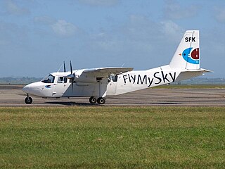
Fly My Sky was a small airline based in Auckland, New Zealand. It operated between Auckland, Matamata and Great Barrier Island. The airline went into liquidation at the end of June 2021. The airline evolved out of the now also defunct Mountain Air.

Barrier Air is a New Zealand airline that was established in 1983 by Jim Bergman as Great Barrier Airlines. The head office is located at the Domestic Terminal at Auckland Airport in Mangere, with additional offices in the terminal buildings at Great Barrier Aerodrome, Kaitaia Airport and North Shore Aerodrome.

Windy Canyon is a canyon and associated walking track on Great Barrier Island, New Zealand. Located in the centre east of the island, the canyon is a wind funnel shaped from andesitic rock. The canyon is located on one of the highest stretches of the island, less than 200 m below the 621 m summit of Mount Hobson. From the canyon it is possible to view the Okiwi and Awana lowlands.
Port Fitzroy is a harbour and coastal community on Great Barrier Island in New Zealand's Hauraki Gulf.
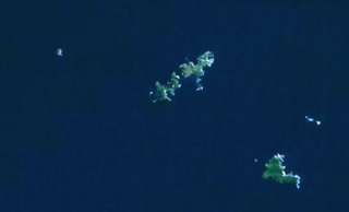
The Mokohinau Islands (Pokohinau) are a small group of islands that lie off the northeast coast of New Zealand's North Island. The islands are 100 km (62 mi) northeast of Auckland, 21 km (13 mi) northwest of Great Barrier Island and approximately 52 km (32 mi) east of Bream Head. The main islands of the group include Fanal Island (Motukino), Burgess Island (Pokohinu), Flax Island (Hokoromea), and Trig Island (Atihau). Most of them are managed by the Department of Conservation as nature reserves and wildlife sanctuaries. Landing is not allowed without a permit, with the exception of Burgess Island, much of which is managed as a scenic reserve by the Department of Conservation. The remainder of Burgess Island is Crown Land and is administered by the Ministry of Transport. The total land area of the Mokohinau Islands is 160 ha.

Harataonga Bay is a coastal feature and area on the northeast coast of Great Barrier Island in New Zealand's Hauraki Gulf, approximately 51 nautical miles northeast of central Auckland. Most of the area is in the Harataonga Recreation Reserve, with some of the hinterland forming the Harataonga Scenic Reserve.

Okiwi Airfield, also called Okiwi Station Airfield, is a small airfield located near the village of Okiwi on Great Barrier Island. It has a single bitumen runway, and a small terminal in the form of a wooden hut. The airfield is owned by Auckland Council and is used for general aviation.
Rakitu Island is an uninhabited 253 ha island off the northeast coast of Great Barrier Island in the Auckland Region of New Zealand. The island is also referred to as "Arid Island" and lies about 4 km (2.5 mi) off Whangapoua Beach, sheltering the bay of Whangapoua Creek.

Ōkiwi Bay is a small town in the Marlborough Sounds, New Zealand, within Croisilles Harbour. It has about 200 houses and about 80 permanent residents. The area was noted for its oysters.

Aotea Conservation Park is a 12,300 hectare protected area on Great Barrier Island in New Zealand's Hauraki Gulf. It was established in 2015, and comprises 43 percent of the island.
Kaitoke Beach is a long sandy beach and settlement on the east coast of Great Barrier Island in the Hauraki Gulf of the Auckland Region of New Zealand. At the northern end is the Kaitoke Creek, which drains the Kaitoke Swamp, and a headland, beyond which is Palmers Beach. At the southern end is the Sugar Loaf headland and beyond that Medlands Beach. Kaitoke Beach has golden sand and dunes.
Medlands Beach is in Oruawharo Bay on the east coast of Great Barrier Island in the Auckland Region of New Zealand. Auckland Council describes it as the most accessible beach on the island. It is one of the island's main tourist areas but is little developed. The small settlement of Medlands consists of permanent houses and holiday baches, some behind the dunes, sheltered from winds from the sea, and others elevated for a view.
Claris is a settlement on the east coast of Great Barrier Island in the Auckland Region of New Zealand. Though less populous than the main seaport area of Tryphena on the west coast, Claris functions as the administrative centre for the island, and a large proportion of its commercial and community services are based there.
Awana Bay is a beach on the east coast of Great Barrier Island in the Hauraki Gulf of New Zealand's Auckland Region.
Tryphena is a beach settlement on the southern coast of Great Barrier Island in the Hauraki Gulf of New Zealand's Auckland Region.
Whangapoua Beach is on the east coast of Great Barrier Island in New Zealand's Hauraki Gulf. The beach runs roughly north–south and has views of Rakitu Island. The Whangapoua Creek drains large estuarine wetlands and enters the sea at the southern end of the beach.
Whangaparapara is a harbour and coastal community on Great Barrier Island in New Zealand's Hauraki Gulf.
References
- 1 2 "Whangapoua Beach". greatbarrierisland.nz. Destination Great Barrier Island.
- ↑ "Okiwi Park". aucklandcouncil.govt.nz. Auckland Council.
- ↑ "Great Barrier Island services". A Visitor Information Guide to Great Barrier Island. Retrieved 27 March 2021.
- ↑ "New DOC base opened on Great Barrier". Beehive.govt.nz. New Zealand Government. 28 October 2016. Retrieved 27 March 2021.
- ↑ Palmisano, Kae Lani (12 August 2019). "What it's like to stay on the remote Great Barrier Island in New Zealand". USA Today.
- ↑ Smith, Catherine (18 March 2012). "Living it up on Great Barrier Island". New Zealand Media and Entertainment. New Zealand Herald.
- ↑ "Okiwi Passion". okiwipassion.co.nz. Okiwi Passion.
- ↑ Liptrot, Meg (5 January 2014). "Give back on a bach break". New Zealand Media and Entertainment. Herald on Sunday.
- ↑ "Okiwi Airfield" (PDF). aip.net.nz.
- ↑ Brodie, James W. "Mariano Vella". Dictionary of New Zealand Biography . Ministry for Culture and Heritage . Retrieved 26 June 2015.
- ↑ "Local board proposes new cemetery for Great Barrier". Auckland Council. Our Auckland. 22 February 2019.
Coordinates: 36°08′36″S175°22′32″E / 36.1434504°S 175.37547°E